Download
1 / 25
260 likes | 426 Vues
LAND REGISTRATION USING AERIAL PHOTO GRAPH IN NAMIBIA COSTS AND LESSONS. Donatha Kapitango Ministry of Lands and Resettlement Marcel Meijs German Development Agency. OUTLINE OF PRESENTATION. Introduction 2. Communal Land in Namibia 3. Communal Land Registration 4. Lessons Learnt

E N D
LANDREGISTRATION USING AERIAL PHOTOGRAPH IN NAMIBIACOSTS AND LESSONS Donatha Kapitango Ministry of Lands and Resettlement Marcel Meijs German Development Agency
OUTLINE OF PRESENTATION • Introduction 2. Communal Land in Namibia 3. Communal Land Registration 4. Lessons Learnt • Improving the site survey • Improving the registration of land rights • Roadmap • Challenges Customary Land Right Registration: Aerial photos
NAMIBIA • Size: 825 thousand km2 (1.5x France, 1/11 of USA) • Population: 2 Million • HIV infected: ca 20% • Climate: Savanna and Dessert • Independence: 1990 • GDP: $10.72 billion (2007 est.) • Main Exports: diamonds, uranium, (copper, gold, zinc, lead), cattle, fish, tourism • About half of the population depends on subsistence agriculture for its livelihood • One of the world’s most unequal income distributions Customary Land Right Registration: Aerial photos
POPULATION DISTRIBUTION • High density in the north, ca 50% of population • Due to favorable agricultural climate • Ca. 76% of the communal land rights will be allocated in the Northern part Customary Land Right Registration: Aerial photos
ADMINISTRATIVE LAND UNITS • In Namibia, land is divided into three administrative units: • commercial land (44%) • communal land (36%) • state land (20%) Customary Land Right Registration: Aerial photos
THE LAND ISSUE IN NAMIBIA • Access to land is believed to be one of the most pressing social, political and economical issue • Until independence, virtually all commercial land was owned by white farmers. 44% of land owned by 6% of population • There is a growing pressure on communal areas due to population growth and fencing of large areas. • Laws were put in place to tackle the above issues, but... Customary Land Right Registration: Aerial photos
COMMUNAL LAND REFORM ACT • Communal Land Reform Act (CLRA) was formulated to ensure a proper management of communal land • The Act transfers the responsibility to administer and allocate land rights in communal areas to Communal Land Boards and Traditional Authorities • The CLRA required that any person, should apply for recognition and registration of his/her customary land right before 1 March 2006 Customary Land Right Registration: Aerial photos
ROLE OF MLR IN COMMUNAL LAND REGISTRATION • MLR is the prime administrator of Communal Land • Assists the CLBs by providing: • Secretaries of the CLBs • Secure keeping of the (land registration) records • Surveying of communal land parcels • Diagrams and certificates for land rights • Financial and logistical support Customary Land Right Registration: Aerial photos
STEPS INVOLVED IN REGISTRATION • Applicant fills application form • Applicant requests a letter of consent from the local headman • Applicant supplies application to the TA • TA approves or disapproves and sends it to the CLB • CLB/MLR verifies the application, including a (GPS) site survey • CLB ratifies or rejects application, registersand communicates results back to the TA • TA, communicates to the applicant who pays on receipt of his certificate Customary Land Right Registration: Aerial photos
IMPROVING THE SITE SURVEY Lessons learnt after 5 years of site survey • 1389 land parcels registered • Average of 5 parcels could be mapped by one team a day • Lack of communication Therefore • A faster way to register parcels needed to be found • A new method should also ensure that fewer mistakes will be made • An intensive communication campaign needs to be done • Part of the work needs to be outsourced Customary Land Right Registration: Aerial photos
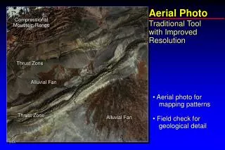
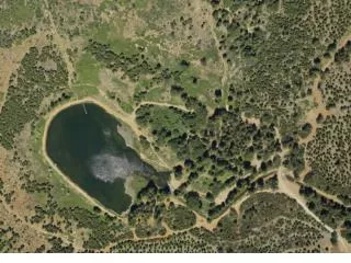
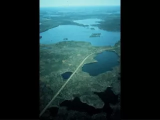
AERIAL PHOTOS FOR SURVEYING • Availability of 2007 Full color digital Aerial Orthophotos with a 1m resolution for the North • Easier and faster if features are visible • What you see is what you get (wysiwyg) • Community participation • Better suitable for systematic survey • Can be shown on survey diagrams • Size can be checked in the field • Multi-purpose Customary Land Right Registration: Aerial photos
What you see is what you get (wysiwyg) Customary Land Right Registration: Aerial photos
RESULTS AERIAL PHOTOS • 5x faster then GPS • Less prone for errors then GPS • Communities are better involved Customary Land Right Registration: Aerial photos
COSTS • The cost for a field team is estimated at 150 € • Quickbird images not covered cost €2.1 million Customary Land Right Registration: Aerial photos
IMPROVING THE REGISTRATION OF LAND RIGHTS Lessons learnt • No uniform register used • Inaccessibility of information • Incomplete registration • All outputs were made manual Therefore a new land administration system needed to enable • Easy information retrieval • Incorporate a unique parcel identifier • Secure storage Customary Land Right Registration: Aerial photos
METHODS USED TO IMPROVE THE LAND ADMINISTRATION • A new system named Namibian Communal Land Administration System (NCLAS) was developed • Similar to the Commercial Deeds and Cadastre • The NCLAS consists of two parts • Communal Deeds, MS Access • Communal Cadastre , ArcGIS Geodatabase • New Unique Parcel Identifier (UPI) • Automatedcreation of output • Certificates and diagrams • Register and index Customary Land Right Registration: Aerial photos
Namibian Communal Land Administration System NCLAS Application form Communal Deeds Approval or Rejection MLR/CLB verification UPI Aerial photos Communal Cadastre GPS Coordinates • Topography as : • Oshanas • Roads • Rivers • Town area • Commercial area • Land Use Plans • Development Plans • Legal borders (Region, constituency , etc. • Etc.
NCLAS OUTPUTS Customary Land Right Registration: Aerial photos
NCLAS OUTPUTS Customary Land Right Registration: Aerial photos
NCLAS OUTPUTS Customary Land Right Registration: Aerial photos
CONCLUSIONS ON NCLAS • Faster then the old process • Quality of output is better • Uniform • Data is now entered in a proper database • Data is accessible and secured Customary Land Right Registration: Aerial photos
ROADMAP • 2009-2013 • Communication campaign • Project management team • Register all (ca 300.000) existing land rights • Orthophotos and Quickbird • Outsourcing • NCLAS Central database developed • Maintenance structure Customary Land Right Registration: Aerial photos
CHALLENGES • The process of creating Awareness about the new law • To register all applications for existing land rights • Maintenance of the databases and IT infrastructure • Limited human and financial resources • Getting the right people at the right places • Transferring more responsibilities to lower authorities • Amending the law to accommodate regional differences Customary Land Right Registration: Aerial photos
Thank you for your attention Time for questions