Download
1 / 16
160 likes | 272 Vues
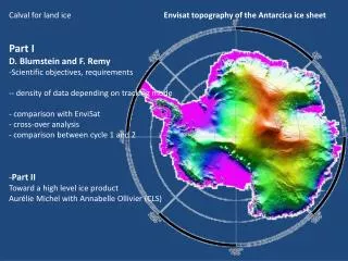
Calval for land ice Part I D. Blumstein and F. Remy Scientific objectives, requirements - density of data depending on tracking mode comparison with EnviSat cross-over analysis comparison between cycle 1 and 2 Part II Toward a high level ice product

E N D
Calval for land ice • Part I • D. Blumstein and F. Remy • Scientific objectives, requirements • - density of data depending on tracking mode • comparisonwith EnviSat • cross-over analysis • comparisonbetween cycle 1 and 2 • Part II • Toward a highleveliceproduct • Aurélie Michel with Annabelle Ollivier (CLS) Envisattopography of the Antarcicaicesheet
Scientific objective : icesheet mass balance. Follow on mission after ERS1/2 and EnviSat Heigth trend and accelerationfrom the 8yr of Envisat Les zones « côtières » doivent être particulièrement suivies
Main errors: • Across-trackslope • penetrationwithin the snowpack in ku-band Remy et al, 2013 • Need of a good repeatorbit to reach a final precision on the restitution of the trend: • Around few tens of repeat cycles, 50-60. • Need to reduce the penetrationerror Altika *** à cause de l’orbite et de la fréquence
Statistic for the lost point (with respect to EnviSat) Between15% and 20 % of data previouslyobservedby EnviSat are not observed by Altika Less by Ice-1 but also a lot of lost point
Points perdus par mode de suivi Le mode MNT… bof cf la plate-forme de Ross
Exemple de f.oretrackée par Ice-1 et pas par Ice-2 Explique un peu, mais pas tout
The orbitpreventsfrom a direct comparisonwith EnviSat In average: 2 km thenaround 2 m on heigth A problem for calval and for scientific objectives Comparaison des cartes moyennées des paramètres f.o Ou point de croisement
Comparison of waveformshapeparameter EnviSat Ku AltiKa Ka difference Backscatter (dB) Slope of the Trailingedge (s-1) Leadingedge (m)
Même effet aux xov qu’en Ku: effet complexe entre la direction de polarisation de l’antenne et celle de l’anisotropie de la surface
Heuh…. Enfin pas si sure… effet sur le flanc énorme Vérifier avec tous les tests possibles et imaginables….
Map of the heigth (in m) and in backscatter (dB) differencebetween cycle 2 and 1 Un peu fort… mais bon, on peut l’expliquer, joli signal géophysique La différence de hauteur semble liée à celle de la rétrodiffusion…. Y’a-t-il vraiment pas de volume dans Ka ?
Quant à l’évolution du flanc….. Vérifié « en aveugle » par Denis Que s’est-il passé à la trace 200 ou à la 1 du cycle 2….. ?
Conclusion • Difficile de faire la calval • (à cause de l’orbite, des effets de polar aux xov et de la variabilité temporelle) • Résultat • Beaucoup de perte de données à la côte… • - problème avec Ice-2 • gros problème incompréhensible avec le flanc • faudrait pas que cela cache quelque chose • qui affecte aussi le reste… comme la hauteur… • Au fait, il a-t-il vraiment pas de volume en ka…. • Sinon, superbes résultats dans les régions intérieures