Download
1 / 1
10 likes | 208 Vues
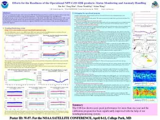
Efforts for the Readiness of the Operational NPP-CrIS SDR products: Status Monitoring and Anomaly Handling. Xin Jin 1 , Yong Han 2 , Denis Tremblay 3 , Likun Wang 4 1 I. M. System Groups, Inc., 2 NOAA/NESDIS/STAR, 3 Science Data Processing, Inc., 4 UMCP Contact: xjin@noaa.gov.

E N D
Efforts for the Readiness of the Operational NPP-CrIS SDR products: Status Monitoring and Anomaly Handling Xin Jin1, Yong Han2 , Denis Tremblay3, Likun Wang4 1 I. M. System Groups, Inc., 2 NOAA/NESDIS/STAR, 3Science Data Processing, Inc.,4UMCP Contact: xjin@noaa.gov Abstract The Cross-track Infrared Sounder (CrIS) onboard the NPP (NPOSS Preparatory Project) satellite has been on orbit for more than one year. To facilitate the readiness of the operational products, a web-based instrumental status and SDR product trending/monitoring system is set up at NOAA for operational use. Meanwhile, the offline CrIS calibration system (ADL) is used for diagnosing the anomalies found in the operational products through the monitoring/trending system. In the past year, some critical anomalies are diagnosed and solutions are suggested. With these efforts, the readiness of the operational SDR products significantly improved. 2.Debugging the operational program A number of program bugs and operational mistakes have been detected based on the trending/monitoring system. 2.1 Typo in geo-location module A typo was found in the geo-location module. This typo caused an error of around 4 km in geo-location calculation. This bug is fixed already in MX6.2. 2.2 Bit-trim mask (BTM) initialization with invalid values The incorrect initial BTM table was loaded into the sliding window when the engineering packet was not found in the first of the night granules, resulting in complete wrong spectra. This was fixed shortly after the beginning of intensive cal/val. 2.3 Time stamp calculation without month change The calculation of time stamp doesn’t consider the month change; therefore arbitrary memory values were assigned to the all members in the spectral object corresponding to this time stamp. After calibration, very strange spectral radiances are derived. The fix has been ingested into MX7.0. 2.4 Loss of initial neon calibration counts in CMO file The neon calibration count table is updated every four minutes by overwriting the previous values with new values from engineering packet; however the CMO matrix is calculated based on the laser wavelength derived from the initial values when a program is started and should not be recalculated as long as the laser wavelength drifting is less than 2 ppm. Moreover, if the CMO matrix is not updated, the re-sampling laser wavelength, which is used to interpolate the spectral radiance into the user grid, should not change as well. When the program is started with an existing CMO file, the laser wavelength calculated from the new table is different with the one used in the calculation of CMO matrix but it is still treated as the initial value. Therefore the re-sampling laser wavelength is updated based on the new neon laser wavelength. The solution for this bug is to keep the initial laser wavelength information in the CMO file. This suggestion has been adopted and will be implemented in MX7.0. 2.5 Re-tasking with existing CMO file excluding correct BTM table Occasionally a RDR granule is incomplete and the SDR program should be re-tasked when the repaired RDR granule is available. In operational mode, an existing CMO file is used to save time. This operational method will cause the same result as described in 2.2 when the engineering packet is not included in the first granule. This bug could result in the distortion of spectra in up to 8 minute. Since the incomplete RDR granule is usually caused by the disconnection in down-linking data from satellite to the Svalbard Island ground station, a lot of SDR products in the Arctic areas have been affected by this bug. The suggestion of archiving the latest BTM table in CMO file has been adopted and will be available in MX7.0. 2.6 Missing scan in SDR products (time stamp jump) We have observed a lot of missing scan cases in SDR granule products by seeing the time stamp increment between two continuous scans is 16 seconds instead of 8 seconds. This is caused by the missing of the Earth Scene packets in the first of the 30 field of regards (FORs). In current code, the time stamp of the Earth Scene packet in the first FOR is used as the evidence of the existence of this scan. If it is missing, the whole scan is treated as missing and the next scan is lifted up into the sliding window. STAR and NGAS are cooperated to provide a fix and it will be implemented in MX7.1. 2.7 Same scan duplication in different granules This is caused by the missing scan bug described in 2.6. The fix for the missing scan issue will also fix this bug. 2.8 Distorted Earth Scene (ES) spectra Sometimes, the missing of ES packets in the FORs makes the program to pick up an arbitrary memory value to fill the gap; and this arbitrary value is treated as the raw spectra in the calibration, resulting in very distorted ES spectra. The fix for the missing scan will also fix this one. 2.9 Quality flag logic error The initial values of all quality flags in SDR products are assigned with 0 (good). All the logic trees in the calibration program are based on this design. For example, when a granule is treated as the ‘short granule’, i.e., the fourth scan is not available, the calibration for this scan is skipped but the quality flag for this scan is still filled with 0 (good). The fix for this bug is still in progress. 2.10 RDR data quality survey (‘A2’ issue) The survey of the spatial and temporal distribution of the incomplete science RDR granule (‘A1’) and its repaired version (‘A2’) is conducted at NOAA/STAR. It is found that the root cause of the incomplete RDR granule is due to the sudden loss of contact between satellite and the ground station during the data transportation. Usually this incomplete granule can be fixed during the next contact. It is also found that since last September, in a typical day, the percentage of A2 granules is about 1% (~27 files) of total granules. Moreover, most of the loss happens to the spacecraft diary packets and only about 20% happens to the science packets. 2.11 Degraded SDR quality flag by missing telemetry packet We observed a frequent occurrence of a whole scan marked as degraded quality around the Arctic area. It is a calibration code bug. When the telemetry packet is missing in a sliding window and no more scans with correct telemetry packets are followed in a sliding window, the calculation of the number of valid PRT temperature counts in this sliding window is aborted and the initial value which is 0 is not updated with the actual value. This value is smaller than the limit (15), and in this case, the pixels in this scan are marked as ‘degraded’. 2.12 Other anomaly events caused by improper manual operation Some other anomaly events were caught by our system and were reported to community in time, including the CMO anomaly in late last May and early last June, the spacecraft instability in early last June, a couple of single-bit error anomalies, several lunar calibration events for VIIRS, a manual operation mistake on last December 26, and etc. • Trending/Monitoring system • https://www.star.nesdis.noaa.gov/smcd/spb/xjin/index.php All of CrIS SDR products, most of science RDR/telemetry RDR, and a number of housekeeping RDR parameters are monitored. For each parameter, both the 8-second raw resolution record and the hourly averaged statistics are archived. Svalbard The Lunar Intrusion (LI) occurred on both scanning directions shows an integrated history of the position evolution between spacecraft and the moon. Both the seasonal and monthly patterns are very clear. The sudden drop of daily percentage of degraded SDR pixels in late June 2012 indicates the algorithm improvement by adjusting the thermal drifting limits. After the adjustment, the degraded pixel percentage drops to around 0.1%. The history of daily averaged long-wave deep space (DS) spectral stability catches the increase of spectral noise of the DS imaginary part radiance since last October. The root cause is still under investigation. Summary The CrIS has shown users great performance for more than one year and the calibration program has been significantly improved with the help of our trending/monitoring system. The above plots show the impact of the annual cycle of the internal environment on the instrument’s performance. The instrument was closer to the sun between last October and this March, causing the increase of internal temperature, and resulted in the decrease of neon laser wavelength, the decrease of instrumental gain, and the increase of offset. However, the NEDN is very stable and has no seasonal pattern. Poster ID: W-57. For the NOAA SATELLITE CONFERENCE, April 8-12, College Park, MD