The Interactive Grid Analysis and Display System (IGrADS) for the U.S. Armed Forces
420 likes | 1.19k Vues
The Interactive Grid Analysis and Display System (IGrADS) for the U.S. Armed Forces. Major Lee A. Byerle Chief, Warfighter Support Development Team HQ Air Force Weather Agency Lee.Byerle@afwa.af.mil 5 Oct 05. IGrADS. IGrADS developed at Air Force Weather Agency (AFWA)

The Interactive Grid Analysis and Display System (IGrADS) for the U.S. Armed Forces
E N D
Presentation Transcript
The Interactive Grid Analysis and Display System (IGrADS) for the U.S. Armed Forces Major Lee A. Byerle Chief, Warfighter Support Development Team HQ Air Force Weather Agency Lee.Byerle@afwa.af.mil 5 Oct 05
IGrADS • IGrADS developed at Air Force Weather Agency (AFWA) • Available over JAAWIN (AFWA’s website) • https://weather.afwa.af.mil/igrads.html • Background • MM5 declared operational at AFWA Oct 97 • Up to 30 theaters covering 98% of world’s landmasses • Large numbers (> 250,000) of visualizations were pre-staged daily from AFWA’s MM5 output • Problem: excessive amount of processing needed to create visualized products
Interactive Solution • Challenge: we needed to create an interactive tool • Allow forecasters to create the charts they needed • This tool would allow large amounts of processing power to be freed up for production and developmental efforts • Initial interactive capability - IMaST • Unveiled on JAAWIN in May 2001 • Limited to meteograms and forecast skew-Ts • Immensely popular with forecasters and customers • Expanded capability - IGrADS • Fielded in Feb 2002 • Capability expansion continues through the present • Available models and product types expanded significantly beyond IMaST
Model Choices { https://weather.afwa.af.mil/igrads.html
Available MeteorologicalModels • AFWA MM5 (will transition to WRF) • AFWA Diagnostic Cloud Forecast (DCF) Algorithm • AFWA Stochastic Cloud Forecast Model (SCFM) • NCEP GFS • NCEP Eta (becoming NAM) • US Navy NOGAPS • US Navy COAMPS • UKMO (Middle East Theater)
{ Product Choices https://weather.afwa.af.mil/igrads.html
Products offered by IGrADS • Meteograms (MM5, Advect Cloud, GFS, Eta, NOGAPS, COAMPS, and UKMO) • MM5 Army low-level meteograms • MM5 severe weather meteogram • GFS meteograms (0 to 180 hour and 192-384 hour) • GFS and NOGAPS stratospheric meteograms • User defined meteograms • Forecast skew-Ts
Products offered by IGrADS(continued) • Vertical cross-sections • Multiple leg cross-sections • Forecast maps (color filled, contoured, both) • Alphanumeric output products • Four-panel forecast maps (five different types) • AFWA Worldwide Merged Cloud Analysis
IGrADS AlphanumericProducts • MM5-based • Forecast vertical profile • “FOUS” bulletin (similar to Eta and NGM output from NCEP) • RAOB bulletin • Precision airdrop wind profile • Chemical downwind message • Basic wind message • Field artillery forecast • GFS-based • “FOUS” bulletin (0 to 180 hours at 3 hour intervals) • RAOB bulletin • Precision airdrop wind profile • Chemical downwind message • Basic wind message • COAMPS-based • Basic wind message
IGrADS Map Display Options • World Map centered on Prime Meridian • World Map centered on International Dateline • All MM5 theater maps • United Kingdom Meteorological Office (UKMO) Middle East domain • Continental United States (CONUS) NAM (Eta) domain • Coupled Ocean/Atmospheric Mesoscale Prediction System (COAMPS) Middle East domain
MM5 User Defined MeteogramNorthern Siberia Winds, temperatures, clouds, RH, and icing Sea Level Pressure and 1000-500 mb thickness 1000-850 mb and 850-700 mb thicknesses Surface winds (knots) Surface visibility (km) 3-hour precipitation, amount and type Surface temperature, DP, and wind chill
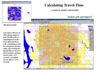
Vertical Cross SectionHurricane Frances (Valid 30 Aug 04/0000Z), directly through the eye Relative Humidity FL winds Vertical velocity Potential temperature Turbulence
{ Display Options Forecast Maps submenu
Forecast Map (IGrADS) SLP, 1000-500 mb Thickness Chart, Winds, Precip
Forecast Map Super Typhoon Chaba(valid 25 Aug 04/1200Z), south of Japan Surface winds (knots) (color-filled) Sea Level Pressure contours (mb) (black)
Forecast Map and User Defined MeteogramConvective wind gust potential, southeast Australia
Standard Forecast #1 Four-Panel MapHeavy snow, freezing rain over Ohio, 24 Dec 04 700 mb heights and RH (contours), and 700 mb vertical velocity (color filled) 500 mb heights (dm), 500 mb temperatures (C), and 500 mb relative vorticity (color filled) Sea level pressure (mb), 1000-500 mb thickness (dm), and 3-hour precipitation (color filled) 925 mb heights, winds (barbs), and RH (color filled)
Winter Weather Four-Panel Forecast MapHeavy snow, freezing rain over Ohio, 24 Dec 04 1000-850mb thickness, 925 mb winds, and 3-hr snowfall 1000-500 mb thickness, 700 mb winds, and 3-hr precipitation Surface temperature and precipitation type (color filled) Surface visibility, surface winds, and wind chill temperature
Severe Weather Four-Panel Forecast MapCentral South Africa,forecast valid 5 Oct 05/1800Z Total Totals SWEAT Index CAPE K-Index
Stochastic Cloud Forecast Model (SCFM)Meteogram and Forecast Map, Valid 21 - 23 Dec 04
IGrADS Case Study 20-22 April 2002 Snowstorm,Northern Plains and Upper Great Lakes
MM5 48-Hour Accumulated Snow Forecast, 20-22 April 2002
CONUS 15-km Vertical Cross Section Options
B A A B
D C C D
IGrADS Customer Feedback • Kadena AB, Okinawa: “ … we often use your site for planning missions up to 72 hours out. The forecasts aid greatly in our decision making during the planning and execution phases of our missions (air refueling, air delivery, low level flight, short field landings, and basic point A to point B logistics flights).” • Thule AB, Greenland: “I usually print out a vertical cross-section and include it with the pre-takeoff briefing package. Aircrews rave about the product.” • Captain deployed in Afghanistan: “IGrADS has been the decisive difference we need. I use it extensively … especially the Afghan 5 km window for the model skew-Ts.”
Summary • IGrADS is the DoD’s premier interactive weather forecast visualization tool • Available through AFWA’s JAAWIN website • Wide range of meteorological models • Broad array of products (visualizations and alphanumeric) • Product availability for the entire globe • Continued expansion of capabilities ongoing • Additional models, observational data • Space weather forecast and observed products • Accelerated product creation and delivery https://weather.afwa.af.mil/igrads.html