Download
1 / 18
180 likes | 492 Vues
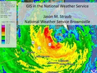
GIS in the Enterprise Presentation for National Weather Service Tech Days October 30, 2008 Dan O’Leary Enterprise Solutions, ESRI. Geographic Information System (GIS). A GIS is a system for the Management, Analysis, Visualization and Dissemination of Geographic Information….

E N D
GIS in the Enterprise Presentation for National Weather Service Tech Days October 30, 2008 Dan O’Leary Enterprise Solutions, ESRI
Geographic Information System (GIS) A GIS is a system for the Management, Analysis, Visualization andDisseminationof Geographic Information… … for effective, timely, and efficientcollaboration, problem solving, anddecision-making. Enterprise Lab 2
Land/Property Management GIS is Used to Build Information Systems … providing many capabilities … in many industries … Command & Control Business Analysis Incident Management • Federal Government • State & Local Government • Natural Resources • Utilities • Transportation & Logistics • Intelligence • Defense • Science & Technology • Public Safety • Homeland Security • Environmental • Water/Wastewater • Telecommunications • Weather / METOC • Agriculture • Energy • Mining • Insurance/Banking • Retail • Real Estate • Education Network Management Facility Management Image Management Cartographic Production Resource Management
GIS Has Evolved - Supporting the EnterpriseInfrastructure, Architecture, and Application Technology Traditional Contemporary Emerging Client / Server Web Services Services Oriented Architecture • Integrating Distributed Data and Applications • Connecting Communities and Enabling Collaboration • Supporting Real-time Operations • Powering the Specialist—and Reaching the Generalist . . . and delivering critical mission capabilities
Corporate Portal (User-customisable) GIS (ArcGIS Desktop) Specialist Apps (Business/GeoScience) www Internet (search, trade journals, hosted services) Browse (folders, categories) Search (spatial, text, natural language) Geoparsing & Geocoding Business Catalog (Central Asset Register) GIS Catalog (Metadata per layer) A B Federated DBs (joint-up business net) Library Records (incl. hardcopies) Documents (Livelink EDMS) C Shell OilGeocentric Enterprise Example User Application interfaces Find & Retrieve Corporate Memory Imagery (Satellite, Grids) Federated GIS DBs (joined-up GIS net)
ArcObjects SearsGeospatially Enabled Enterprise Example GIS Based Service Area Planning Forecasted Demand Available Fleet Sears Enhanced Home Delivery System (EHDS) Warehouse Optimization Routing forklifts Nationwide Geocoding and Route Optimization • Customer Request • Home Delivery OR • Home Product Repair • Customer Service • Delivery Vehicle departs to your home to Deliver Merchandise • Service Technician Departs to your home for Product Repair Mainframe CIS Computer Aided Routing System (CARS) Mobile Mapping Capacity Area Management System (CAMS) Geocoding and Route Optimization In-Vehicle Navigation Assign Technicians to work areas
Hillsborough County CollaborationGeospatially Enhanced Enterprise Example Public Access Portal County Ops Center Geodatabase Replication Web Service Live Weather Evacuation Zones Evacuation Zones Real-time Evac Info Web Services Web Services Electricity Outages Impact Probability Shelter Routing Shelter Status Color Imagery Job Search Infrared Imagery Available Jobs Production Geodatabase Publication Geodatabase
Enterprise Infrastructure Technology Developments in … • Faster Processing • Multi-core, Blades • Increased Bandwidth • Larger Storage • Web Services Standards • Mobile Technologies • Real Time Networks Servers Desktop Scalable Networked Hardware Web Services Laptop PDA Phone … accommodate GIS demands … • Unique imagery and mapping content, and a variety of data models/formats • Very large, distributed databases • Legacy systems built around computing and integration constraints . . . and enable integration in mainstream applications
Evolving Enterprise Architectures Services Oriented… 3-D Viewers Clients Rich Internet Client 2-D Viewers Consume / Use Integration Platform Map & Chart Open Web Tracking & RSS Catalog Geo- Process Image- Process Services Globe Serve Data Author / Publish Rapid development, legacy integration, interoperability, integration, sustainability…
+ + Mashups GIS Services & Web Content GIS Servers GIS is Evolving on the Web 2.0 PlatformIntuitive Integration with Multiple Information Systems • Consumer Base Maps & Content • Geo-Referenced Web Content Web Users GIS Users Sensor Networks GIS Geo-Referenced Web Content GIS Knowledge Web Maps & Globes (Google & Microsoft) . . . Creating a New Kind of Geospatial Framework . . . In an Open and Interoperable Environment
Advancing GIS TechnologyComprehensive, Robust Platform … • Rich Application Clients • Standard Development Environments • Out-of-the-Box GIS Services • Easy to Install & Manage • Scalable • High Performance • Interoperable • Affordable Desktop GIS Server GIS Online GIS Delivering • Advanced Cartography • Visualization—2D and 3D • Spatial Analysis and Modeling • Temporal Analysis and Modeling • Data Management • . . . Enabling Enterprise GIS
Engage and Serve Multiple Stakeholders Different, legitimate enterprise perspectives … • Users – Problem Solving • Implement Data Management (Creation, Collection, Editing), Analysis (Models, Workflow), and Visualization capabilities. • CIO/IT – Reliability and Efficiency • Optimize IT performance—stability, scalability, security ,economy; comply with standards; and deliver on-time/on-budget projects. • CEO/CFO - Business Value • GIS-enable mainstream applications on an integrated IT foundation, unifying organizations and delivering strong ROI. … requires sustained Governance comprising executive champion, IT, security, budget, contracts, and users.
Serving Mainstream Business NeedsQuality, Timeliness, Efficiency Visualization Information Integration Analysis/Workflow More than maps and imagery … a foundation for business planning and execution Common Operating Picture
Mission Requirements Identify Services Mission Governance Design SOA Framework Measure Infrastructure 3 month cycles Build Use IT Governance Deploy Evaluate Test Library of reusable services Service Registry Build Agile Geospatial Solutions--SOA Rapid Prototyping in Development “Spirals” Incremental Migration to Exploit Legacy Service Enabled Components Existing Capabilities Legacy Legacy Wrap Connect Enterprise Service Bus Legacy COTS-Based Replacement Replace Service Connectors Retire Deactivate Better managingrisk, cost, and IT resources
Enterprise GIS BenefitsQuality, Timeliness, Efficiency • Integrate disconnected GIS applications • Integrate GIS with other enterprise applications • Rationalize overlapping development efforts • Improve geospatial data management and applications • Optimize IT infrastructure efficiency and performance • Improve access to geographic information • Use geography to fuse enterprise knowledge • Deliver new geospatially-based products and services • Accelerate the analysis and decision cycle • Extend geospatial capabilities to generalists