Download
1 / 34
340 likes | 530 Vues
Preliminary Simulation of Typhoon Rananim with AREM. Rucong Yu, Rui Cheng, Youping Xu Chengzhi Ye, and Aihua Xu. LASG, IAP, CAS. Jun. 1, 2005. CONTENTS. Brief Overview of Typhoon Rananim. Observational Features. Experimental Design. Model Verification. Summary and Conclusions.

E N D
Preliminary Simulation of Typhoon Rananim with AREM Rucong Yu, Rui Cheng, Youping Xu Chengzhi Ye, and Aihua Xu LASG, IAP, CAS Jun. 1, 2005
CONTENTS Brief Overview of Typhoon Rananim Observational Features Experimental Design Model Verification Summary and Conclusions
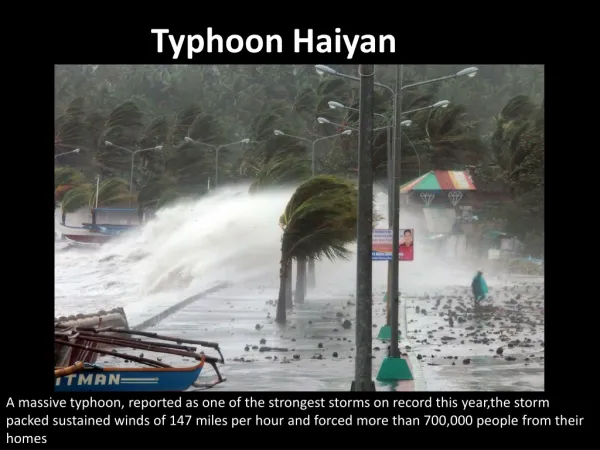
Landfall in Zhejiang occurred at 1200UTC on Aug. 12, 2004 • Although early detection of Typhoon Rananim cut losses to a minimum , It ravaged the Chinese eastern provinces. Confirmed by meteorological authorities to be the worst typhoon to hit China since 1956. “Rananim” won’t be used to name typhoon in future and as the specified name of Typhoon NO. 14 last year.
Affecting the lives of 18.18 million people, the strong winds and torrential rain caused more than 21.04 billion Yuan (U.S. $2.53 billion) in direct economic losses. • Demolishing 212,600 homes and damaged reservoirs and power communication facilities. • The death toll was at 183, while about 500,000 were evacuated from their home.
Two men try to prevent a tricycle from being blown away by a gale in Wenzhou, Zhejiang, on August 12, 2004. A Chinese family was drenched by the storm in the city of HangZhou, August, 12, 2004.
Evolution Stages • At 12 UTC, 08AUG2004, originating from tropical disturbance at the ocean surface in the east of Philippines • At 18 UTC, 10AUG2004, intensified to Typhoon Rananim • At 12 UTC, 12AUG2004, landfall over Zhejiang Province and moving westward • At 03 UTC, 13AUG2004, weakening to tropical storm • At 09 UTC, 13AUG2004, reducing still to depression
Basic Features At the landfall • Minimum SLP, 950 hPa • Maximum wind, 58.7 m/s • Strong small eye storm, its diameter approximates to 45km • Precipitation, 874.7mm/24h; 600mm/12h • Strong echo appearing at the levels between 3 and 6km, not very high • Large affected area
Data used: Typhoon Rananim’s Warning Report Intensive surface observations NCEP Analysis Data Conventional observations IR-Cloud images and TBB Data of Goes-9 Doppler Radar images
Track of Rananim (Provided by Zhejiang Meteorology Administration)
Precipitation by Rananim (Provided by Zhejiang Meteorology Administration) 0000 UTC, 12~ 0000 UTC, 13
Radial velocity from Doppler Radar at Wenzhou Vertical slice of Radar echo Averaged echo height from Doppler Radar at Ningbo
AREM Overview • Advanced Regional Eta-coordinate Model • Dynamic core, fully energy-conservative time-space difference • Vertical coordinate, η, Horizontally spaced in Arakawa E-grid • Moisture transportation, Two-step Shape Preserving Advection Scheme (TSPAS) • Initialization, De-grib NCEP analyses, or Cressman Iteration • Physical processes, simple but practical • Model mesh, nested • Used to forecast heavy rainfall operationally, to perform typhoon, environmental simulations etc. • Good performance in simulating and forecasting Chinese torrential rainfall
Domain Mesh A Mesh B Area coverage X: 85E150E Y: 5N60N Z: surface10 hPa X: 111E131E Y: 16N36N Z: surface10 hPa Dimensions (grid numbers) 13122132 12124132 Grid size (km) ~37km ~12km Time step (s) 225s 90s Integration hours 1200 UTC on 11th 0000 UTC on 14th 1200 UTC on 11th 0000 UTC on 14th Initial conditions NCEP Analysis (1°×1°), Without Bogus Physical processes Betts-Miller C.P., non-local PBL, Warm-cloud M.P. , Weekly SST Experimental Design and Initial Conditions
Model Verification Storm-scale fields Mesh B Synoptic fields Mesh A IV.
a) Synoptic fields (Mesh A) obv 18Z11Aug2004 00Z12Aug2004 06Z12Aug2004 fct Height (colored) and temperature (black) on 500 hPa
a) Synoptic fields (Mesh A) obv 18Z11Aug2004 00Z12Aug2004 06Z12Aug2004 fct Rel. Hum. (colored) and stream (black) on 700 hPa
a) Synoptic fields (Mesh A) obv 18Z11Aug2004 00Z12Aug2004 06Z12Aug2004 fct Total moisture flux divergence and stream on 700 hPa
b) Storm-scale fields (Mesh B) 0300 UTC 12AUG2004 0400 UTC 12AUG2004 0500 UTC 12AUG2004 Infrared Satellite images (lower) and a top view of the simulated hydrometeors (upper), as determined by the 0.1g/kg surfaces
b) Storm-scale fields (Mesh B) 0600 UTC 12AUG2004 0700 UTC 12AUG2004 0800 UTC 12AUG2004 Infra Satellite images (lower) and a top view of the simulated hydrometeors (upper), as determined by the 0.1g/kg surfaces
b) Storm-scale fields (Mesh B) Streamline on 700 hPa and Precipitation Rate (mm/h)
A 3-D view of constant surface of equivalent potential temperature =346K 1113 1117 1121 1201 1205 1209
b) Storm-scale fields (Mesh B) Hydrometeors (shaded, kg/kg) and vertical velocity (black, hPa/s), longitudinal and latitudinal slice near the core
Pseudo-equivalent potential temperature (K), vertical slice near the core
Observed and simulated rainfall (mm) from 1200 UTC 11AUG2004 to 1200 UTC 12AUG2004 B B obv. mesh A mesh B
observed simulated Evolution of daily rainfall (mm)
Track of Typhoon Rananim 12Z12 06Z12 00Z12 18Z11 Red: observed Blue: simulated(~12km) 12Z11
Evolution of SLP (hPa) ~20 hPa Red: observed Blue: simulated(12km) Evolution of traveling speed (km/h)
1 AREM simulates Typhoon well, Track, thermodynamic structures, landfall time and location, and evolution 2 Reasonable multiple structures of Typhoon obtained, Environmental background, eye, eye-wall, and spiral rain bands 3 Further studies mainly focus on, with some problems sensitivity experiments, incorporation of Bogus scheme into AREM
Thank you! Welcome comments and advice!


![[Preliminary Simulation Results on Power Saving]](https://cdn5.slideserve.com/9731281/preliminary-simulation-results-on-power-saving-dt.jpg)