Download
1 / 14
140 likes | 165 Vues
Join our practical field course in Geo4840 Tectonics and explore the unique geology of the Atløy-Sunnfjord-Bergen region. Learn about mapping, rock structures, and deformation/metamorphism during the evolution of the Scandinavian Caledonides.

E N D
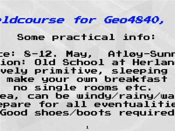
Intro fieldcourse for Geo4840, Tectonics Some practical info: Time and place: 8-12. May, Atløy-Sunnfjord-Bergen Accommodation: Old School at Herland on Atløy Relatively primitive, sleeping bags, make your own breakfast no single rooms etc. Exposed area, can be windy/rainy/warm/cold so prepare for all eventualities. Good shoes/boots required 1
Practical info: Detailed mapping on economics maps scale 1:5000. I will provide the detailed maps. For location and use in report you can use the roadmaps; or (print from: http://ngis2.statkart.no/norgesglasset/default.html ) You can also print/look at arial photographs of (variable quality) at: http://www.norgeibilder.no/ For the mapping we require normal writing and drawing equipment; GPS, hand-lense, compass w/clinometer, hard plate for maps, water/wind protection. In the Brurestakken are we normally refrain from use of hammers because of frequent use and destruction of outcrops, but you should bring hammers for other part or the trip. I will provide GPS’s; if you own one yourself or have access to one, let me know. 2
Remember: Reports from field course is 1/3 of the course evaluation. You deliver: Digital file + paper hard copy containing a) Excursion report, with locations and descriptions illustrations/ discussion of all stops made during the field trip. (individual reports) b) Report from the mapping containing 1) Introduction, methods, map basis etc. 2) Systematic description, illustrations and measurements of rocks (contacts, petrography and primary structures/sedimentology) 4) Systematic description and measurement of deformation/ metamorphism including folds, foliations and linear structures, faults, veins etc. 5) Presentation of map(s), cross-section(s) and structural data (stereograms, kinematic/dynamic interpretations) 6) Summary/conclusions/problems/suggestions etc. Please observe that you make a specific report for the Geo4840 part of the course, i.e. Sunnfjord area and the excursions connected to this. 3
Intro field-course for Geo4840, Tectonics I will take over the group on Monday 8/5 after you have been working with Arild Andresen on structural problems at Bremanger the week before. We will have ca 2.5 days of individual mapping in relatively small, but well exposed areas around the little mountain called Brurastakken (the bride’s-dress) near Herland on Atløy. The geology of Atløy is quite unique because it provides a structural/stratigraphic section from continental to oceanic rocks, and in addition evidence for several time-separted stages of deformation and metamorphism during evolution of the Scandinavian Caledonides. 4
Intro field-course for Geo4840, Tectonics We will focus EXCURSIONS: 1) The Proterozoic basement with Caledonian overprint (eclogite facies to decompression fabrics and mineralogy) 2) Large-scale extensional mylonites in the Nordfjord-Sogn Detachment zone 3) Caledonian infra-structure of the nappe complex (The stratigraphy and tectonostratigraphy) a) Basement-cover nappes and evidence for polyphase deformation and metamorphism b) Ophiolite and sedimentary cover c) Accreation of oceanic rocks to the continent and the response in stratigraphy of the to this process. THE MAPPING EXERCISE With focus on the last point above 5
Nordfjord-Sogn Detachment Zone Bremanger Atløy Bergen area 6
Bremanger Localities to be visited Atløy 7
SUMMARY OF GEOLOGICAL UNITS IN THE SUNNFJORD REGION Andersen et al. 1985-1995 U/Pb zircon syenitic gneiss: 1634±3 Ma
true scale N-S palaeo-reconstruction of stratigraphic units in the Sjøralden formation of the Herland Group, Atløy notice that the vertical scale i x10 the horizontal 11
SUNNFJORD MELANGE HERLAND GROUP HØYVIK GROUP 12