Download
1 / 72
750 likes | 1.24k Vues
Political Geography. "We live in a political world ..." Bob Dylan " In politics, stupidity is not a handicap ." Napoleon Bonaparte (attributed). Definitions: "States" & "States". " States " States are political units that have: Defined territories; A permanent population;

E N D
Political Geography "We live in a political world ..." Bob Dylan "In politics, stupidity is not a handicap." Napoleon Bonaparte (attributed)
Definitions: "States" & "States" • "States" • States are politicalunits that have: • Defined territories; • A permanent population; • Are fully independent and sovereign. • "States" • States are politicalunits that are: • Part of a federal government; • Have limited independence (or sovereignty). • Sovereignty: control of internal affairs, without interference by other states. • "Country" is roughly equivalent to "state."
Definitions: "Nations" & "Nation-States" • "Nations" • Nations are communities or groups of people: • Common culture; • Sense of unity, shared beliefs, language, and customs; • Usually have a strong attachment to a place. • "Nation-States" • A State occupied by a single nation: • Considered ideal; • No perfect examples, but some (e.g. Japan, Norway, Lesotho) come fairly close. • Can nation-states be created? Maybe!
Variations on "Nation" & "State" • "Multinational State" • A state whose population is made up of two or more nations. • Examples: Cyprus, Russia, Canada • "Part-Nation State" • A state whose population is only a portion of a nation. • Examples: Egypt, Syria, Libya, Jordan • "Stateless Nation" • A nation which has no state (or sovereignty), or is divided among several states. • Examples: Basques, Kurds, Gypsies
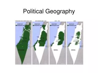
Defining States: Problems • Korea • Since 1945 the Korean Peninsula has been divided; since 1953 a four kilometer demilitarized zone has divided North and South Korea. • Since the 1990s there have been a number of small attempts to reconcile. In 2000 the Presidents of North and South Korea met for the first time. • China & Taiwan • In 1949, during the Chinese Civil War, the government of China retreated to the island of Taiwan. When they lost, and the People’s Republic of China was created, Taiwan remained as holdout. • Taiwan was a one-party state under martial law until 1987. Today there is a Taiwanese independence movement – which is strongly resisted both by the People’s Republic and by some Taiwanese. • Western Sahara • The former Spanish Sahara. • Claimed by more than one nation. Sources: http://commons.wikimedia.org/wiki/Image:Map_korea_without_labels.png; http://usinfo.state.gov/eap/east_asia_pacific/chinese_human_smuggling/smuggling_maps/china_map.html
Western Sahara’s Wall Sources: http://en.wikipedia.org/wiki/Image:Westernsaharamap.png; http://maps.google.com/?t=h&ie=UTF8&om=1&ll=21.348823,-16.203488&spn=0.003727,0.005246; http://news.bbc.co.uk/2/hi/in_pictures/4588982.stm
There is only one large piece of land anywhere on earth that is not controlled by a state – Antarctica. At least until 2041, all territorial claims here have been suspended – but they have not been abandoned. The World is Almost All States Note overlapping claims
Claims to the Arctic • Oil and natural gas, as well as coal, copper, gold, iron, nickel, tungsten, uraniumare all found in the Arctic. • As technology and climate change make this area more accessible, more nations are trying to assert their claims to the region (including offshore regions).
The Rise of States • Nations have existed from time immemorial. • States, in some sense at least, have existed for thousands of years. • "City-States" in Mesopotamia and Greece. • Early political empires (Agade, Egypt, Zhou, Rome, etc.) • The modern concept of the nation-state only dates back to Europe in the 17th-19th centuries. • As recently as 1950 there were only about 50 internationally recognized independent countries; now there are nearly 200 (and more may be coming!)
A colony is a territory that is legally joined to a sovereign state, and is not completely self-governing. The sovereign state may control the colony completely, or may just control some aspects (defense, foreign affairs). During the last 500 years, colonies were planted by European countries over much of the world. Why did Europe establish colonies? GOD! (cultural imperialism) GOLD! (profit, resources) GLORY! (status) The largest colonial powers were England, France and Spain. Colonial policies varied from integration to pure exploitation. Decolonization – sometimes a violent process – ended the colonial era in the 20th century. There are only a few colonies today – mostly islands. Colonies
Physical Characteristics of States • Size • States vary greatly in size, from enormous to microstates: • The Russian Federation – 6,592,850 mi2 (17,075,400 km2). • Vatican City 109 acres (44 hectares, or about .17 mi2). • Shape • States have five basic shapes: • ELONGATED (long, narrow shape – may cause a portion of a country to be isolated or vulnerable). • FRAGMENTED (discontinuous territory – mostly island nations today). • PERFORATED (one state completely surrounds another – an "enclave"). • PRORUPT ["Panhandle"] (projecting extension – usually created either to prevent other states from contact, or to access resources). • COMPACT (considered ideal – theoretically very efficient). #TERRITORIALMORPHOLOGY
Compact Prorupt Elongated Fragmented Perforated Shapes of States
Decent farmland is limited in this region, and under the Soviets control of the Fergana Valley was divided among Kyrgyzstan, Tajikistan & Uzbekistan – which were all part of the USSR. Today all three are independent countries, and have to deal with hideously complex borders. Enclaves & Perforations: The Fergana Valley
Fergana Valley: Perforations & Enclaves Source http://www.cominganarchy.com/wordpress/wp-content/old_uploads/ferganaenclaves.jpg
Landlocked states have no direct access to the sea – so their access to international trade is severely limited. Landlocked states have to depend on the cooperation of their neighbors. Landlocked States
Boundaries • Until modern times, most countries were separated by frontiers – zones where no state has political control. • Boundaries may be either physical or cultural. • PHYSICAL BOUNDARIES • Physical boundaries should be easily distinguished, permanent, and (ideally) hard to cross. • Examples: Mountains, deserts, bodies of water. • CULTURAL BOUNDARIES • Cultural boundaries also ought to be easily distinguished, and permanent – but that is not always possible. • Examples: Ethnic (language, religion), geometric • The best boundaries are those everyone accepts – regardless of how they are drawn!
Water Desert Mountains Physical Boundaries
Unless they are truly impassable – and with modern technology, nothingis – physical boundaries only work well if everyone agrees on them. Defining boundaries is often contentious. Water boundaries have special problems: Rivers shift courses. Oceans don’t have obvious boundaries – and nations can claim large areas for security or economic reasons. Problems With Physical Boundaries "In the exclusive economic zone, the coastal State has sovereign rights for the purpose of exploring and exploiting, conserving and managing the natural resources, whether living or non-living ... The exclusive economic zone shall not extend beyond 200 nautical miles …" Convention on the Law of the Sea, Part V Sources: http://www.hri.org/docs/LOS/part5-1.html; http://earthguide.ucsd.edu/fishes/kinds/images/eez_us.jpg
UN Convention on the Law of the Sea Keep in mind – the US has not signed the Convention (though it helped negotiate it).
Cultural Boundaries • ETHNIC (religious & linguistic) • Boundaries drawn on the basis of cultural characteristics. • No country on earth has perfect cultural boundaries – because no country is a perfect nation-state. • GEOMETRIC ("mathematical") • Arbitrary lines drawn on the map, without regard to physical or other cultural factors. • Usually drawn before an area has a significant population.
Irredentism • Irredenta are regions that are culturally or historically related to one country, but ruled by another country. • Ethnic enclaves can cause friction both within countries and between countries. • In most of the world national boundaries do not correspond to ethnic boundaries.
Other Kinds of Boundaries? • RELICT BOUNDARIES • Former boundaries, which may no longer have much (or any) legal standing, but are still visible in the landscape. • Examples: Wales-England; Spain-Britain (the 42º N North American boundary – now the California-Oregon boundary). • BUFFER STATES & SATELLITE STATES • Independent states used by major powers to reduce mutual conflict ("satellite" states are dominated by a major power – but are technically independent). • Examples: Eastern Europe during the Cold War; Mongolia; Nepal.
A Relict Boundary: Hadrian’s Wall • In the year 122 the Roman Empire built a fortification across the north of England, dividing the Empire’s territory from that of the "barbarian" Scots to the north. • The Emperor Hadrian’s Wall was the most heavily fortified border in the Empire, and helped establish the boundaries of England and Scotland – but it’s not the border today. • Today what’s left of the Wall is entirely within England.
Buffers • All of the highlighted countries have been considered "buffer states": • Eastern Europe (between the USSR and US allies in Western Europe). • Mongolia (between China and Russia) • Nepal and Bhutan (between India and China) • Jordan (between Saudi Arabia and Israel)
Democratic, Autocratic and “Anocratic” States • Democracy: Government by the people. • Autocracy: Government by the ruler(s). • Anocracy: Neither fully democratic nor autocratic.
Internal Organization of States • Unitary States: • Strong central government – country as a single "unit"; • Local governments have little or no power or responsibilities (except to implement central government policies); • Can be democratic, but often totalitarian, one-party; • Theoretically ideal for small, homogenous states, but many large states have been unitary. • Federal States: • Contractual arrangement divides power between central and local governments — "allocation of residual powers"; • May be "weak" or "strong"; • Theoretically large, multinational states, but an increasing number of states today are federal. • It can be hard to tell the difference between a strong federal state and weak unitary state!
Federal & Unitary States Federal States Unitary States
US Constitutional Limits on Federal Power "The powers not delegated to the United States by the Constitution, nor prohibited by it to the States, are reserved to the States respectively, or to the people." Tenth Amendment to the U.S. Constitution
US Constitutional Limits on State Power "No State shall enter into any Treaty, Alliance, or Confederation … coin Money … pass any … ex post facto Law … or grant any Title of Nobility. "No State shall, without the Consent of the Congress, lay any … Duties on Imports … "No State shall, without the Consent of the Congress … keep Troops, or Ships of War in time of Peace, enter into any Agreement or Compact with another State, or with a foreign Power, or engage in War, unless actually invaded, or in such imminent Danger as will not admit of delay." Excerpts from Article 1, Section 10, U.S. Constitution
Electoral Geography • In democracies (unitary or federal), there are many steps and many questions that have to be answered in determining how a state will be run: • Who votes? (Historical expansion of suffrage) • Who can be elected? (Eligibility – citizenship, party membership, poll tax, etc.) • Who wins? • Majority (or plurality) vs. run-off. • Proportional vs. winner-take-all. • How are electoral district boundaries drawn?
The Gerrymander • "...the deliberate manipulation of political district boundaries to achieve a particular electoral outcome." This originally appeared in 1812 in The Boston Messenger, and is supposed to have been drawn by the painter Gilbert Stuart. See http://historytogo.utah.gov/hmgerry.html
2010 North Carolina Congressional Districts District 12 Source: http://nationalatlas.gov/printable/congress.html
Gerrymander Species • By law, Congressional district boundaries must be "contiguous and compact," have roughly equal populations, and can’t be drawn solely to benefit one political party. They can be drawn on the basis of "shared interests." • There are three types of gerrymander: • Wasted vote: Dilute opposition so that it can’t win ("cracking"). • Excess vote: Concentrate opposition so that it can only win a few districts ("packing"). • Stacked vote: Connecting and concentrating groups.
Blue is gerrymandering. District 1 is stacked (and packed).(blue communities that are widely separated are connected). District 2 is packed (red communities are concentrated in one district). District 3 is cracked (red communities are "diluted" in a sea of blue communities). The result? Blue should always win two districts, red one. Cracking, Packing and Stacking 1 2 3
But Are All Funny-Looking Districts Gerrymanders? • "[U]nconstitutional discrimination occurs only when the electoral system is arranged in a manner that will consistently degrade a voter's or a group of voters' influence on the political process as a whole...[S]uch a finding of unconstitutionality must be supported by evidence of continuedfrustration of the will of a majority of voters of a fair chance to influence the political process." (U.S. Supreme Court, Davis v. Bandemer 1986) • Gerrymanders are illegal – but just because an electoral district is weird looking – even if it gives one group or political party an advantage – it isn’t necessarily illegal.
Not Gerrymanders Source (10-24-01): http://www.fairvote.org/redistricting/irregularWest.htm
Not Gerrymanders?!? Source (10-24-01): http://www.fairvote.org/redistricting/irregularTX.htm
California’s Congressional Districts Districts in California in 2010 were determined by the Citizens Redistricting Commission. California has 53 Representatives. Source: http://www.joincalifornia.com/page/8; See also http://wedrawthelines.ca.gov/maps-final-draft-congressional-districts.html
San Diego’s Congressional Districts Adapted from: http://swdb.berkeley.edu/gis/gis2011/; see also http://wedrawthelines.ca.gov/downloads/meeting_handouts_072011/viz_20110728_q2_cd_finaldraft_kmz.kmz
Texas’s Reapportionment: 2001 vs. 2003 2001 2003 In 2004 the Supreme Court (in Vieth v. Jubelirer); 2006 Supreme Court decision in League of United Latin American Citizens v. Perry determined that states may redistrict whenever they like. All but one of these districts was found acceptable – not gerrymanders. Source: http://www.lib.utexas.edu/maps/texas.html
Focus on Texas’ 25th District Source: http://filipspagnoli.wordpress.com/2011/05/10/human-rights-maps-134-gerrymandering/
The 2012 Presidential Election: by State & by County Source: http://www-personal.umich.edu/~mejn/election/2012/
The 2012 Presidential Election: State Population Cartogram Source: http://www-personal.umich.edu/~mejn/election/2012/