Download
1 / 34
360 likes | 539 Vues
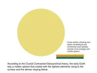
Cross-section showing rock layers correlating to the continental crust (yellow), oceanic crust (orange) and mantle (green).

E N D
Cross-section showing rock layers correlating to the continental crust (yellow), oceanic crust (orange) and mantle (green). According to the Crustal Contraction/Geosynclinal theory, the early Earth was a molten sphere that cooled with the lightest elements rising to the surface and the denser staying below.
Early on, as the crust cooled, the surface began to crack as it contracted. These kinds of cracks usually form three-pointed cracks that form six or five sided pieces – think of mud-cracks.
As the crust pulled away from the cracks, new rock (oceanic crust) appears below it. The crust wrinkles near the edges, similar to an apple that is drying out exposing white flesh below. This is why it is sometimes called the “Dried Apple Theory”.
When the Earth becomes cool enough (remember it was a molten ball), water condenses from steam out of the atmosphere and forms shallow ocean basins where the oceanic crust is exposed – the continental rock continues to cool and contract, making the oceans wider and the mountains more extensive.
Over time, the pieces of crust separate completely into “Continents” with shallow seas near the coastlines but deep, flat ocean basins below.
Finally, we see the world as it is today…sort of. Mountain belts along the edges of continents…mostly. Shallow continental shelves made from eroded sediment with deep flat ocean “basins” – we thought. It sort of made sense but parts of it didn’t really fit what we saw in the world. And why were the outlines of some continents so similar??
Two men who were bothered by this: Eduard Suess (top) & Alfred Wegener (right). Both made observations that began to put a few “cracks” in the “Dried Apple Theory”.
Fossils like Glossopteris were used by Suess to show that it was likely that all the southern continents had all been part of one landmass he called “Gondwanaland”. He also noted the appearance of a fresh water reptile “Mesosaurus” in two distant continents.
Lystrosaurus – below – was a short-legged therapsid, a mammal like reptile. Not the sort of animal you can imagine swimming across the oceans. Glossopteris – above – was a tree fern that would have had limited distribution similar to ferns and mushrooms today because they reproduced by spores.
Summary of four organism found scattered between the Gondwanaland continents proposed by Suess. Cynognathus was similar to Lystrosaurus . This was how Suess proposed they were originally situated 250 million years ago.
If Suess’ ideas about Gonwanaland were correct, you would expect to find structures that match across the continents when they are put back “together”. The analogy is a newpaper that has been torn down the middle but when you put them back together, you can read across the two halves and know that they belonged together. So did the continents have that relationship when put back together?
Wegener checked out Suess’ observations in the southern continents and also found them in the northern continents like this example from North America and Europe. Wegener began to suspect that around 250 million years ago, all the present continents were together in one “Supercontinent” that he called “Pangaea” or “All-Earth”.
Wegener also showed that the paleoclimates made sense of you arranged the continents 250 million years ago into the position suggested by the rocks, structures and fossils.
The other bit of the puzzle that Wegener found that made no sense in light of the Dried Apple theory as the positions of glaciers in the ancient earth. Movements seemed to go from the sea onto land but it was known that they only go from land to the water. Putting the continents into the Pangaea position solves that problem.
Harry Hess took Wegener ‘s work and continued looking for an answer to how it could all work. He mapped the Pacific Ocean for the U.S. Navy during World War II to use for submarine warfare – and to find evidence for Continental Drift.
trenches mid-ocean ridges Mapping of the ocean floors had shown that next to the continents, there were often deep trenches which were sometimes found along oceanic island chains as well. Running down the centers and edges of ocean basins were mountain-range-like ridges that were heavily fractured. None of this fit the idea of crustal contraction.
Hess worked in the Pacific Ocean but the Atlantic has a very well developed mid-ocean ridge with few trenches – the only significant trench is along the front of the Caribbean Sea. It was determined that these mid-ocean ridges were actually “spreading centers” building new crust at the centers and pushing away on each side.
This is the process that creates thermal convection cells that move the plates and create the mid-ocean ridges. As the material sinks back down, it pulls the crust down with it and it melts, creating a “subduction trench”. This was Hess’s hypothesis for how much of the plate movement occurs. Convection currents in a pan of warming solid showing fracturing and rising of warm material (brightest) and sinking of cooler material (darker).
The big picture of plate movement and boundary relationships.
The major plate boundaries: • Sea-floor spreading – a “divergent” boundary. Divergent boundaries include all spreading centers and rift zones. These are pushing away from each other. • Subduction zones are the major “convergent” boundaries. They may continent to continent (creating mountains), ocean crust to continent (creating volcanic mountain chains) or ocean crust to ocean crust (creating volcanic “island arcs”). These are pushing towards each other. • Transform faults occur in spreading centers as the ridge is offset by the movement of the Earth and on sliding fault zones like the San Andreas Fault in California. These are sliding past each other.
In addition to just spreading, the mid-ocean ridge also showed changes in the orientation of the magnetic field. Each side of the ridge has mirror-image changes.
Major changes in polarity over the last 4.5 million years – fairly “recent” times
Magnetic fields flip often in the geologic record but not at any regular interval. The graph to the left shows changes over the last 158 million years. The models on the right show a normal field and maybe how the field looks as it is changing.
“Hot spots” or “mantle plumes” rise from deep below the crust and pump magma into the crust. These might last for tens of millions of years like this one that created the Hawaiian Islands.
The spreading of crust also occurs on the land when “hot spots” rise up under them and split the thick crust. This is occurring in Africa now with East African Rift Zone beginning to from a sea-floor. The Red Sea and Gulf of Aden are already small sea-floor spreading centers as is the Gulf of California between Mexico and Baja California.
Uplift of land in the rift zone (yellow-red areas, left) and earthquake (red dots) and volcanic activity (green) to the right.
Earthquake activity is associated with all plate boundaries. The shallow ones in blue mark the spreading centers and areas with intermediate and deep earthquakes mark subduction zones.
Volcanic activity is mostly associated with subduction trenches though occasionally there is some on ridges and also from “hot spots” that might appear anywhere.
Current positions and make up of the major plates of the Earth
The Earth as it may look in 50 million years if plate continue to move as they have been.