Download
1 / 1
10 likes | 122 Vues
CLOUD MASK AND QUALITY CONTROL FOR SST WITHIN THE ADVANCED CLEAR SKY PROCESSOR FOR OCEANS (ACSPO ) A. Ignatov 1 , B. Petrenko1,2 1 NOAA/NESDIS/STAR, 2 IM Systems Group, Inc. 1. Requirements:

E N D
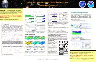
CLOUD MASK AND QUALITY CONTROL FOR SST WITHIN THE ADVANCED CLEAR SKY PROCESSOR FOR OCEANS (ACSPO) A. Ignatov1, B. Petrenko1,2 1NOAA/NESDIS/STAR, 2IM Systems Group, Inc. • 1. Requirements: • The Advanced Clear-Sky Processor for Oceans (ACSPO) is developed at NESDIS to generate clear sky brightness temperatures (BT), aerosol and Sea Surface Temperature (SST) from AVHRR-like measurements at a pixel resolution. • The purpose of the ACSPO Quality Control (QC) is to screen out the pixels, not usable for clear-sky products while preserving as many useful pixels as possible. Since the major part of pixel contaminations is caused by clouds, QC can be treated as an efficient cloud masking algorithm. QC extensively uses online clear-sky radiative transfer simulations and real-time NWP information. • In addition to QC, the future ACSPO versions will include the Cloud Mask (CM) module, which will screen out clouds using only static ancillary data. This will enhance robustness and stability of the cloud masking process in case if the NWP information is unavailable [1]. • 2. The Features of ACSPO • The ACSPO QC has some unique features, which make it different from the majority of existing cloud masking algorithms [4]. • 2.1. Emphasis on On-line Clear-Sky RTM simulations • Instead of exploiting cloud emission and reflection properties, ACSPO QC makes an emphasis on more accurate online clear-sky simulations. ACSPO incorporates the Community Radiative Transfer Model, which simulates clear-sky BT from 0.25o High Resolution-Blended SST (OISST) [2]) and 6-hour 1o NCEP GFS upper air fields [3]. Anomalies DBT=Observed BT- CRTM BT and DSST=Retrieved BT – OISST are used as input for QC. • 2.2. Accounting for Biases in Observed BT and Retrieved SST • Calibration and algorithmic factors cause biases in DBTand DSST, which, in turn, can affect the QC performance and stability. To avoid this, ASCPO estimates the biases online, prior to and independently from QC as positions of maximums of anomaly histograms, accumulated over all ocean pixels. QC accounts for bias estimates, improving temporal stability and cross-platform consistency of retrieved SST [1,4]. • Fig. 1 shows the histograms of DSST for four AVHRR-carrying platforms. Though the positions of peaks are different, especially for NOAA-16, in all cases the histograms preserve a quasi-Gaussian shape. 2.3. Detecting Ambient Cloudiness ASPO QC includes two sequential tests, which use DSST as a quality predictor. The Static SST test initially separates all ocean pixels into “clear-sky” and “cloudy” clusters by detecting unrealistically cold DSSTvalues. The Adaptive SST test refines the initial clasterization based on statistics of DSSTover“clear-sky” and “cloudy” pixels in the neighborhood of every “clear-sky” pixel. This approach allows to avoid excessively strict restrictions on “realistic” DSSTvalues and at the same time to reject ambient clouds, typically surrounding cloudy systems. 2.4. Advanced Detection of Subpixel Clouds Existing cloud masking algorithms typically include “spatial uniformity” tests, which detect subpixel cloudiness by elevated spatial variability of observed BT. The typical drawback of this kind of tests is that intensive thermal fronts in the ocean can be misclassified as clouds. In the ACSPO QC the Uniformity test has the following peculiarities: - it applies to retrieved SST rather than to observed BT; this allows direct addressing cloud contaminations in the retrieved variable. - The retrieved SST field is passed through the 2D median filter and the test applies to the difference retrieved SST – median (retrieved SST). This improves discrimination between thermal fronts and random subpixel clouds. - In the daytime detection of subpixel clouds further improves with the BT/Reflectance Cross-Correlation test. This test enhances detection of subpixel clouds detecting correlation of small negative SST variations with positive variations in Ch2 reflectance • 3. Applications • 3.1. AVHRR • 2.2. GOES-R ABI and MSG SEVIRI • 4. Future applications • 5. References • Petrenko, B., et al, 2009: AMS conference, Jan 11-15, 2009, Phoenix, AZ (poster JP1.12). • 2. Reynolds, R.W. et al., J. of Climate, 20, 5473–5496 • 3. http://nomad3.ncep.noaa.gov/pub/gfs/rotating/ • 4. Petrenko, B. et al., 2010: Clear-sky mask for ACSPO, JTech-A, in review. • 5. Heidinger A., 2004: CLAVRx ATBD, NOAA/NESDIS/STAR. • 6. OS&I SAF SST Product User Manual, v2.1, Nov 2009. • 7. Shabanov N. et al, 2009: AMS Conf, Jan 11-15, 2009, Phoenix, AZ (poster JP1.12). Fig. 2. Composite map of DSST from nighttime METOP A measurements on August 1, 2009 over the Gulf of Mexico. a) after Static SST test b) after Static and Adaptive SST tests ACSPO Fig. 4. The MetOp-A FRAC images of the Gulf of Mexico obtained from ACSPO and O&SI SAF SST product. The ACSPO is currently used in OSDPD for operational processing of AVHRR data from the platforms NOAA-16, -17, -18,-19 and MetOp-A. Comparison with other world-class cloud mask products (CLAVRx [5]; O&SI SAF [6]) shows similar or better performance of the ACSPO cloud masking algorithm. O&SI SAF Fig. 3. SST field east off the South America as observed with MetOp-A AVHRR on August 1, 2008 (night) and processed with CLAVRx [5] BT uniformity tests (a) and with ASPO SST Uniformity test (b) Fig. 5. The example of the full disk SST and cloud distributions generated with ACSPO from MSG2 SEVIRI measurements 12:30 UTC, June 6 2008. The ACSPO will be also used for processing data of the Advanced Baseline Imager (ABI) onboard the GOES-R satellite. The GOES-R SST and QC algorithms are modified from AVHRR-ACSPO using MSG2 SEVIRI as a proxy [7]. Fig. 1. Histograms of DSST over “clear” pixels for 4 platforms, carrying AVHRR sensors, August 1-7, 2008 Another potential ACSPO application is the Visible Infrared Imager Radiometer Suite (VIIRS) onboard the National Polar-orbiting Operational Environmental Satellite System (NPOESS)