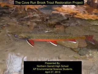
Advanced Fusion Techniques for Multi-Sensor Data Integration in Object Classification
This project explores innovative fusion techniques combining spatial and spectral data to enhance object classification. Utilizing image pairs of varying scales and modalities, we propose unsupervised classification methods that incorporate local spatial information with spectral data. We address image interpolation challenges, particularly content loss from resampling. Future work will integrate hyperspectral data and LIDAR imagery, accounting for atmospheric effects like partial attenuation. Our advancements offer significant operational benefits, including improved analysis and reduced analyst workload.

Advanced Fusion Techniques for Multi-Sensor Data Integration in Object Classification
E N D
Presentation Transcript
Feature Based Fusion of Multi-Sensor DataWest State University PI: John A. DoePortfolio/Operational Problem: HSI/Fusion Abstract: Several fusion techniques utilizing a combination of spatial and spectral information are being examined. We make use of image pairs of different scales, modalities, and textures. Under the overarching goal of improving object classification, we propose unsupervised classification schemes reliant on different filters and Matrices for capturing local spatial information to be used in conjunction with spectral data. We additionally address the problem of image interpolation by identifying specific instances of content loss due to resampling. Continued efforts in this direction are to include hypersepctral data and LIDAR imagery as a means of gaining finer resolution both spectrally and spatially. Future efforts will include the consideration of atmospheric effects such as partial attenuation and obscuration that is inconsistent from one image to the next. Logo or graphic Accomplishments/Results: • Developed a new method for resampling imagery that reduces mixing of pixels • Developed and tested new method that uses texture information from a high resolution image from one platform and low resolution multispectral imagery from another platform. • A test application has begun that uses a course to fine strategy to search for suspicious sites. Potential Operational Impact • Allow richer analysis from multiple data sources. • Reduce analyst time needed to conduct search and site analysis in support of counterproliferation mission. • Collaboration • Dr. Jane Doe at the East State Univ • discussing related project with DARPA/IARPA • commercial application possible with ABC Research Corp. • Future Efforts • Incorporate digital elevation maps and LIDAR data to enhance fusion of multiple images. • Consideration of atmospheric effects such as partial attenuation and obscuration that is inconsistent from one image to the next. • Contact Info • doeja@wsu.edu • 123-456-7899