Download
1 / 17
180 likes | 330 Vues
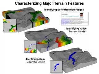
Characterizing Major Terrain Features. Identifying Extended High Ridges. Identifying Valley Bottom Lands. Identifying Dam Reservoir Extent. 1) SCAN Elevation Average Ignore -1 Within 3 Circle For Elev_smooth3. 3D Lattice Display with 2D projection. Elevation. Elev_smooth3. 2600.

E N D
Characterizing Major Terrain Features Identifying Extended High Ridges Identifying Valley Bottom Lands Identifying Dam Reservoir Extent
1) SCANElevation Average Ignore -1 Within 3 Circle For Elev_smooth3 3D Lattice Display with 2D projection Elevation Elev_smooth3 2600 2300 3D Grid Display
2) DRAINEntire Over Elev_smooth3 Simply Steepest For Flowmap 3) RENUMBER Flowmap Assigning 0 To 2 Thru 3000 For Raw_ridges 4) SCANRaw_ridges Majority Ignore -1 Within 1 Circle For Ridges
6) COMPOSITE Individual_ridges with Elevation minimum ignore -1 for Ridges_minElev 5) CLUMP Ridgesat 1 diagonally FOR Individual_ridges Ridges 2424 Ridges above Mean Elevation of 2440 7) RENUMBER Ridges_minElev assigning 0 to 0 thru 2440 assigning 1 to 2440 thru 10000 for High_ridges
9) RENUMBER Slopemap Assigning 1 To 0 Thru 5 Assigning 0 To 5 Thru 100 For Gentle_slopes 10) SCANGentle_slopes Majority Ignore -1 Within 1 Circle For Gentle_slopes2 8) SLOPE Elevation Fitted For Slopemap 35% 5 0% 11) SPREAD High_ridges To 100 Thru Gentle_slopes2 Simply For Expanded_ridges
1) CALCULATE ((Elev_S – 2564) * -1) For Inverted_ElevS3 3) RENUMBER Flow_inverted Assigning 0 TO 1 Thru 80 Assigning 1 TO 80 Thru 1000 For RawRidges_Inverted 4) SCANRawRidges_inverted Majority Ignore -1 Within 1 Circle For Ridges_Inverted 2) DRAINEntire Over Inverted_Elev_S3 Simply Steepest For Flow_inverted 5) CLUMPRidges_Inverted At 1 Diagonally For IndRidges_Inverted 6) CompositeIndRidges_Inverted With Elevation Minimum Ignore -1 For Ridges_minElev_Inverted 7) RENUMBER Ridges_minElev_Inverted Assigning 0 TO 0 Thru 2440 Assigning 1 TO 2440 Thru 10000 For High_ridges_inverted 8) SPREAD High_ridges_inverted To 100 Thru Gentle_slopes2 Simply For Expanded_ridges_inverted
Extended High Ridges …using a Standard Elevation Surface …similar results Extended High Ridges …using an Inverted Elevation Surface
2) RENUMBER Slopemap Assigning 1 To 0 Thru 6 Assigning 0 To 6 Thru 100 For Gentle_slopes 3) SCANGentle_slopes Majority Ignore -1 Within 1 Circle For Gentle_slopes2 1) SLOPE Elev_smooth3 Fitted For Slopemap 35% 5 0% 4) SPREAD WaterTo 36 Thru Gentle_slopes2 Simply For Valley_bottoms
4) RENUMBER Elev_Dam _clumps Assigning 0 To 1 Thru 2 Assigning 2383 To 3 Assigning 2390 To 4 Thru 7 For Dam_lake 1) RENUMBER Elevation Assigning 2383 To 0 Thru 2383 Assigning 0 To 2383 Thru 10000 For Elev_2383 3) CLUMPElev_dam At 1 Orthogonally For Elev_dam_clumps 2) COVER Elev_2383 With Dam_2390 For Elev_dam 5) COVER Elevation With Dam_Lake For Elev_dam_lake
Characterizing Major Terrain Features Identifying Extended High Ridges …could include aspect and distance to road in refining best ridges for Wind Power development— how? Identifying Valley Bottom Lands …could include vegetation type in the extended riparian zone— how? Identifying Dam Reservoir Extent …could calculate reservoir volume capacity at various surface water heights— how?
Just for fun …you’re having fun, right? Let’s compare the effect of changing a bit of model logic… The method of determining ridge elevation from— Minimum Elevation for each candidate ridge versus Average Elevation for each candidate ridge …in determining high ridges
6) COMPOSITE Individual_ridges with Elevation minimum ignore -1 for Ridges_minElev 5) CLUMP Ridgesat 1 diagonally FOR Individual_ridges Ridges 2424 Ridges above Mean Elevation of 2440 7) RENUMBER Ridges_minElev assigning 0 to 0 thru 2440 assigning 1 to 2440 thru 10000 for High_ridges
9) RENUMBER Slopemap Assigning 1 To 0 Thru 5 Assigning 0 To 5 Thru 100 For Gentle_slopes 10) SCANGentle_slopes Majority Ignore -1 Within 1 Circle For Gentle_slopes2 8) SLOPE Elevation Fitted For Slopemap 35% 5 0% 11) SPREAD High_ridges To 100 Thru Gentle_slopes2 Simply For Expanded_ridges
6) COMPOSITE Individual_ridges with Elevation average ignore -1 for Ridges_avgElev 5) CLUMP Ridgesat 1 diagonally for Individual_ridges Ridges 2424 Ridges above Mean Elevation of 2440 7) RENUMBER Ridges_avgElev assigning 0 to 0 thru 2440 assigning 1 to 2440 thru 10000 for High_ridges
9) RENUMBER Slopemap assigning 1 to 0 thru 5 assigning 0 to 5 thru 100 for Gentle_slopes 10) SCANGentle_slopes majority ignore -1 within 1 circle for Gentle_slopes2 8) SLOPE Elevation fitted for Slopemap 35% 5 0% 11) SPREAD High_ridges to 100 thru Gentle_slopes2 simply for Expanded_ridges
Extended Ridges based on Minimum Elevation …domain expertise is needed to refine any GIS procedure or model Extended Ridges based on Average Elevation
More “fun” …identifying upland, low land and side slopes RENUMBERUpland_ridges assigning 0 to 0 thru 99 assigning 2 to 99 thru 100 for Not_uplandRidge 2 Not an upland ridge or “Upland Slope” Upland Ridges ComputeNot_uplandRidge plus Not_valleyBottom for Combined_slopes Combined Slopes 1 Not a valley bottom or “Toe Slope” RENUMBERValley_bottoms assigning 0 to 0 thru 35 assigning 1 to 35 thru 36 for Not_valleyBottom Valley Bottoms