Alabama GIS Council Meeting Agenda and Subcommittee Updates
310 likes | 425 Vues
Explore the meeting agenda and updates from various GIS subcommittees for Alabama Geographic Information Executive Council. Topics include imagery, data standards, education, outreach, communication, and more.

Alabama GIS Council Meeting Agenda and Subcommittee Updates
E N D
Presentation Transcript
Alabama Geographic Information Executive Council Spencer Collier Chairman June 19, 2012
Agenda • Welcome • Introduction of Members and Guests • Approval of January 25, 2012 Minutes • GIS Advisory Committee/Subcommittees Update • GIS Website Discussion • GIS Inventory Tool • Statewide GIS Goals • Other Business • Next Meeting • Adjourn
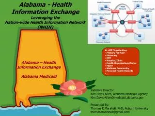
Alabama GIS Council Coordination Structure
Imagery/LiDAR Subcommittee • Chairman John Russell, ALDOT Assistant Location Engineer • The Aerial Imagery Business Plan has been completed (Posted on the website gis.alabama.gov)
Imagery/LiDAR Subcommittee • Objectives from Business Plan • Distribute USGS photography and LiDAR specifications for review to stakeholders • Modify existing ADOR Mapping Guidelines and Specifications to reflect the updated specifications • Outreach to Federal, State, and Local Governments to communicate the Business Plan … determine possible funding sources for future partnerships • Establish policies and strategies which emphasize cooperation and coordination at all levels of government and other stakeholders in order to maximize the cost efficiency • Develop acquisition plans for Imagery and LIDAR for the 2012-2013 flying season • Identify and develop funding sources for project implementation and long-term maintenance
Data Subcommittee • Chairman Michael Hughes, GIS Manager Franklin County and The Northwest Alabama GIS Consortium • Co-Chair Dr. Sandy Ebersole, Geological Survey of Alabama • Framework Data • Data Standards • Data Access • Metadata
Data Subcommittee • Concentrate activities on the goals of the GIS Executive Council • Inventory current GIS data, applications, and services • Virtual Alabama is the key resource for data inventory • Authoritative sources must be identified and used • Primary Coordination Goals of framework data layers for 2012 • Aerial Imagery • Parcel Data • Road Centerlines • Geocoded Address • Identify/Document statewide data standards from authoritative sources in order to establish statewide data standards so that coordination/ collaboration is improved • Identify the authoritative sources for the 7 framework data layers down to the local level
Education & Outreach Subcommittee • Chairman Lynn Ford, GIS Coordinator ADEM • Create GIS Education Opportunities • Stakeholder workshop program as a vital part of the statewide Education & Outreach Subcommittee (annually) • Conduct outreach and education programs specifically targeted at local level authorities and stakeholders (e.g., economic development, local schools, county engineering, law enforcement, public utilities, and emergency management). Provide outreach programs specifically designed to inform citizenry about GIS issues and opportunities. • Organize and host the state GIS conference and encourage participation in GIS Day events
Education & Outreach Subcommittee • Participate in non-GIS events in order to reach out to non-GIS professionals • 2012 Alabama Water Resources Conference and AWRA Symposium • Identify outreach opportunities… • Conduct meetings on lessons-learned and best practices (and pitfalls) related to GIS data, applications, services, and professional development • Establish awards and recognition for GIS success stories around the State • Emphasize the benefits of using GIS for specific problem-solving applications
Communications Subcommittee • Chairman David Palmer, Franklin County Engineer and Director of The Northwest Alabama GIS Consortium (Alabama Association of County Engineers Council Representative) • Establish a unified “Umbrella” for GIS in Alabama (gis.alabama.gov) • Reinforce existing and emerging brand names under this “Umbrella” • Virtual Alabama • NHD-WET • Showcase geospatial best practices and success stories • Build support from elected officials and others for the Alabama Geospatial Strategic Plan • Establish awards and recognition for GIS success stories around the State • Emphasize the benefits of using GIS for specific problem-solving applications
Alabama GIS Council Coordination Structure Pool Resources Economies of Scale Standards Framework Data Data Standards Data Access Metadata Workshops Training Classes Inventories External focus Collaboration Workshops Inventories Internal focus
Virtual Alabama by the numbers… • 32,160 Total Users • 139 Average Users Daily • 1074 Separate Alabama Government Agencies Using Virtual Alabama • 11,152,981 Total Virtual Alabama Hits in April
Long-term Goal • To provide a central location for the storage and searching of geospatial metadata records for the State of Alabama
Customer Wishes • Central, simple system for storage and searching of geospatial data assets
Fulfilling Customer Needs • Simpler than FGDC complete metadata standard • Compliance with the NSGIC data model • Capable of being harvested by the national Geospatial One-Stop • Upload of data or linking to web services for immediate viewing in the VA Web Portal
Strengths and Advantages • Single sign-on system containing over 32,000 users representing over 1,500 agencies • Simple, easy-to-use interface • System capable of being extended to meet community needs
Next Steps of Action • Provide training videos via web and demonstrations at public forums
Statewide GIS Goals • Statewide GIS Goals • Inventory current GIS data, applications, and services • Virtual Alabama is the key resource for data inventory • Authoritative sources must be identified and used • Leverage pooled resources (coordinate procurement) • Avoid unnecessary costs and duplications of effort • Improve decision-support for statewide issues (standards) • Statewide data standards need to be established to improve coordination • Standards from authoritative sources • Primary Coordination Goals of framework data layers for 2012 • Aerial Imagery • Parcel Data • Road Centerlines • Geocoded Addresses
Agenda • Other Business • Next Meeting • Adjourn