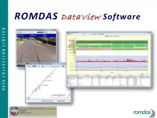
ROMDAS DataView Software
ROMDAS DataView Software. Save Time & Effort Processing Survey Data. C O M B I N E T H E S E T A S K S I N T O O N E P R O C E S S: Process video images for asset and condition data, Integrate multiple survey files, Present data in customised charts,

ROMDAS DataView Software
E N D
Presentation Transcript
Save Time & Effort ProcessingSurvey Data C O M B I N E T H E S E T A S K S I N T O O N E P R O C E S S: • Process video images for asset and condition data, • Integrate multiple survey files, • Present data in customised charts, • Create GIS maps with exportable layers
The ROMDAS DataViewModule Walk through the data integration process with the help of the Dataview Module
DataViewDatabase Objects- From NODEM Objects √ √ Table Query Constant Variable √ Interface/Data Play Query √ Model Grid √ Form Object Browser √ Report Batch √ Chart √ √ Navigator/ System Map Walker Sectioning √ √ Transformation Document RunT Var
Video Image Rating Add, remove or edit event keycodes on video logging images.
Video Image Rating • Reduce pressure on operators and increases accuracy when conducting video logging surveys • The image rating feature can also be used separately on each survey file without having to go through the rest of the data integration process
Video Image Rating Rate images from multiple cameras in the same easy process
Map Generation • Create GPS Maps from ROMDAS surveys • Combine with layers from other GIS sources
Map Generation Create distinct map layers for roads, video rating keycodes, Survey Events and Location Reference Points.
ROMDAS Data Integration Integrate multiple survey files into a single Access database. • Selective Integration Batch: Data Types, File(s), Folder(s) • Single Data Set Import
Data Presentation • Create custom graphs, charts and strip maps • Print to File or PDF
Data Presentation EASY VIEWING WITH ‘PLAY DATA’ FEATURE When using the ‘Play Data’ feature the video, GPS and graph displays are linked which allows for synchronised viewing. Click on a location on the Map, Video or Graph and have the all displays skip to that location.
Customisable Templates for DataView Custom templates can be designed to accommodate a number of data processing needs.
ROMDAS DataView For further information, please contact: info@romdas.com