Download
1 / 24
250 likes | 475 Vues
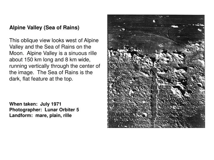
Alpine Valley (Sea of Rains) This oblique view looks west of Alpine Valley and the Sea of Rains on the Moon. Alpine Valley is a sinuous rille about 150 km long and 8 km wide, running vertically through the center of the image. The Sea of Rains is the dark, flat feature at the top.

E N D
Alpine Valley (Sea of Rains) This oblique view looks west of Alpine Valley and the Sea of Rains on the Moon. Alpine Valley is a sinuous rille about 150 km long and 8 km wide, running vertically through the center of the image. The Sea of Rains is the dark, flat feature at the top. When taken: July 1971 Photographer: Lunar Orbiter 5 Landform: mare, plain, rille
Lunar Maria The maria (singular = mare are the dark areas you see when looking at the Moon. These maria or “seas” make up about 16% of the Moon’s surface, but are 30% of the Earth-facing side. The Sea of Rains is the Moon’s largest, well-preserved basin (left photograph). The middle photograph shows the southeastern Sea of Rains with old, fractured terrain at the right and smoother, ridged mare terrain at center. Alpine Valley is a sinuous rille running vertically through the right photograph, and the Sea of Rains is the dark, flat feature at the top. Alpine Valley is about 150 km long and 8 km wide.
Sea of Rains This view looks south toward the Sea of Rains and Copernicus Crater (near the horizon). The crater near the center of the image is Pytheas (20 km in diameter). The Sea of Rains appears smooth due to the lava flows that covered the area following impacts. It is peppered with secondary crater chains and elongated craters. When taken: March 30, 1994 Photographer: Apollo 17 Location: 20°N, 22°W Landform: mare, lava flow, crater
Eratosthenes Crater This view of Eratosthenes Crater was photographed from Apollo 17 in orbit. Copernicus Crater is also visible to the far right. The mountains on the left are the start of the Apennine range. Diameter: 61 km Location: 14°N, 12°W
Copernicus Crater-Apollo 17 This view of Copernicus Crater is from Apollo 17 in orbit. The view is looking southwest. Age: 800 million years Diameter: 95 km Location: 9.5°N, 20°W
Copernicus Crater-Apollo 12 This view of Copernicus Crater is from Apollo 12 in orbit. The key-shaped feature below (south of) Copernicus is actually two craters: Fauth and Hauth. Age: 800 million years Diameter: 95 km Location: 9.5°N, 20°W
Copernicus Crater This image is interesting to compare with the “Copernicus Crater-Apollo 12” image.
Barringer Crater Barringer Crater is often called Meteor Crater, because it was the first crater on Earth recognized as an impact crater. The origin of this very well-preserved crater was a great controversy in the early 1900s. In the late 1950s, Eugene Shoemaker proved that Barringer Crater had been caused by a meteorite impact. Age: 49,000 years Diameter: 1.19 km Location: 35°02’N, 111°01’W (Winslow,Arizona)
Barringer Crater 2 Barringer Crater is an excellent example of a young, simple impact crater on Earth. It is the best-preserved crater in the US, because it is located in the arid desert of North-central Arizona where it is not subjected to strong erosive forces or hidden by Vegetation. The crater is more than 180m deep and the rim is raised nearly 50m Above ground level.
More about Barringer Crater The crater was formed when a 50m nickel/iron meteorite struck the desert at a speed of 11 km/s. Native Americans living in the region must have observed the impact and felt the tremendous shockwave that moved through the atmosphere. When fragments of the meteorite that caused Barringer Crater (the Canyon Diablo meteorite) were discovered, the crater’s impact origin became clear. Efforts to drill for the main body of the meteorite believed to be buried below the crater were unsuccessful. Layers of rocks have been overturned just outside the crater rim during ejection. Hummocks of material just beyond the rim are also remnants of the ejects blanket. This aerial view shows the dramatic appearance of the crater in the arid landscape.
Copernicus Crater Rays This image of Copernicus Crater shows rays especially well. Age: 800 million years Diameter: 95 km Location: 9.5°N, 20°W
Hadley Rille This photograph shows Hadley Rille and the surrounding region on the Moon. Hadley Rille is the sinuous depression running from left to right across the image. To the right are the Apennine Mountains (1-2 km high). Apollo 15 landed near the rightmost extension of the rille, near the top of the image. The large crater (30 km diameter) in the center of the image is Hadley C. When taken: August 14, 1967 Photographer: Lunar Orbiter 5 Location: 25°N, 3°E Landform: sinuous rille
Hadley Rille Close-Up Hadley Rille is a lava channel or a collapsed lava tube, covered in some places and uncovered in others, which carried molten lava. This high-resolution view shows the resulting V-shaped valley. The sides slope at about 20°, and the rille is 1 to 1.5 km from rim to rim. Apollo 15 landed about 2 km from the rim of Hadley Rille and explored it in detail. North is up. When taken: August 14, 1967 Photographer: Lunar Orbiter 5 Location: 25°N, 3°E Landform: sinuous rille
Bright-Rayed Crater This bright-rayed crater on the lunar farside was photographed from Apollo 13 during its pass around the Moon. The area is northeast of the Sea of the Edge. The dark circular features to the left of the rayed crater mark the floors of several large craters (Szilard, Maxwell, and Joliot), whose rims do not show up well because of high sun angle. Location: 45°N, 105°E
Mt. Saint Helens This spectacular, near-vertical photograph shows the 2548m Mt. Saint Helens volcano with its developing lava dome and surrounding pumice plain. The grayish area of the blast zone from the 1980 eruption extends northwest, north, and northeast of the volcano. North of the volcano lie three large lakes. When taken: September 1994 Photographer: space shuttle STS064 Location: 46°N, 122°W (Washington) Landform: volcano, lava flow, central peak
More about Mt. St. Helens On May 18, 1980, earthquakes preceded the eruption of Mt. Saint Helens, sending the north side of the mountain cascading toward Spirit Lake. This avalanche, the largest ever observed in the Western Hemisphere, weakened the magma chambers in the volcano. The result was an explosion that destroyed the surrounding forest in 5 seconds, buried the Toutle River valley to a depth of 300m and sent up a billowing cloud of ash and smoke. The lava dome, Visible in the center of the volcano crater, began to form in the early 1980s. Compare Mt. Saint Helens to Mauna Loa in the bottom left image and to Olympus Mons on Mars (bottom right image). Olympus Mons Volcano, Mars Mauna Loa, Hawaii
Mauna Loa Volcano This photograph of the “Big Island,” Hawaii, shows the summit and southeast portion of Mauna Loa, the largest mountain in the world in terms of volume. Two of its most active volcanic craters are visible: Mokuaweoweo Crater, the dark pit near the summit; and Kilauea Crater (large circular feature west of the steam cloud) on the southeastern flank of the volcano. Mauna Loa is a massive shield volcano whose summit rises 4170 m above sea level. The volcano’s lava is extremely fluid because of its low content of silica and gases and its very high temperature. During eruption the lava can flow more than 32 km before it cools and hardens. Old flows are visible in the photograph. Steam is blowing southwest from the main crater lake, Puu Oo, now filled with lava, which travels down the mountainside to the ocean through lava tubes and enters the ocean (steam cloud). When taken: September 1993 Photographer: space shuttle STS051 Location: 20°N, 156°W Landform: island, volcano, lava flow
Mars-Olympus Mons Volcano Olympus Mons, the largest known volcano in the Solar System, is 27 km high, over 600 km in diameter at the base, and is surrounded by a well-defined cliff (called a scarp) that is up to 6 km high. Lava flows drape over the scarp in places. The summit caldera (central depression) is almost 3 km deep and 25 km across. It probably formed from recurrent collapse when magma from eruptions drained from it. When released: January 1994 Photographer: Viking 1 orbiter Location: 20°N, 133°W Landform: volcano
More about Copernicus Bright blue tones suggest fresh material similar to Apollo 16 rocks and breccias. Mottled red-orange tones along the southern wall imply a higher abundance of iron-bearing materials. The image on the right is the Clementine image. The other two are Apollo images for comparison
Copernicus Crater-Clementine The left section of this Clementine image is a mosaic of the eastern half of Copernicus Crater in three different colors. It exaggerates small lunar color differences. The right section of the image is a mosaic of the same area in a single color, displayed as a mirror image to the other half for easy comparison. Age: 800 million years Diameter: 95 km Location: 9.5°N, 20°W
Orange Moon Dust These orange glassy fragments are the finest particles ever brought back from the Moon (about 0.02-0.045 mm). Apollo 17 astronauts brought the soil from the Taurus-Littrow landing site. Scientist-astronaut Jack Schmitt discovered The orange soil at Shorty Crater. The orange, black, and black-speckled grains are about the same size as particles of silt on Earth. When collected: December 12, 1972 Photographer: Apollo 17 Location: 20°N, 15°E Landform: rocks, soil
More about Orange Moon Dust The orange soil is like some samples brought back from the Apollo 11 (Sea of Tranquility) site, several hundred miles to the southwest. Like those samples, it is rich in titanium (8%) and iron oxide (22%). But unlike the Apollo 11 samples, the orange soil is unexplainably rich in zinc. The soil is probably of volcanic origin and not the product of meteorite impact. The bottom left photograph shows where the orange soil was Discovered near Shorty Crater at the Taurus-Littrow landing site on the Moon. The soil contains many orange volcanic-glass particles, giving it a distinctive color. The bottom right image highlights the differences in the minerals found in the rocks and soil in the Sea of Tranquility (left) and the orange soil in the Sea of Serenity at lower right. Dark purple areas at left center mark the Apollo 17 landing site, composed of explosive volcanic deposits.
Volcanic Ash When a volcano erupts, it can throw a lot of tiny rock fragments into the cloud that explodes from the top of the volcano. This ash may settle near the volcano or travel thousands of kilometers in the atmosphere. A volcano near Mammoth Lakes, CA, erupted 730,000 years ago, spreading ash as far as El Paso, TX and eastern Kansas and Nebraska. Color: varies Grains/crystals: very small (microscopic), angular Linearity: none