Download
1 / 77
770 likes | 800 Vues
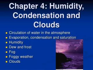
Learn about measuring humidity, condensation processes, cloud types, wind formation, air motions, frontal weather systems, and weather disturbances, examining how air moisture, cooling, and rising lead to cloud formation, precipitation, and various types of weather phenomena.

E N D
Chapter 19 Objectives: • Describe how humidity is measured. • Explain how condensation occurs. • List and describe the three basic types of clouds. • Discuss how winds form. • Explain vertical and horizontal air motions. • Describe frontal weather. • Describe long and short term weather disturbances. Fig. 19-CO, p.446
Moisture in the Air: • Warm air can hold more water vapor than cold air. • Humidity is the amount of water vapor in the air. Absolute humidity is the mass of wv in a given volume of air (g/cubic meter); relative humidity is the amount of wv in air relative to the maximum it can hold at a given temperature. • If you cool air with a given amount of wv, does RH increase or decrease? • When relative humidity reaches 100% the air is saturated (it has reached its dew point). Fig. 19-1, p.447
Cooling and Condensation: • Three atmospheric processes cool air to its dew point and cause condensation: radiation cooling, contact cooling and cooling of rising air. • Ice crystals condense on a window on a frosty morning, an example of contact cooling. Fig. 19-2, p.448
Most clouds form as rising air cools. The cooling causes invisible water vapor to condense as visible water droplets or ice crystals, which we see as a cloud. Fig. 19-3, p.449
Cooling of Rising Air: • a rising air mass initially cools rapidly at the dry adiabatic lapse rate (10 C/1000 meters or 5.5 F/1000 ft). Then, after condensation begins, is cool more slowly at the wet adiabatic lapse rate (variable but less than dry rate). Fig. 19-4, p.450
Rising Air and Precipitation: • Three mechanisms cause air to rise and cool: a) orographic lifting, b) frontal wedging and c) convection-convergence. Fig. 19-5, p.450
Convective Processes and Clouds: • A) as dry air rises, it expands and cools at the DALR. When it cools to temp of surrounding air, it stops rising. • B) as moist air rises, it initially cools at the DALR. It soon cools to its dew point and clouds form. It then cools more slowly (at the WALR). As a result, it remains warmer than surrounding air and rises for 1000s of meters. It stops rising when all moisture has condensed, and then it again cools at the DALR. Fig. 19-6, p.451
Focus on Inversion Layers and Air Pollution. Normally, the temperature in the atmosphere decreases with altitude… p.452a
Here, polluted air rises and mixes with cooler air above and disperses the pollutants… • At night, the ground cools by radiation and may be cooler than the air above (a stable condition)…this is an atmospheric or temperature inversion… p.452b
Pollutants concentrate in the stagnant layer of cool air near the ground…warm air cannot rise above the inversion layer. Usually the morning Sun breaks the inversion (how?); or storm winds can dissipate the layer. p.453a
Early morning inversion layer in Poland; clouds, steam and pollutants are concentrated close to the ground. p.453b
Types of Clouds: Cirrus clouds are high, wispy clouds composed of ice crystals. They form at 20-50,000 feet above SL. Fig. 19-7, p.453
Stratus clouds spread out across the sky in a low, flat layer. Form when condensation occurs at the same elevation at which air stops rising. Can bring steady rain. Fig. 19-8, p.454
Cumulus clouds are fluffy white clouds that typically display flat bottoms and billowy tops. Nimbo refers to a cloud that precipitates. Cumulonimbus clouds are towering rain clouds, commonly produce intense storms…see book for other names. Fig. 19-9, p.454
Cloud names are based on the shape and altitude of the clouds. Fig. 19-10, p.454
Types of Precipitation: • Rain • Snow, Sleet and Glaze • Hail • Snow blankets the ground during the winter in temperate regions. Snow and ice cover the ground year-round in the high mountains and at the poles. Fig. 19-11, p.455
Precipitation (cont) • Rain: when clouds form there isn’t always rain. It takes about 1 million droplets to coalesce in a cloud to form one rain drop! Large drops can form in towering clouds (where ice forms first, and warms as it reaches the ground). • Snow: if the temperature of cloud formation is below freezing and the temperature near the ground is below freezing. • Sleet/Glaze: Raindrops form in a warm cloud, and fall through a layer of cold air at lower elevation. The drops freeze into small sphere of ice (sleet). If the freezing zone is thin and the drops don’t have time to freeze, but land on subfreezing surfaces, can form a coating of ice (glaze)…this can be very dangerous. • Hail: vary in size from 5mm in diameter to 14 cm in diameter (weighing 1.5 pounds!)…fall only from cumulonimbus clouds. Hailstones are layered.
Glaze forms when rail falls on a surface that is colder than the freezing temperature of water. Fig. 19-12, p.456
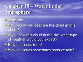
Fog: fog is a cloud that forms at or near the ground, but by processes different than those that create higher level clouds. • Advection (warm, moist air from sea blows onto cool land), Radiation (Earth’s surface and air near surface cools at night), Evaporation (air cooled by evaporation from water) and Upslope fog (when air cools as it rises along land surface). Fig. 19-13, p.457
Pressure and Wind • Warm air rises (low pressure region), cool air sinks (high pressure region). Wind is generated. Winds near the Earth’s surface always flow away from a region of high pressure and toward a low-pressure region, and are caused by pressure differences from unequal heatingofthe atmosphere. Fig. 19-14, p.458
Winds blow, as stated earlier, in response to differences in pressure. Fig. 19-16, p.459
Wind speed determined by magnitude of pressure differences over distance, called pressure gradient. • Points of equal pressure are connected by map lines called isobars. • Note in this pressure map steep pressure gradients in the NE and NW cause high winds that spiral CCW into the low pressure zones. Fig. 19-17, p.459
The Coriolis Effect deflects winds to the right in the NH (and to the left in the SH). Only winds blowing due east or west are unaffected. • Friction also plays a role, as wind speed generally increase with elevation. Fig. 19-18, p.460
Cyclones and Anticyclones. • A) in the NH, a cyclone consists of winds spiraling CCW into a low pressure region. • B) an anticyclone consists of winds spiraling CW out from a high-pressure zone. • What type of weather predominates these zones and why? Fig. 19-19, p.461
Fronts and Frontal Weather: • Air masses are classified by their source region. • Polar (P) am originate in the high latitudes and are cold; Tropical (T) am originate in the low latitudes and are warm; Continental (C) am originate over land (dry); Maritime (M) am originate over water and are moist. Fig. 19-20, p.462
Warm Fronts and Cold Fronts: a warm front forms when moving warm air collides with stationary (or slow moving) cold air; a cold front forms when moving cold air collides with stationary or slower moving warmer air. • Above are symbols commonly used in weather maps. Fig. 19-21, p.463
In a warm front, moving warm air rises gradually over cold air and cools adiabatically, generating clouds and usually light precipitation. Fig. 19-22, p.463
In a cold front, moving cold air slides abruptly beneath warm air, forcing it to rise steeply upwards; leading edge of a cold front is much steeper than a warm front, causing warm air to rise rapidly, creating a narrow band of violent weather. Fig. 19-23, p.463
An occluded front forms where warm air is trapped and lifted between two cold air masses. What happens here? Inclement weather from two fronts, generally short-lived (warm air mass cut off from moisture evaporating from Earth’s surface). • A stationary front is boundary between two stationary air masses. Can last for several days, similar to warm front weather (rain, drizzle, and fog may occur). Fig. 19-24, p.464
Middle-Latitude Cyclone… Fig. 19-25, p.465
A front develops… Fig. 19-25a, p.465
A small disturbance creates a kink in the front… Fig. 19-25b, p.465
A low pressure region and cyclonic circulation develop… Fig. 19-25c, p.465
An occluded front forms. Fig. 19-25d, p.465
Most North American cyclones follow certain paths called storm tracks from west to east (from jet stream and westerlies)… Fig. 19-26, p.466
Mountains, Oceans, Lakes and Weather • Mountain ranges and rain-shadow deserts. Fig. 19-27, p.466
Rain-shadow deserts lie east of the California mountain ranges. Rainfall is shown in cm/yr. Fig. 19-28, p.467
Sea and Land Breezes: a) sea breezes blow inland during the day. b) land breezes blow out to sea at night. • A monsoon is a seasonal wind and weather system caused by uneven heating and cooling of continents and oceans. More than half the inhabitants of the Earth depend on monsoons because the predictable heavy summer rains bring water to the fields of Africa and Asia. Fig. 19-29, p.467
Thunderstorms:a typical t-storm develops in three stages: 1) air rises, cools and condenses, creating a cumulus cloud; 2) latent heat of condensation energizes the storm, forming heavy rain and violent wind; 3) the cloud cools, convection weakens and the storm wanes. Fig. 19-30, p.468
Two hypothesis for the origin of lightning: 1) friction between intense winds and ice particles generates charge separation; 2) charged particles are produced from above by cosmic rays and below by interactions with the ground. The particles are then distributed by convection currents. Fig. 19-32, p.470