Download
1 / 15
150 likes | 164 Vues
This presentation discusses the importance of updating FEMA maps to reflect recent development and natural changes in flood hazard conditions. It also explores the requirements and impacts of the National Flood Insurance Program on projects in unnumbered "A" zones. Additionally, it covers the transition from Sea Level Datum of 1929 to the North American Vertical Datum of 1988 and the conversion between different datums using software tools like CORPSCON. The presentation concludes with an overview of potential NFIP program revisions and their side effects.

E N D
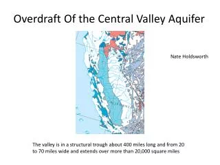
PRESENTATION TO THE CENTRAL VALLEY CHAPTER OF THE CALIFORNIA LAND SURVEYORS ASSOCIATION ON CURRENT ISSUES RELATED TO FLOOD CONTROL MATTERS IN THE CENTRAL VALLEY 2/22/12
FEMA MAP MODERNIZATION • (WHY MODERNIZE? 2005) • Flood hazard conditions are dynamic, and many NFIP maps may not reflect recent development and/or natural changes in the environment. • Updated NFIP maps can take advantage of revised data and improved technologies for identifying flood hazards. • Up-to-date maps support a flood insurance program that is more closely aligned with actual risk, encourage wise community-based floodplain management, and improve citizens’ flood hazard awareness. • Local communities and various stakeholders desired more timely updates of flood maps and easier access to the flood hazard data used to create the maps. • Map Modernization is a cornerstone for helping community officials and citizens be better prepared for flood-related disasters.
NATIONAL FLOOD INSURANCE PROGRAM REQUIREMENTS Project impacts in an unnumbered “A” Zone: • No Elevation Certificates because there is no established Base Flood Elevation (BFE) • Building Restrictions : Finished Floor must be constructed a minimum of 1 foot above the BFE • Requirement for detailed flood studies for any proposed development in excess of 5 acres, or has more than 50 lots. The project developer is required to have a detailed engineering study and topographic survey prepared to establish the Base Flood Elevation (BFE) and identify its boundaries on the project site per the National Flood Insurance Program Requirements.
SURVEY DATUMS Sea Level Datum of 1929: A vertical control datum established for vertical control in the United States by the general adjustment of 1929." The North American Vertical Datum of 1988 (NAVD 88) is the vertical control datum established in 1991 by the minimum-constraint adjustment of the Canadian-Mexican-U.S. leveling observations. It held fixed the height of the primary tidal bench mark, referenced to the new International Great Lakes Datum of 1985 local mean sea level height value, at Father Point/Rimouski, Quebec, Canada. Additional tidal bench mark elevations were not used due to the demonstrated variations in sea surface topography, i.e., the fact that mean sea level is not the same equipotential surface at all tidal bench marks Why did NGS change from NGVD 29 to NAVD 88? NAVD 88 was computed for many of the same reasons as NAD 83. About 625,000 km of leveling had been added to the NGVD since 1929. Thousands of bench marks had been subsequently destroyed and many others had been affected by crustal motion, postglacial rebound, and subsidence due to the withdrawal of underground fluids. Distortions amounting to as much as 9 meters had been seen due to forcing the new leveling to fit the NGVD 29 height values
CONVERSION BETWEEN DATUMS CORPSCON Coordinate Conversion Software (ERDC) US Army Corps of Engineers Research and Development Center: CORPSCON, Version 5.11, is an MS Windows based software program that allows the user to convert coordinates between Geographic, State Plane, and Universal Transverse Mercator (UTM) systems on the North American Datum of 1927 (NAD 27), the North American Datum of 1983 (NAD 83), and High Accuracy Reference Networks (HARNs). CORPSCON uses the National Geodetic Survey (NGS) program, NADCON, to convert between NAD 27, NAD 83, and HARNs. CORPSCON, Version 5.11, performs vertical conversions to and from the National Geodetic Vertical Datum of 1929 (NGVD 29) and the North American Vertical Datum of 1988 (NAVD 88). Vertical conversions are based on the NGS program VERTCON and can be performed for the continental United States only. CORPSCON, Version 5.11, will also calculate geoid-ellipsoid separations based on the NGS program Geoid96. Geoid-ellipsoid separations can be calculated for the Continental United States, Alaska, Hawaii, and Puerto Rico/U.S. Virgin Islands. VS. Field survey of local NGVD 29 and NAVD 88 monuments to determine a regional or site specific vertical datum shift.
NATIONAL FLOOD INSURANCE PROGRAM CHANGES • NFIP Reauthorization Guidance • On December 23, 2011, President Obama signed the Fiscal Year (FY) 2012 omnibus appropriations bill that includes a provision extending the NFIP through May 31, 2012 (Expired Sept 30, 2011). We will continue to keep you informed of the status of NFIP reauthorization. • Potential Program Revisions • (1) a meaningful long-term extension of the program; (2) movement toward risk-based premiums; (3) a reduction in price subsidies; (4) deductible increases that help increase program capacity while encouraging mitigation by consumers; (5) an increase in coverage limits that have not changed in more than 15 years; and (6) authorization for the purchase of additional living expense coverage (residential) or business interruption (commercial).
SIDE EFFECTS OF NFIP REAUTHORIZATION • Building restrictions are not specified in the legislation but would be triggered by revised maps and would remain in • place in perpetuity • The major incentive for building flood control improvements would be removed by requiring the protected areas to remain • on floodplain maps • Floodplain maps would cover such a large area, 80% of San Joaquin County, that potential economic development as • well as existing economic activity would relocate to other regions
DELTA STEWARDSHIP COUNCIL (DSC) • The DSC was formed in 2009 to develop the Delta Plan by 2012. • “Covered Actions” constitute any project that will occur in the Delta or Suisun Marsh, funded or approved by the State or a Local Public Agency or have significant effect on achieving flood control goals • Projects must be run by the DSC to ensure project consistency with the Delta Plan. • Control over Local Land Use Decisions.
ROLE OF SURVEYOR IN CALIFORNIA FLOOD CONTROL • Certified Elevation Certificates • Post processing of Lidar topographic regional data for flood mapping purposes . • Conversion of survey datums • Topographic mapping for regional flood studies • Coordination of flood hazard issues on land development projects