Download
1 / 22
220 likes | 239 Vues
GPS in Support of Biodiversity and Ecosystem Databases. by Greg Carlino, Ben Schmitz, and Erin Martin. Definitions. Biodiversity – “Earth’s rich variety of distinct species, the genetic variability within them, and the natural communities and ecosystems they inhabit.” (The Earth in Balance)

E N D
GPS in Support of Biodiversity and Ecosystem Databases by Greg Carlino, Ben Schmitz, and Erin Martin
Definitions • Biodiversity – “Earth’s rich variety of distinct species, the genetic variability within them, and the natural communities and ecosystems they inhabit.” (The Earth in Balance) • Ecosystem – “A community of plants and animals together with the physical environment they inhabit.” (American Heritage Dictionary)
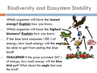
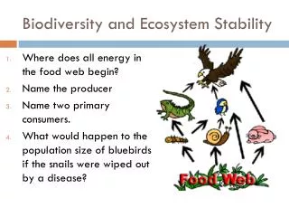
Importance of Biodiversity • Leads to a sustainable environment • Less susceptible to disease, drought, etc. • Economic value of diversity • Culture and identity • Widely researched topic
GPS and Environmental Databases • Speed • Large datasets • Variable accuracy • Compatible with remote sensing, GIS, and traditional surveying • Economic method of data collection
Biodiversity in BrazilNature Conservancy Study • Needs info about flora (plants) and fauna (animals), and their habitats in order to prioritize conservation efforts. • Often needs to make informed decisions quickly • Use REA coarse/fine filter approach (6 mo.) • Remote Sensing (initial classification) • Field Observations (verify classifications) • Overflights (verify areas inaccessible by foot)
Results • Assumption that drier highland areas were located outside the existing park was proven correct • Total of 148,200 acres of land identified as prime conservation areas and acquired
Gone Fishing in the Pacific Northwest • GPS Used to Map Chinook Salmon Spawning Habitat • Salmon part of identity, culture, religion, and economic system of people • Series of hydroelectric dams built on Snake River • Salmon listed as endangered • Corps required to do a study
PNNL Study • Search for redds (salmon nests) • One month window • Used GPS, GIS, Underwater Video • Method • GIS query to find likely locations • Transects set up • Boat location tracked with 12-channel, L1, C/A –code Trimble Pro XR GPS receiver • Underwater camera • Onboard PC for real-time visualization
Redd Spottings… • Shore-based surveyor with laser transit and prism on boat • Also depthfinder, current profiler, camera • Rebar with survey tape used to mark • DGPS later used • Submeter accuracy obtained on a moving boat on a reference-free river with high canyon walls
Results • Redds mapped at around 1m accuracy • Corps could plan construction projects and dam operations that would minimize effect on Chinook Salmon • Technique has been applied elsewhere
Saving an Endangered Species GPS Used to Monitor and Manage Wild Horse and Burro Herds in West • Symbols of the West • By mid 19th Century, 2 million horses roamed North America • Inhumane capture and destruction for commercial purposes reduced numbers to 17,000 by 1971 • Congress passes Wild Free-Roaming Horse and Burro Act (1971)
Resource Management • Jurisdiction of Bureau of Land Management (div. of Dpt. of Interior) • Collecting base information 80% of total cost (gather, analyze, display) • Tracking Horses • Use GPS in conjunction with PC to provide automated field data collection system • Supplies needed reference framework (grounding) for GIS mapping and analysis
Why GPS ? • BLM’s findings are often challenged • Need to display current and past flight paths and other supporting data • System must be accurate to 40 meters • System must be capable of recording data in a downloadable format for use in subsequent Land Information Systems
Using GPS to Research Animal Species • 1995 study of Southern Elephant Seals in Falkland Islands • Goal to reach conclusion about individual variation and evolution of social behavior • Why use mapping to study seals? • Space related phenomenon • Territorial defense • Tracking of “tagged” individuals provides huge amounts of data (activity, movement) • Study of long-distance migratory species
GPS in Use • Mapping perimeter of harems • Tracking of Alpha-males and primary breeding females • Data used to tabulate census numbers and population density
Advantages of GPS • Operates under any weather conditions • Harsh Falkland Island climate • Poor land mobility of seals means that spatial relationships must be defined over short distances • Sub meter accuracy required • Ease and speed of use • Data format easily transformed
National Institute of Water and Atmospheric Research (NIWA) • Another agency that has implemented GPS into many research projects involving marine taxonomy – biodiversity inventory • 40 years of oceanographic sampling in New Zealand, Australia, Pacific Islands, and Antarctica • 1992 Convention on Biological Diversity ruled that member nations must inventory habitats and species for sustainable resource management – GPS helped NIWA accomplish this goal. • Underwater cameras aided by satellite navigation system to create a biodiversity research library http://katipo.niwa.cri.nz/taxonomy/
Save the Elephant Organization • Charity founded in 1993 by Dr. Ian Douglas-Hamilton who made a pioneering study of elephant behavior • Used GPS collars to study long distance movements of herds • Needed to determine how elephants make decisions concerning where to roam in order to predict ecological changes on elephants and the biodiversity of the area
Elephant Migration Map • Map created by collecting and plotting GPS co-ordinates of Stratus (family matriarch) • Proved long standing theory that elephants were traveling from Samburu all the way to Il Ngwesi • www.savetheelephants.org
Forest Fragment Project • Manaus, Brazil • Objective to map biomass changes in central Amazonia • Relate field data with remote sensing data from Landsat TM images
GPS and Environmental Databases • Speed • Large datasets • Variable accuracy • Compatible with remote sensing, GIS, and traditional surveying • Economic method of data collection
References • The Earth in Balance, Maintaining Brazil’s Biodiversity, GPS World, June 1996. • Track ‘em Cowboy! GPS Rides the Range, GPS World, September 1995. • Reed Recon: Mapping Chinook Spawning Habitat, GPS World, January 1999. • A Very Spatial Relationship, GPS Mapping Aids Understanding of Elephant Seal Behavior, GPS World, July 1999. • The American Heritage Dictionary, 2nd Edition, Houghton Mifflin Company, Boston, 1985.