Download
1 / 40
400 likes | 603 Vues
The Global Positioning System: Policy, Program Status and International Activities . 15 th Korean Global Navigation Satellite System (GNSS) Workshop Busan, Republic of Korea October 30-31, 2008. Ray E. Clore Senior Advisor for GPS-Galileo Issues Office of Space and Advanced Technology

E N D
The Global Positioning System: Policy, Program Status and International Activities 15th Korean Global Navigation Satellite System (GNSS) Workshop Busan, Republic of Korea October 30-31, 2008 Ray E. Clore Senior Advisor for GPS-Galileo Issues Office of Space and Advanced Technology U.S. Department of State
Overview • U.S. Space -Based Positioning, Navigation and Timing (PNT) Policy • GPS Program Status and Modernization • GPS Augmentations Status • U.S. International Activities
Provide GPS and augmentations free of direct user fees on a continuous, worldwide basis Provide open, free access to information needed to develop equipment Improve performance of GPS and augmentations to meet or exceed that of international systems Encourage international development of PNT systems based on GPS Seek to ensure international systems are interoperable with civil GPS and augmentations Address mutual security concerns with international providers to prevent hostile use 2004 U.S. Space-Based PNT Policy
2004 U.S. Space-Based PNT Policy • Recognizes the changing international scene • Other nations are implementing space-based systems that provide PNT services • National Executive Committee (EXCOM) for Space-Based PNT • Chaired by Deputy Secretaries of Defense and Transportation • Membership includes: State, Interior, Agriculture, Commerce, Homeland Security, Joint Chiefs of Staff and NASA • National Coordination Office (NCO) • Established with staff from member agencies • National Space-Based PNT Advisory Board
Overview • U.S. Space -Based Positioning, Navigation and Timing (PNT) Policy • GPS Program Status and Modernization • GPS Augmentations Status • U.S. International Activities
Current Constellation 29 Operational Satellites (Nominal Constellation: 24) • 11 Block IIA satellites operational • 12 Block IIR satellites operational • 6 Block IIR-M satellites operational • Transmitting new second civil signal (L2C) • 2 Block IIR-M satellites remain to be launched • Continuously assessing constellation health to determine launch need • Next IIR-M launch planned for early 2009 • First IIF projected for launch mid 2009 • Global GPS civil service performance commitment met continuously since 1993
Current GPS Accuracy • Signal-In-Space (SIS) User Range Error (URE): 0.92 m RMS • User Position Error (maximum): 4 – 8 meters • User Position Error (observed): 2 – 4 meters Signal-in-Space User Range Error (SIS URE) the difference between a GPS satellite’s navigation data (position and clock) and the truth, projected on the line-of-sight to the user
GPS Modernization • System-wide improvements in: • Accuracy • Availability • Integrity • Reliability • Backward compatibility • Robustness against interference • Improved indoor, mobile, and urban use • Interoperability with other space-based PNT systems
Modernized GPS – Civil Signals • Second civil signal (“L2C”) starts with GPS Block IIR-M • Designed to meet commercial needs • Higher accuracy through ionospheric correction • Higher effective power and improved data structure reduce interference • Speed up signal acquisition and enable miniaturization of receivers • First Launch Sep 2006; expect 24 satellites: ~2016 • Third civil signal (“L5”) starts with GPS Block IIF • Designed to meet requirements for transportation safety-of-life (aviation) • Highly protected Aeronautical Radio Navigation Service (ARNS) band • First launch: ~2009; 24 satellites: ~2018 • Fourth civil signal (“L1C”) starts with GPS Block III • Designed with international partners to enable GNSS interoperability • First launch: ~2014; 24 satellites: ~2021
Recent GPS Program Accomplishments • Completed GPS Architecture Evolution Plan (AEP) • Transitioned to new GPS Ground Control Segment – Sept. 2007 • Activated fully capable backup GPS Operations Center at VAFB, CA • Announced GPS III without Selective Availability – Sept 2007 • Awarded GPS OCX Development Contracts -Nov 2007 • ICAO accepted updated U.S. offer on GPS/SPS and WAAS • Launched two GPS-IIR(M) satellites (Dec 07/Mar 08) • Awarded GPS IIIA Contract - May 2008
Overview • U.S. Space -Based Positioning, Navigation and Timing (PNT) Policy • GPS Program Status and Modernization • GPS Augmentations Status • U.S. International Activities
WAAS Architecture 38 Reference Stations 3 Master Stations 4 Ground Earth Stations 2 Geostationary Satellite Links 2 Operational Control Centers
PanAmSat 133°W Telesat 107°W Geostationary Satellites (GEO)
WAAS Avionics Status • General Aviation • Over 37,000 Units Sold • Increasing at ~1000 Units Per Month • New Products Coming to Market in Late 2008 • Business & Regional Aircraft • Over 500 Units Sold Since 2007 • Two Additional Products Coming to Market in Late 2008 • Cessna CJs Delivering with WAAS Avionics in 2009 • Acceptance Rates Should Increase Significantly in 2009 • Air Carrier & Cargo Aircraft • Southwest Airlines Equipping 200 Boeing 737s • Federal Express Has Equipped 253 Caravan Aircraft • Horizon Airlines Equipping 48 Bombardier Aircraft • Helicopter Aircraft Implementing WAAS • Significant Growth Projected for First Responders • WAAS Avionics are Interoperable with Other SBASs
WAAS Approach Procedures - Projected to Exceed Legacy Systems, eg. ILS By Sep 2008 - September 2008 • 1,333 WAAS LPV Approach Procedures • 783 at non-ILS runways • 329 at non-ILS airports WAAS Procedures to be Published to All Instrument Runways in the NAS by 2018
Future WAAS Considerations • GNSS Modernization • GPS Dual Frequency (L1/L5) Service Provides Foundation • Potential for Larger GNSS or Use of Multiple GNSS Constellations • User Equipment Standards Development for New Signals • WAAS Dual Frequency Upgrade • Determine Appropriate Level of Dual Frequency Integration Required to Maximize Benefit With Minimum Impact • Established GNSS Evolutionary Architecture Study (GEAS) to Investigate Long Range Planning for Dual Frequency GPS • Develop Architectural Alternatives to Provide Worldwide LPV-200 Service in the ~2020-2030 Timeframe • Leverage Lessons Learned on WAAS/LAAS to Identify the Best Architecture Alternative to Meet Aviation Integrity Requirements
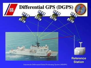
National Differential GPS • Operated/managed by USCG/NAVCEN as a joint system with Maritime DGPS • Extension of Maritime DGPS • Corrections broadcast at 285 and 325 kHz using Minimum shift Keying (MSK) modulation • Real-time differential GPS corrections provided in Radio Technical Commission for Maritime Services (RTCM) SC-104 format • No data encryption • Real-time differential corrections for terrestrial mobile and static applications • Single coverage on the ground over 92% of CONUS; double coverage over 65% of CONUS
National Differential GPS (2) • Accuracy: < 1 meter at broadcast site • Degrades at an approximate rate of 1 meter for each 150 km distance from site • Typical user equipment achieves 1-2 meter horizontal accuracies throughout the coverage area, in real time • High-end user equipment achieves accuracies better than 1 meter, real time • Availability: 99%+ • Integrity: alarm within 6 seconds; site monitors • Fix rate: 1-20 per second, three dimensional
NDGPS Highway Applications • Surveys: Land, roads, hydrological and environmental location, and management and maintenance • Inventory and asset management: Infrastructure asset location, assessment, management, maintenance and protection • Utilities: Location, management, and maintenance • Roadside management: Precision application of pesticides, runoff minimization, avoidance of protected species, roadside features (condition and location) • Law Enforcement: Incident location and reporting, emergency response
NDGPS Applications • U.S. Army Corps of Engineers requires two meter accuracy to position dredges
NDGPS Monitoring of Space Weather • NOAA’s Space Weather Prediction Center uses M/NDGPS data to map the spatial distribution of free electrons in the ionosphere, once every 15 minutes • and delays the arrival of GS The distribution of free electrons in the ionosphere affects HF radio communication and delays the arrival of GPS signals that is interpreted as position errors, which can be as large as 100 meters in extreme cases.trge as 100 meters in extreme cases
Managed by NOAA 1,200+ sites 200+ public, private, academic organizations Provides highly accurate, 3-D positioning Centimeter-level precision Tied to National Spatial Reference System Uses include land management, coastal monitoring, civil engineering, boundary determination, mapping, geographical information systems, geophysical and infrastructure monitoring, and future improvements to weather prediction and climate monitoring National Continuously Operating Reference Stations (CORS)
Overview • U.S. Space -Based Positioning, Navigation and Timing (PNT) Policy • GPS Program Status and Modernization • GPS Augmentations Status • U.S. International Activities
2004 U.S. Space-Based PNT Policy(Excerpts focused on International Relations) Goals: • U.S. space-based PNT systems and services remain essential components of internationally accepted PNT services • Promote U.S. technological leadership in applications involving space-based PNT services To achieve this, the United States Government shall: • Encourage foreign development of PNT services/systems based on GPS • Seek to ensure foreign space-based PNT systems are interoperable with civil GPS and augmentations • At a minimum, ensure compatibility The Secretary of State shall: • Promote the use of civil aspects of GPS and its augmentation services and standards with foreign governments and other international organizations • Lead negotiations with foreign governments and international organizations regarding civil PNT matters
Satellite-Based Augmentations WAAS (3) MSAS (2) EGNOS (3) GAGAN (3) SDCM (2?) Planned GNSS • Global Constellations • GPS (24+) • GLONASS (24) • Galileo (27) • Compass (35) • Regional Constellations • QZSS (3) • IRNSS (7)
U.S. Objectives in Working with Other GNSS Service Providers • Ensure compatibility ― ability of U.S. and non-U.S. space-based PNT services to be used separately or together without interfering with each individual service or signal • Radio frequency compatibility • Spectral separation between M-code and other signals • Achieve interoperability – ability of civil U.S. and non-U.S. space-based PNT services to be used together to provide the user better capabilities than would be achieved by relying solely on one service or signal • Primary focus on the common L1C and L5 signals • Ensure a level playing field in the global marketplace Pursue through Bi-lateral and Multi-lateral Cooperation
IRNSS GALILEO COMPASS QZSS GPS GLONASS The Goal of RNSS Civil Interoperability • Ideal interoperability allows navigation with one signal each from four or more systems with no additional receiver cost or complexity Interoperable = Better Together than Separate
U.S. - Europe Cooperation • U.S.-EU agreement signed in 2004 provides solid foundation for cooperation • Four working groups were set up under the agreement: • Technical, trade, and security issues working groups have met • Improved new civil signal (MBOC) adopted in July 2007 • First Plenary Meeting in October 2008 June 26, 2004, press conference at U.S.-EU Summit in Ireland (U.S. Sec. of State Colin Powell, Irish Foreign Minister Brian Cowen, EU Vice-President Loyola De Palacio)
U.S. - Russian Federation Cooperation • U.S.- Russia Joint Statement issued in December 2004 • Negotiations for a U.S.-Russia Agreement on satellite navigation cooperation have been underway since late 2005 • Several very productive technical working group meetings have been held: • Russia WG-1 chair proposed adopting two new civil CDMA signals at L1, L5 to be interoperable with GPS • Still under discussion within the Russian Government • Next WG-1 meeting is planned for December 2008
U.S. - Japan Cooperation • Japan’s status as a world leader in GPS applications and user equipment makes it an important partner • Regular policy consultations and technical meetings on GPS cooperation began in 1996 and led to the 1998 Clinton-Obuchi Joint Statement • Both countries have benefited from the close relationship: • QZSS is designed to be compatible and interoperable with GPS • U.S. working with Japan to set up QZSS monitoring stations in Hawaii and Guam • Next plenary meeting is planned in Nov. 2008
U.S. - India Cooperation • Policy and technical consultations on GPS cooperation underway since 2005 • One aim is to ensure interoperability between GPS augmentation system WAAS and India’s planned GAGAN augmentation system based on GPS • Another important topic is ionospheric distortion and solutions • U.S.-India Joint Statement on GNSS Cooperation issued in February 2007 in Washington • Bi-lateral meeting held in Bangalore in September 2007 • Technical Meeting focused on GPS-IRNSS compatibility and interoperability held in January and July 2008
Asia-Pacific Economic Cooperation GNSS Implementation Team (GIT) • Promote implementation of regional GNSS augmentation systems to enhance inter-modal transportation and recommend actions to be considered in the Asia Pacific Region • Reports to Transportation Working Group (TPT-WG) through the Inter-modal Experts Group (IEG)
APEC GNSS recent activities • Thailand with the support of AEROTHAI hosted a GNSS Technological Innovation Summit in May 2008 • Completed the successful $1 million GNSS test bed project, located in Bangkok and funded by the U.S. Trade and Development Administration and supported by the U.S. FAA • Updated the Terms of Reference to take account of environmental benefits • Achieved consensus on a project proposal to survey and assess current applications for surface transportation utilizing GNSS • Adopted a Program of Action
APEC TPT-WG Outcome • The GNSS Implementation Team (GIT) reported to the Inter-modal Experts Group (IEG). • The IEG was impressed with the GNSS Technological Innovation Summit and the GIT 12 Outcomes and forwarded project proposal to APEC. • GIT contributed to the deliberations in all four working groups (Inter-modal, Maritime Safety, Maritime Experts and Aviation). • Interest expressed in learning more about GNSS in the Plenary and in the maritime safety group at the next APEC Transportation Working Group.
International Committee on Global Navigation Satellite Systems (ICG) • Emerged from 3rd UN Conference on the Exploration and Peaceful Uses of Outer Space July 1999 • Promote the use of GNSS and its integration into infrastructures, particularly in developing countries • Encourage compatibility and interoperability among global and regional systems • Members include: • GNSS providers (U.S., EU, Russia, China, India, Japan) • Other Member States of the United Nations • International organizations/associations
International Committee on Global Navigation Satellite Systems (ICG) • ICG-2 held in September, 2007 in India • Established Providers Forum to address common issues • Began implementation of the ICG Work Plan within established working groups: • A. Interoperability and compatibility • B. Enhancement of performance of GNSS services • C. Information dissemination, education, outreach & coordination • D. Interaction with monitoring & reference station network organizations • U.S. will host the 3rd ICG in December 2008 • http://www.geolinks.org/ICG3/
ICG Providers Forum • Six space segment providers listed previously are members • Purpose: • Focused discussions on compatibility and interoperability, encouraging development of complimentary systems • Exchange of detailed information on systems and service provision plans • Exchange views on ICG work plan and activities • Consensus reached at the first meeting on general definitions for compatibility and interoperability • Including spectral separation between each system’s authorized service signals and other systems’ signals http://www.unoosa.org/oosa/en/SAP/gnss/icg.html
Summary • As new space-based GNSS are emerging globally, interoperability is the key to “success for all” • U.S. is actively engaged in bi-lateral, regional, and multi-lateral cooperation on space-based navigation issues • International cooperation in the context of National Space-Based PNT Policy principles is a top priority for the U.S. Government
Contact Information Ray E. Clore Senior Advisor for GPS-Galileo issues Office of Space and Advanced Technology U.S. Department of State 1990 K Street NW, Suite 410 Washington, D.C. 20006 202-663-2394 (office) clorere@state.gov http://www.state.gov/g/oes/sat/