Innovations in Topographic Mapping: Insights from the 8th ICA Mountain Cartography Workshop
The 8th ICA Mountain Cartography Workshop held in Taurewa, New Zealand from September 1-5, 2012 focused on the evolution of topographic map design. Participants explored principles of continuous features, graphic definition, and the effective use of color and symbols. Key discussions included challenges of relief shading, balancing map elements, and advancements in printing technology. The workshop emphasized the importance of clear and legible map images while integrating contemporary design techniques, showcasing the future of topographic mapping in mountainous regions.

Innovations in Topographic Mapping: Insights from the 8th ICA Mountain Cartography Workshop
E N D
Presentation Transcript
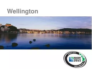
ICA - Mountain Cartography Workshop, Taurewa, New Zealand New topographic mapping New topographic mapping Wellington Walks ICA - Mountain Cartography Workshop, Taurewa, New Zealand 1-5 September 2012 An exercise in topographic map evolution 8th ICA Mountain Cartography Workshop, Taurewa, New Zealand 1-5 Sept 2012 1
Principles? Continuous features – continuous symbols Accurately defined features – clear graphic definition Relief: subtle, integrating minimum colour influence Avoid contrasting lineal elements Careful use of black colour Re-evaluate traditional symbols Simplify symbol families New topographic mapping ICA - Mountain Cartography Workshop, Taurewa, New Zealand 2
Cliff or river terrace Waterfall New topographic mapping ICA - Mountain Cartography Workshop, Taurewa, New Zealand 3
Cliff or river terrace Waterfall New topographic mapping ICA - Mountain Cartography Workshop, Taurewa, New Zealand 4
Hot spring Swamp Pine forest New topographic mapping ICA - Mountain Cartography Workshop, Taurewa, New Zealand 5
Hot spring Swamp Pine forest New topographic mapping ICA - Mountain Cartography Workshop, Taurewa, New Zealand 6
Relief shading a vital visual component balance with other components essential specially produced by Geographx 20m pixel: typically… flat areas 10C, 7Y, 7M, 0K deep shadow 40C, 30M, 25Y, 4K result is a clear legible image ICA - Mountain Cartography Workshop, Taurewa, New Zealand 7
Black relief difficulties: Difficult balance between relief and text Conflict with area tints, lines and text Gloomy or muddy appearance of mapCMY no K relief advantages: Managed balance between relief and text Managed discrimination between elements Clean map image with increased legibility ICA - Mountain Cartography Workshop, Taurewa, New Zealand 9
Offset printing ‘printing’ is not just printingnewtechnology is amazing design to the machine capabilities printer uses Heidelberg and HP IndigoPaper ‘paper’ is not just paperuseful to know the paper’s characteristics two-sided surface differences 94gsm high-wet-strength and 113gsm Sumo ICA - Mountain Cartography Workshop, Taurewa, New Zealand 10
ICA - Mountain Cartography Workshop, Taurewa, New Zealand 11
ICA - Mountain Cartography Workshop, Taurewa, New Zealand 12
Thanks for your attention and the discussion 14