Download
1 / 21
220 likes | 518 Vues
Project Coordination Activities. Meeting with Cape Cod National Seashore – August 27 Cape Cod Commission USDA Meeting – September 16. Nauset Regional High School. Drill Site. Drill Site at NRHS. Mud System. Drill Cuttings - Aquifer Zone. Well Screen. Well Development.

E N D
Project Coordination Activities • Meeting with Cape Cod National Seashore – August 27 • Cape Cod Commission • USDA Meeting – September 16
Nauset Regional High School Drill Site
Nauset High SchoolHydrogeologic Conditions Deep boring installed to 400’ Water table at 50’ Good material to 105’ Silts and clays below Installed well at 90’
District H Hydrogeologic Conditions Summary • Deep boring: 405’ bgs • DTW – 30’ bgs • Potentially productive zones: Shallow 106-116’ bgs Intermediate 207-217’ bgs • Freshwater/Saltwater Interface 343 feet
District HWell Installations Deep well: 346’ Intermediate well: 207’ Shallow well: 116’
District H Well Development
District H Well Development
District H Drill Log • Potentially productive aquifer zone (sand) 80-218’ • Fresh Water/Salt water interface: 143’ bgs • Specific Capacity Shallow: 33 gpm/ft Intermediate: 5-10+ gpm/ft • Water quality: Shallow – excellentIntermediate – Waiting on data Fresh Water Salt Water Sand Silt and Clay
District H Hydrogeologic Issues • Response of salt water transition zone with pumping • Proximity of vernal pools • Groundwater/vernal pool interaction
District H Deep Test Well Tidal influences on water level in deep test well
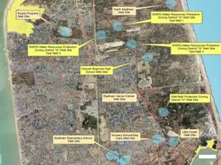
Single Family Residential > 80,000 sq. ft. Single Family Residential 40,000-79,999 sq. ft. General Business Conservation/ Passive Recreation General Industrial Vernal Pools
District G Drill Site • Drill site and 400’ buffer entirely within Town-owned land • Currently installing deep boring • Site has available land for more than one test site