Download
1 / 18
180 likes | 336 Vues
Alternative Approaches to Campsite & Trail Monitoring. Jeff Marion, Unit Leader/Scientist Virginia Tech Field Unit, USGS, Patuxent WRC jmarion@vt.edu, 540-231-6603. Monitoring Approaches. Photographic Systems - Aerial photography, photographs from permanent photopoints, stereo photographs.

E N D
Alternative Approaches to Campsite & Trail Monitoring Jeff Marion, Unit Leader/Scientist Virginia Tech Field Unit, USGS, Patuxent WRC jmarion@vt.edu, 540-231-6603
Monitoring Approaches Photographic Systems- Aerial photography, photographs from permanent photopoints, stereo photographs. Condition Class Systems- Descriptive statements that characterize a range of site degradation from low to high. Rating Systems- Separate assessments of multiple indicators with categorical ratings. Measurement Systems- Separate assessments of multiple indicators with measurements
Evaluation and Selection Criteria Measurement Scale- Ordinal or ratio measures? Accuracy vs. Precision- Accuracy refers to how close measures are to the true value. Precision refers to how close repeated measures of an attribute are to each other and to the sensitivity of the measurement method. Measurement error can arise from the poor application of methods or from coarse assessment methods. Sensitivity- How large must a change be for it to be identified confidently as a real change in resource conditions?
1985 1988 Photographic Systems Aerial photography, photographs from permanent photopoints, stereo photographs.
Photographic Systems Advantages- Rapid, provides photographs for direct visual comparisons. Disadvantages- Variable photographic quality, can’t cover all areas of a site, difficult to obtain accurate quantitative data, aerial photos useful only when tree cover is absent.
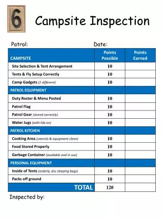
Ratings:Condition Class Class 1: Campsite barely distinguishable; slight loss of vegetation cover and/or minimal disturbance of organic litter. Class 2: Campsite obvious; vegetation cover lost and/or organic litter pulverized in primary use areas. Class 3: Vegetation cover lost and/or organic litter pulverized on much of the site; some soil exposed in primary use areas. Class 4: Nearly complete or total loss of vegetation cover and organic litter; bare soil widespread. Class 5: Soil erosion obvious, as indicated by exposed tree roots and rocks and/or gullying.
Condition Class System Advantages - Rapid and easy to apply, provides a useful summary of general site conditions. Disadvantages - Ordinal data limits summary and analysis capabilities, no information on the condition of individual indicators, low accuracy. Assessment Time - About 2 minutes for one staff.
Rating Systems Process- Separate assessments of multiple indicators with categorical ratings. Example- Site size is roughly measured or estimated to select an appropriate category: 1) < 500 ft2 2) 501 - 1000 ft2 3) > 1000 ft2
Rating Systems Advantages - Fairly rapid and easily applied, provides information on a variety of indicators. Disadvantages - Yields ordinal data, low accuracy due to rapid assessments and use of categories. Assessment Time - About 10 minutes for one staff.
Measurement Systems Process- Separate assessments of multiple indicators with measurements or counts. Example- Site size is measured using one of the following methods: Geometric Figure Method, Fixed Radial Transect Method, or Variable Radial Transect Method.
Variable Radial Transect Method 75, 5.0 143, 7.3 153, 9.3 31, 7.0 53, 4.2 141, 1.9 168, 9.9 10, 7.8 178, 5.7 345, 7.8 193, 11.2 326, 4.2 333, 4.2 248, 4.2 204, 10.8 207, 8.7 291, 4.4
Site Boundaries Identified by pronounced changes in vegetation, organic litter, or topography
Measurement Systems Advantages - Provides more accurate ratio level information on a variety of indicators, minimizes measurement error. Disadvantages - More time-consuming, particularly during reassessments. Assessment Time - About 15 - 25 minutes for two staff.
Problem Assessment Point Sampling Trail Assessment Survey Types
I3 I1 I2 I4 I5 I6 T6 T4 T1 T2 T3 T5 Common Trail Indicators Soil Erosion • Cross Sectional Area (sq ft) PS • Maximum Incision (in) PS • Excessive Erosion (# ft/mi, lineal ft, % of trail length) PA PA - Problem Assessment, PS - Point Sampling
Common Trail Indicators Tread Muddiness • Muddiness (% of tread width) PS • Excessive Muddiness (# ft/mi, lineal ft, % of trail length) PA Tread Width • Tread Width (ft) PS • Excessive Width (# ft/mi, lineal ft, % of trail length) PA PA - Problem Assessment, PS - Point Sampling
Common Trail Indicators Multiple Treads • Multiple Treads (# at sample points) PS • Multiple Treads (# ft/mi, lineal ft, %) PA Visitor-Created Trails • Informal Trails (#, #/mi, lineal extent, % of formal trail miles) • Other concerns related to informal trails: density, proximity to sensitive resources, and condition PA - Problem Assessment, PS - Point Sampling