Summary
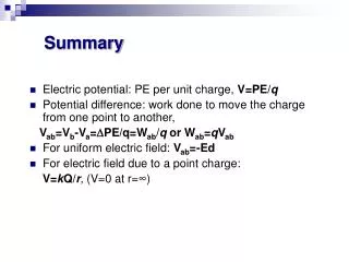
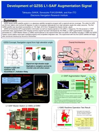
Message Generator. Ionosphere Processor. I/F. Storage. Storage. Storage. System. Horizontal Error. Vertical Error. GPS Only. RMS. 1.45 m. 2.92 m. Max. 6.02 m. 8.45 m. GPS only. With L1-SAIF. Router to GEONET. Augmented by L1-SAIF. RMS. 0.29 m. 0.39 m. GEONET Server.

Summary
E N D
Presentation Transcript
Message Generator Ionosphere Processor I/F Storage Storage Storage System Horizontal Error Vertical Error GPS Only RMS 1.45 m 2.92 m Max 6.02 m 8.45 m GPS only With L1-SAIF Router to GEONET Augmented by L1-SAIF RMS 0.29 m 0.39 m GEONET Server UPS Max 1.56 m 2.57 m UPS Development of QZSS L1-SAIF Augmentation Signal Takeyasu SAKAI, Sonosuke FUKUSHIMA, and Ken ITO Electronic Navigation Research Institute Summary QZSS (quasi-zenith satellite system) is a Japanese satellite navigation program with a regional service coverage. The orbits for QZS are 24-hour elliptic orbit inclined 45 degrees in order to broadcast radiosignals from high elevation angle into urban canyons. The first QZSS satellite was launched successfully on 11th Sept. 2010 from Tanegashima Space Center, Japan. QZSS will broadcast GPS augmentation information as well as ranging signals on the GPS L1 frequency. For this purpose L1-SAIF (submeter-class augmentation with integrity function) signal has been developed by the ENRI. L1-SAIF augmentation messages are generated at L1-SAIF Master Station (L1SMS) and broadcast to the experimental area via QZSS. All facilities including L1SMS and QZSS master control station have been installed properly and completed integration test. The experiment with the first QZSS satellite will begin after functional checkout by the end of November. QZSS Concept: Navigation signal from high elevation angle Overall Architecture Navigation Signals L1: 1575.42 MHz L2: 1227.60 MHz L5: 1176.45 MHz LEX: 1278.75 MHz GPS Satellites GPS/GEO QZS QZS Satellite TWSTFT Up: 4.43453GHz Down: 12.30669GHz Satellite Laser Ranging TT&C / NAV Message Uplink TT&C / NAV Msg Uplink Station Time Mgmt Station Monitor Station NW SLR Site User Receiver • Signal from high elevation angle • Applicable to navigation services for mountain area and urban canyon Master Control Station (MCS) GEONET (GSI) • Footprint of QZS orbit • Centered 137E • Eccentricity 0.1, Inclination 45deg Function distributed in each institute Timing management by NICT, WADGPS service by ENRI, etc. (Courtesy: JAXA QZSS PT) TWSTFT: Two Way Satellite Time and Frequency Transfer QZS-1 Satellite “Michibiki” L1-SAIF Augmentation Signal L1-SAIF Ranging QZS satellite GPS Satellites L1-SAIF Correction Ranging Signal 25.3m L1-SAIF Integrity Radiation Cooled TWT TWSTFT Antenna • L1-SAIF (Submeter-class Augmentation with Integrity Function) augmentation signal provides: • (1) Differential Correction information improving position accuracy; Target accuracy = 1 m; • (2) Integrity information for ensuring reliability of position information; • (3) An additional ranging source to improve availability of satellite constellation. • User receiver do not need additional antenna and/or RF circuit to receive L1-SAIF signal due to its compatibility with the GPS signal; • ENRI has been involved the program and developing L1-SAIF. C-band TTC Antenna Laser Reflector User Receivers (c) 三菱重工業 L-band Helical Array Antenna L1-SAIF Antenna • Successfully Launched at 20:17 of Sept. 11, 2010 from Tanegashima Space Center; • Now initial checkout in progress; First navigation signals successfully broadcast since Oct. 19. L1-SAIF Master Station (L1SMS) at ENRI L1SMS Realtime Operation Test Result • User position error measured at GEONET site 40058 (Takayama at the center of Mainland of Japan); • Period: Jan. 19 to 23, 2008 (5 days). NOTE: This result is obtained by the survey grade antenna and receiver.