Download

1 / 21
230 likes | 259 Vues
Learn about Earth measurement, geodesy, and geosciences using GNSS. Global impacts, climate change modeling, and space storm predictions explored.

E N D
NASA GNSS Applications & Geosciences Ruth E. Neilan Jet Propulsion Laboratory California Institute of Technology International GNSS Central Bureau Pasadena, CA Munich GNSS SummitMarch 8, 2007
Overview • Early NASA role in GPS - historical perspective • GNSS for Geodesy and Geosciences • International GNSS Service (IGS) • Some photos of IGS stations • AFREF - Unification of African Reference Frames • Global Geodetic Observing System (GGOS) • Contact Info
Rear Admiral John D. Bossler, &Charles.W. Chalstrom “GPS Instrumentation and Federal Policy”, Proceedings, First International Symposium on Precise Positioning with the Global Positioning System, Vol. 1, Rockville, MD, May 1985
GPS Policy Affects Civil Use - 1980 PNT Policy Today: Space Based Position Navigation and Timing, December 2004
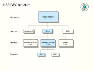
Geodesy: Measurement Of the Earth and its Potential Fields
SOLID EARTH OCEANS IONOSPHERE ATMOSPHERE Earth rotation Polar motion High resolution 3D ionospheric imaging Climate change & weather modeling Shape and defor- mation of Earth Significant wave height Global profiles of atmos density, pressure, temp, and geopotential height Ionospheric struc- ture & dynamics Location & motion of the geocenter Ocean geoid and global circulation Iono/thermo/atmo- spheric interactions Structure, evolution of the tropopause Gross mass distribution Short-term eddy scale circulation Onset, evolution & prediction of Space storms Atmospheric winds, waves & turbulence Structure, evolution of the deep interior Surface winds and sea state Tropospheric water vapor distribution TIDs and global energy transport Precise global reference frame Structure & evolution of surface/atmosphere boundary layer Precise ion cal for OD, SAR, altimetry Geoscience thru GNSS SOLID EARTH OCEANS IONOSPHERE ATMOSPHERE
International GNSS Service Formerly theInternational GPS Service The IGS is a voluntary federation of more than 200 worldwide agencies in more than 80 countries that pool resources and permanent GPS station data to generate precise GPS products. Many earth science missions and measurements, and multidisciplinary applications, rely upon the openly-available IGS products such as ephemerides and coordinate time series. Over 350 permanent tracking stations operated by more than 100 worldwide agencies comprise the IGS network. Currently the IGS supports two GNSS: GPS and the Russian GLONASS. GPS Applications in IGS Projects & Working Groups IGS products are formed by combining independent results from each of several Analysis Centers. Improvements in signals and computations have brought the centers’ consistency in the Final GPS satellite orbit calculation to ~ 2cm. Atmosphere WG Sea Level - TIGA Project Real-Time WG Data Center WG GNSS WG IGS Reference Frame Timing and Precise Clocks GLONASS Pilot Service Project Ionosphere WG Graph courtesy Analysis Coordinator G. Gendt, GFZ Potsdam http://igscb.jpl.nasa.gov GNSS: Global Navigation Satellite System
IGS 101International GNSS Service • Recognized as an international scientific service • Advocates an open data policy, equal access • Mission statement: ‘… IGS provides the highest-quality GNSS data and products in support of the terrestrial reference frame, Earth rotation, Earth observation(s) and research, positioning, navigation and timing and other applications that benefit society….’ , Recent strategy planning meetings, December 2006. • Name change GPS - GNSS in 2005 reflects incorporation of GLONASS and interest in incorporating Galileo • Highest accuracy GPS & GLONASS satellite orbits available anywhere • -3-5 cm 3-d wrms GPS • ~25-30cm GLONASS • mm-level station positions and velocities • Network of over 350+ stations precision geodetic receivers produce GPS data on a continuous basis • ~ 35 also track GLONASS • ~100 report hourly • Sub-network moving towards real-time for upcoming pilot project
Classic IGS station: short pillar monument, choke ring antenna, desirable VLBI co-location (Pie Town, NM) Photo courtesy of D. Stowers, JPL
Think you can solve for the snow depth from this station’s data? (Kiruna, Sweden) Photo courtesy ESA/ESOC
Relocating a station to a better monumented spot (Thule, Greenland) Photos courtesy F.B. Madsen, DNSC
Fundamental point of departure for projects, services or products requiring geo-spatial information is a uniform & reliable co-ordinate reference frame. • Over 50 countries in Africa each with their own system and frame and some with 2 or more systems. • Although many areas are in conflict there are also areas where peace has been restored and require a lot of development. • Many private commercial enterprises are setting up own reference frames particularly in the oil industry. AFREF is an African initiative to unify reference frames based on the ITRF through a network of GNSS / GPS base stations at spacing such the users will be at most within ~1000 km of a base station. IGS is very engaged in the support and dedicated to the success of AFREF since 2000.
AFREF Planning Cairo, Egypt, 2005 Planning Call for Participation Cape Town, South Africa, July 2006, 1st Technical Workshop
Catch the Earth! GGOS is a program of the International Association of Geodesy (IAG): • Ensures observations of the three fundamental geodetic observables and their variations: Earth's shape, gravity field and rotational motion • Integrates different geodetic techniques, models, and approaches to ensure long-term, precise monitoring of observables in agreement with the Integrated Global Observing Strategy (IGOS) • Is a recognized member of the Global Earth Observing System of Systems (GEOSS) • Is a powerful tool consisting mainly of high quality services (e.g., IGS), standards and references, and of theoretical and observational innovations
Contact Information Ms. Ruth E. Neilan International GNSS Service Central Bureau Jet Propulsion Laboratory MS 238-540 4800 Oak Grove Drive, Pasadena, CA 91109-8099 USA tel: 818-354-8330 fax: 818-393-6686 ruth.neilan@jpl.nasa.gov Part of this work was carried out at the Jet Propulsion Laboratory, California Institute of Technology, under a contract with the National Aeronautics and Space Administration.
GPS Precise Navigation - Low Earth Orbiters • GPS Flight Receiver • NRC Decadal Study notes GPS to fly on board all 35 recommended missions (January 2007) • LEO Missions Objectives/ Science Goals include: • Atmospheric remote sensing • Gravity, Magnetics • Ionospheric remote sensing • Ice and oceans CHAMP (Jul 2000) GRACE (Mar 2002) SAC-C (Nov 2000) COSMIC (2005) ICESat (Jan 2003) JASON-1 (Dec 2001)
WHY IGS? Historical notes • Geodynamics, geodetic, and space agency organizations realized the potential of GPS by late 1980’s • Motivating goal: millimeter positioning in support of science & engineering anywhere in the world • No single agency can or should assume the capital investment & recurring operations costs for the entire infrastructure • Join with key international partners to form federation, define cooperation, set standards, driven by science quality • Global framework for virtually all regional & national networks • Implement a global civilian GPS tracking system for science and research • Participants are enthusiastic! • Later, more products (tropospheric, ionospheric…) from the same rich data set
Network coordination The CB has developed automated methods to… Use Change Point Analysis to detect unreported changes or degrading equipment Cycle slips x1000/observations Cycle slips x1000/observations And compare an IGS site against all the others in mean and standard deviation of several data quality monitoring measures