Download
1 / 10
100 likes | 201 Vues
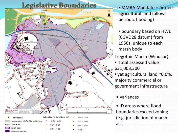
Legislative Boundaries. MMRA Mandate = protect agricultural land (allows periodic flooding) boundary based on HWL (CGVD28 datum) from 1950s, unique to each marsh body. Tregothic Marsh (Windsor): Total assessed value = $31,003,300

E N D
Legislative Boundaries • MMRA Mandate = protect agricultural land (allows periodic flooding) • boundary based on HWL (CGVD28 datum) from 1950s, unique to each marsh body • Tregothic Marsh (Windsor): • Total assessed value = $31,003,300 • yet agricultural land ~0.6%, majority commercial or government infrastructure • Variances • ID areas where flood boundaries exceed zoning (e.g. jurisdiction of marsh act)
Assessment & Engineering Crest Elevations & Footprints • ‘critical’ elevation determined for each marsh body (based on HWL & exposure) • ‘construction’ elevation = 2 ft + critical • in order to maintain slope, as increase height, must increase footprint • Original Fundy design: • 1:3 seaward • 1:2 landward
Town of Wolfville • 210 m < critical • 3.7% of dyke length • foreshore mean = 220 m
Assessment & Engineering Bishop Beckwith Erosion & foreshore marsh • foreshore marsh is critical for erosion protection & source of material (borrow pit) for dyke topping to decrease cost • 1 m water depth – wave dissipation in 80 m Starrs Point
Assessment & Engineering Legislative Boundaries • Important to re-examine marsh body boundary • In many areas, strong match with historical HWL survey and lidar analysis. • However, HWL determined from 1940s and did not consider CC • Extend boundary if minimal development
Protect • hold the line & protect assets • topping requires increase in base footprint, potentially extend dyke • source of material (cost) • armouring (toe of dyke or foreshore) • cost benefit analysis required Source: Pilarsky, 1998
Example of cost assessment for dyke heightening in the Netherlands (van Alphen, 2012) The economic optimum level of protection is where the sum of investments in dikes and residual damage (continuous line) shows a minimum, i.e. where further increase of dike height doesn’t outweigh the related avoided damage anymore.” (van Alphen, 2012). Cost of heightening or damage (M$) Dyke heightening (cm)