Download
1 / 75
760 likes | 1.02k Vues
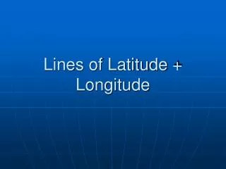
This image is a visualization of the Earth with lines of latitude and longitude shown. How are lines of latitude and longitude drawn on a globe of Earth?. Latitude lines are parallel and longitude lines meet at the poles Latitude lines are parallel and longitude lines meet at the equator

E N D
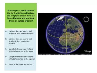
This image is a visualization of the Earth with lines of latitude and longitude shown. How are lines of latitude and longitude drawn on a globe of Earth? Latitude lines are parallel and longitude lines meet at the poles Latitude lines are parallel and longitude lines meet at the equator Longitude lines are parallel and latitude lines meet at the poles Longitude lines are parallel and latitude lines meet at the equator None of the above are correct
On the left side of this satellite image the Indian subcontinent can be seen. In which general direction is this image oriented? North South East West Up
In geography, big numbers are often used. How many millions are there in a billion? 10 100 1000 10000 100000
The figure shows a series of 3 maps of Lancaster, England. Which of the maps is of the largest scale? The map labeled “Level 1” The map labeled “Level 2” The map labeled “Level 3” They are all the same scale They are of different scales, but it is impossible to tell which scale is larger or smaller
An airplane takes off from a location at 17°S latitude and flies to a new location 55° due north of its starting point. What latitude has the plane reached? 28°N 38°N 55°N 72°N 38°S
Base your answer to this question on the topographic map shown here. Points X, Y, and Z are locations on the map. Elevations are expressed in meters.What is the elevation of point Z? 190 m 220 m 240 m 250 m None of the above
On the left side of this satellite image part of the continent of Africa can be seen. A section of desert can be seen there. Whatis the name of this desert? Sahara Desert Gobi Desert Kalahari Desert Mohave Desert Atacama Desert
Which of the following indexes was developed by the United Nations in order to determine the ‘quality of life’ of people in a particular area? Gini Index Human Development Index Gross National Happiness Index Gross Domestic Product Index All of the above
Which two continents can be seen in this satellite image? Africa & South America Asia & Europe North America & Europe North America & Africa None of the above are correct
According to this map, which region in the United States was warmer than average during November and December 2008? Northeast North / Great Lakes Southwest None of the above were warmer during November to December 2008 All of the above were warmer during November to December 2008
The image in this aerial photograph is most likely… …a school …an airport …a ferry terminal …private housing …a hospital
At which grid reference can the lake be found on the map shown here? G5 B2 H1 F4 A4
What does this dot map of China most likely show? The location of mosques in the country Population density Areas of food production Areas with high annual rainfall The distribution of earthquakes in the country
The figure shows the population pyramids for developed and developing countries in the year 2000. Using the populationpyramids, which of the following statements is true? On average, men live longer than women The ratio of young to old is greater in developed countries than in developing countries There is a higher birth rate in developing countries than in developed countries There is a greater death rate amongst 30-34 year olds in developed countries than in developing countries None of these statements are true
According to the wind rose shown here for the city of Seattle, Washington, which of the following statements is true? Most of the wind is blowing from the North to the South Most of the wind is blowing from the South to the North No wind blows from the East Wind speed in Seattle never reaches 17 knots None of these statements are true
Which of the following statements is true about Earth’s radiation balance? Solar radiation is short wave radiation Terrestrial radiation is long wave radiation Not all of the energy from the sun reaches the surface of the Earth Not all of the energy radiating out from the Earth goes back into space All of the above statements are true
Which of the following statements is true about soils? Soils consist entirely of minerals Soils are always more nutrient where there is more rainfall Organic matter is a component of soils Soils are the same throughout the world All of the above statements are true
Which of the climatic conditions below allows for the growth of rainforests? Polar Humid temperate Humid tropical Dry None of the above
Which of the following is NOT a part of the hydrological cycle? Evaporation Precipitation Condensation Radiation Infiltration
This image shows the Mississippi River Drainage Basin. Neighboring drainage basins are separated from each other by… …a river …a ridge …a fault …a sea …a dam
Which of the following river features can NOT be seen in this photo? The river channel A meander An oxbow lake A tributary A point bar
The greatest percentage of fresh water on Earth is found in… …polar ice …groundwater …rivers …lakes …the atmosphere
A chart that compares the discharge of a river with the amount of rainfall over time is called… …a rose diagram …a Lorenz curve …a chi-squared chart …a barometer …a hydrograph
Which of the following countries would see increased rainfall during an ENSO (El Nino Southern Oscillation) event? Indonesia Philippines China Peru Australia
Ocean ridges form where… …tectonic plates converge …tectonic plates diverge …tectonic plates stay stationary …the ocean floor is deepest …the ocean floor is shallowest
An earthquake that occurs at a plate boundary on the ocean floor can cause… …a tsunami …a storm surge …a volcano to form …an island arc to form All of the above
A river of ice and a powerful erosive force on our planet is called… …a glacier …an ice cap …a crevasse …a gorge …an iceberg
Deserts can be found at approximately 25 degrees north and south of the equator because… …of geographic luck; it’s a random occurrence …a continental low pressure belt is found here …these latitudes get the least amount of rain …the sun is hottest at these latitudes …a subtropical high pressure belt is found here
Which of the following processes is most dominant in the formation of the desert arch shown in this image? Water erosion Wind erosion Chemical weathering Acid rain Freeze-thaw weathering
Where do the majority of earthquakes occur? Near the equator Near the poles Near the boundaries of tectonic plates On large land masses Near the world’s megacities
The series of images shows an increase in average night time temperature in the area near Phoenix, Arizona from 1994 to 2004. Which of the following is most likely the cause? Global warming ‘Urban Heat Island’ effect El Nino Southern Oscillation Desertification Tectonics
The images show two mass wasting events in the same location in different years. Which of the following makes a mass wasting event more likely? Very hot summer temperatures Extremely forested slopes Increased amounts of carbon in the atmosphere Heavy rainfall None of the above are correct
In which of the following countries might a sustainable eco-tourism operation be possible which involves whitewater rafting while making a contribution to rice farmers? Saudi Arabia Estonia Philippines Canada Namibia
Which of the following contributes to water scarcity in a country? A lack of rainfall Increased water abstraction (removal) Water pollution None of the above contribute to water scarcity All of the above contribute to water scarcity
Petroleum is most frequently found in… …non-porous igneous rock ….porous metamorphic rock …non-porous sedimentary rock …porous sedimentary rock …porous igneous rock
Which of the following is an example of a renewable source of energy? Coal Oil Natural gas Nuclear power Geothermal power
What factor of the physical environment is most likely to lead people in the Sahel (see image) to immigrate? Tsunamis Drought Earthquakes Volcanoes Flash floods
Why are rivers not the best physical features to choose as a border between two countries? Bridges are difficult and expensive to build Rivers change their course (meander) over time Not all countries have rivers Rivers are only found in the mountains Some rivers are very wide
The Earth is titled on its axis as shown in the image. Given this fact, which of the following statements is true? At certain times of the year there are 24 hours of daylight at the equator South facing slopes receive more solar radiation than north facing slopes in the Northern Hemisphere The Tropic of Capricorn is the midpoint between the Equator and the South Pole All of the above are true None of the above are true
Which of the regions below has the most biodiversity and therefore the most bacteria and disease? Equatorial regions Sub-polar regions Mid-latitude regions Polar regions All of the above regions are the same
How does a sand spit form (see image)? This only happens during a neap tide The only happens during a spring tide Longshore drift and deposition Wave refraction Undercutting of a wave-cut platform
Calcium, Magnesium, Sodium, and Potassium are needed for crop growth. They are all examples of… …rocks …natural elements …minerals …soils …nutrients
Which of the following may explain the lowering of the water table from figure A to figure B in the diagram shown here? Heavy rainfall Water extraction by human beings A drought Both A and B above are correct Both B and C above are correct
Which of the following is a part of the rock cycle? Mountain uplift Erosion Metamorphism Melting & Intrusion All of the above are part of the rock cycle
A person who is personally responsible for high amounts of fossil fuel consumption due to their lifestyle is said to have a large… …ecological footprint …ecological handprint …sustainable footprint …sustainable handprint …sustainable development
The chart shows possible projections for the total world population in the future. Which of the following trends likely leads to a DECREASE in the growth of the world’s population? An increase in contraceptive use More family planning in developing countries Economic growth An increase in the frequency of major global epidemics All of the above are correct
The dependent population of a country is defined as those under 15 or over 65 years of age. Which of the following countries currently has the largest dependent population as a percentage of the working population? Uganda Singapore Japan Italy Argentina
Which of the following is an example of gender inequality in culture? The fact that women live longer than men The fact that there is a large difference in the number of boys and girls born in China under the ‘One Child Policy’ The fact that some families in African countries are larger than those in East Asian countries All of the above are examples of gender inequality None of the above are examples of gender inequality
This map shows the distribution of inequality across the globe as determined by the Gini Coefficient. Countries with a high Gini Coefficient have bigger disparities in wealth than those with a low Gini Coefficient. Use the map to determine which of the following statements is true. On average, South American countries have small gaps between rich and poor people Scandinavian countries have large disparities in wealth Russia has one of the largest disparities in wealth of any country in the world China has greater disparities in wealth than most of its bordering countries None of the above statements are true
Which of the following businesses is most likely to be considered ‘informal employment’? Street vending/Hawking Standard Chartered Bank Nike outlet store An organized food court New York City Private High School