Download
1 / 23
230 likes | 373 Vues
Geoprocessing using GEOLEM and HSPF in the RPC Framework. Vladimir Alarcon Chuck O’Hara. GEOLEM. Library of basic geoprocessing functions, e.g., “flow direction”, “reclassify” Library of complex geoprocessing logic, e.g., “make map of hillslopes”, “make map of affected areas”

E N D
Geoprocessing using GEOLEMandHSPF in the RPC Framework Vladimir Alarcon Chuck O’Hara NASA quarterly briefing
GEOLEM • Library of basic geoprocessing functions, e.g., “flow direction”, “reclassify” • Library of complex geoprocessing logic, e.g., “make map of hillslopes”, “make map of affected areas” • Knowledge handling infrastructure • System to encode modeling knowledge into metadata • Metadata handling infrastructure NASA quarterly briefing
GEOLEM and HSPF • GEOLEM was customized to provide landuse and topographical parameters to be ingested by HSPF • How was it modified? • GEOLEM main code: changes to include new schema files: • config.xml • concept.xml • instance.xml • New methods codes were written: • SlopeHspfMethod.java • LanduseHspfMethod.java • ReclassLanduseHspfMethod.java NASA quarterly briefing
GEOLEM and HSPF NASA quarterly briefing
GEOLEM and HSPF • How was it modified? (continued) • New parameter java codes were written: • LandUseHspfParameters.java • SlopeHspfParameters.java • ReclassHspfLanduseParameters.java • New providers to parameters: • LandUseHspfParametersProvider.java • SlopeHspfParametersProvider.java • ReclassHspfLanduseParametersProvider.java NASA quarterly briefing
GEOLEM and HSPF NASA quarterly briefing
GEOLEM and HSPF • How was it modified? (continued) • New commands were coded into existing JacobCommands class: • SlopePercent • TabulateArea • ReclassHSPF NASA quarterly briefing
GEOLEM and HSPF NASA quarterly briefing
GEOLEM and HSPF • How was it modified? (Version without changes) NASA quarterly briefing
GEOLEM and HSPF getParam: HSPFLanduseArea getParam: HSPFSlope • How was it modified? (changed version) getParam: HSPFLanduseArea getParam: HSPFSlope return: Area return: Slope getDimension: Sub_basin return: Sub_basin Subbasin: HSPFslope OPTIONAL Now the user has the option of re-using EXISTING Delineated subbasins instead of delineating all over again several times ParamHspfSlope ParamHspfLanduseArea Zonal Statistics: Slopes and landuse area per sub-basin LandUseParam.dbf SlopeParam.dbf ASCII HSPF input files NASA quarterly briefing
HSPF in RPC Vladimir Alarcon Chuck O’Hara NASA quarterly briefing
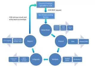
How does HSPF fit into RPC? GEOLEM GenScen WDMutil User Control Input file UCI Watershed boundary polygon Modified GEOLEM Delineated watershed polygon Server’s domain Land use Topography Topography SRTM Land use MODIS, VIIRS Rainfall, ET, Soil Moisture time series User’s domain LIS-generated data: Precip., ET, Soil Moist. NASA quarterly briefing
HSPF in RPC • How can HSPF be used within the RPC environment? • Study the effects of topographical datasets in hydrograph • Some results were presented in previous briefings • Alarcon and O’Hara, 2006 • Alarcon, O’Hara et al., 2006 • Study the effects of landuse datasets in hydrograph • Some results were presented in previous briefings • Diaz, Alarcon, O’Hara, et al. • For this quarterly report we have prepared what could be a typical RPC application using Geolem HSPF • Concurrent effects of landuse and topographical datasets on streamflow hydrograph simulation in a coastal watershed NASA quarterly briefing
HSPF in RPC: research question • Question: if NASA would like to design/launch/release a sensor/mission/product related with topographical and landuse data, what resolution would be useful for watershed hydrology modeling? • A factorial experiment with existing LULC and topography datasets has been performed. • GEOLEM was used to generate 12 concurrent scenarios of topographical/LULC cases for HSPF ingestion. • HSPF was used to simulate streamflow hydrograph for each of these 12 cases. • Those simulated streamflow hydrographs were compared to measured streamflow and the simulated-output reliability was assessed NASA quarterly briefing
HSPF in RPC: factorial experiment • Statistical indicators of fit between HSPF simulated streamflow and measured streamflow • Nash-Sutcliff (NS) number • Coefficient of determination R2 • Model reliability coefficient: Good fit when these coefficients are close to 1 NASA quarterly briefing
HSPF in RPC: Study area • Jourdan River: • Located in the Saint Louis Bay watershed (Mississippi Gulf coast) • Largest contributor of flow to the Saint Louis Bay • Drains 882 sq. km • Average flow: 24.5 cms NASA quarterly briefing
HSPF in RPC: NED & NLCD(GOOD FIT) NASA quarterly briefing
HSPF in RPC: DEM & MODIS(BETTER FIT) NASA quarterly briefing
HSPF in RPC: fit between simulated and measured streamflow NASA quarterly briefing
HSPF in RPC: fit between simulated and measured streamflow NASA quarterly briefing
HSPF in RPC: fit between simulated and measured streamflow NASA quarterly briefing
Conclusions from the experiment • The combination of low resolution topographical datasets (such as DEM, 300m) and low resolution landuse datasets (such as MODIS, 1000m) produce good statistical fit between simulated and measured streamflow hydrographs. • Also: the finer the topographical grid (such as IFSAR, 5m) combined with coarse resolution landuse datasets (such as MODIS or GIRAS) seem to produce good statistical fit. • Medium-resolution topographical datasets(such as SRTM or NED, 30m) combined with medium-resolution landuse datasets (NLCD, 30 m) give the lowest goodness of fit. NASA quarterly briefing
Future steps • Include simulated VIIRS in similar topography/LULC and streamflow hydrograph assessments • Include distributed meteorological forcings in the exploration: • NASA LIS precipitation • NASA LIS soil moisture • NASA LIS evapotranspiration NASA quarterly briefing