
HAZARDS
E N D
Presentation Transcript
All aspects have an IOOS and OOI component, and these problems should provide a great partnership for all the observing communities. This will be the grey zone between research and operational communities, thus many of the Hazard science issues will be the ligament between the OOI muscle and the IOOS bone ORION will need to proactive in building the linkages. ORION is the NSF contribution to IOOS. We will help contribute to the 7 societal goals of IOOS: Detecting and forecasting oceanic components of climate variability Facilitating safe and efficient marine operations Ensuring national security Managing resources for sustainable use Preserving and restoring healthy marine ecosystems Mitigating natural hazards Ensuring public health Here ORION and IOOS can work together to educate the public, and doing this will take an effort by both. Education and Outreach can really benefit from the Hazard focus as it directly impacts their life. In short, what we do will actually matter. All sites contribute to different Hazards so we spent our time on what we could contribute to.
MESOSCALE EVENTS Harmful Algal Blooms, Spills, Coastal Water Quality, Plague & Pestilence (Human Health)¸ Hypoxia, Rip Currents, Beach Erosion, Pollution (including Unexploded Ordnances) Big issues for the community, rip tides are 2nd most effective killer in ocean. Economy of the damage is huge. Nearshore processes impact humans. Spatial issues here are very important, and the pioneer arrays and mobile assets will be a critical tool. Many will require an Endurance line, with assets moving onshore spatially as needed, which will require a responsive shore capability. Surface gravity waves are also fundamental to these processes. Wave initialization for nearshore processes. Shelf observatories will be key to providing the boundaries. Instruments: Biogeochemical sensors, Bio-optical, genomic and immuno-sensors, flow meters, wave buoys, side scan sonar, geophysical seismic measurements, bathymetric surveys to the shore
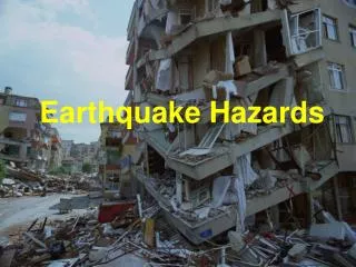
Tsunami, Earthquake, Strong Ground Motion (including volcano) Provide a research footprint for understanding processes that might improve warning capabilities and if a seismic event has generated Tsunami. Data will be freely available so feeding to all interested parties. Dart buoys would be augmented by the RCO for example. The design of the network could be optimized for this, and the presence of the RCO would increase public awareness. The ability to add nodes or expand branching units will be key and should be pursued. This would provide the platform for the research instruments to conduct the basic research for which a framework of offshore warning networks. The ability to monitor small earthquakes to understand processes that might allow improved predictions to (what-when-where). Instruments: Seismic and geodetic, bottom pressure, acoustic arrays, bathymetric surveys
Underwater Landslides What generates land slides? Why do they occur, storm surge, earthquake, methane hydrates, volcanoes, shallow overpressure conditions, etc. Also methane hydrates as a hazard in of themselves, this will require a spatial perspective over time. Small scale events are also crucial issues to be measured. Progress here should leverage all assets (seismology and geodesy) in addition to the OOI. For example, the range of the coastal observatories might allow compare & contrast studies. Instruments: Seismic and geodetic, bottom pressure, acoustic arrays, bathymetric surveys, gas sensors, sub sea floor pore pressure, gas measurements
Hurricanes, Storms Absolutely need surface gravity waves, wind. Locations proposed might be optimized, however current proposed sites will be hit in SAB. The ability to study intensification is not covered if we do not have assets in the Gulf; however the ability to study ocean thermal resource, high wind physics, storm surge, and the impact of the event will be conducted. Improved wind wave physics will also be key to geomorphology processes. An unexamined biological/chemical forcing function. Pioneer arrays may provide a unique tool here. Instruments: Directional wave buoy, pressure sensors, flow meters, anemometers, bathymetric surveys to shore, hydrography, sea floor optics and acoustic imaging, seismic sensors
Hazard to ocean systems and human societies Over fishing, Invasive Species, Sound in the Ocean Monitoring stocks, migration, behavior, larval transport via acoustics (all active and passive) and should be a high priority. An adaptive sampling capability here will be key and mobile assets & pioneer arrays could fuel great studies. Long term ambient noise time series would be extremely interesting at all sites. Here well calibrated sensors will the key to document if it is changing (Ice? Humans? Wind? Climate?). New biosensors will be important for invasive species. Long term time series for fishing issues will hopefully allow us to understand secular, cyclical long term changes, or “degraded” local ecosystems. Improve and build an NJ Turnpike “Easy Pass” for fish. Instruments: Active and passive acoustic arrays, chlorophyll, hydrography, genomic sensors
Hazards to Navigation (unexploded ordnances) , Undersea volcanism, Ice (Scouring, Bergs, etc), Surface gravity waves (wave climates): These represent challenges, and we will contribute to mapping these hazards. However the group believed that this is not a primary ORION goal but we will make contributions (maybe help in ship routing? Tracking?). Instruments: bathymetric surveys to shore, directional wave buoys, hydrography, seismic arrays, sea floor acoustic and optical imaging
Aeolian Dust, Volcanic (Dust), Air Quality, Atmospheric Brown Clouds (ACBs), Atmospheric Pollution Impacts reefs via airborne fungus? We understand very little and ORION will help understand these processes in the atmospheric boundary layer. The entire network should be used and complement other efforts (NASA). How much is coming from Asia? Urban vs pristine locations? Instruments: above water dust sensors, sediment traps, optics and biogeochemical sensors
Climate Change, Sea Level Change, Salinity Changes For the coastal and global efforts this is a central overarching research theme (for example how will continental shelf ecosystems be impacted). Time series to look at the secular versus cyclical processes. We should have good sea level measurements given that the rates of sea level rise is a hot topic of discussion in all ORION components (for example in open ocean, in situ measurements will be cool)!! Great opportunity for partnership (nationally and internationally, send Weller). Ice dynamics and the changes in ocean salinities will be a central research need. Will major current systems change? Instruments: Seismic and geodetic, bottom pressure, acoustic arrays, hydrography, flow meters, biogeochemical sensors
Ocean Acidification, global carbon cycle Ocean acidification effects the ability of the ocean to act as a future sink for short and long term carbon removal by shifting the ocean chemical equilibrium and solubility of CO2 and by reducing and perhaps eliminating many carbonate test bearing plankton species that alter the long term removal of carbon from the ocean. The depletion of carbonate bearing plankton species also removes one of the main food sources for life in the ocean, and thus impacting ocean ecosystem. This is global issue requiring improvements in air-sea fluxes, budgets, etc. The infrastructure will enable study of the potential hazards of these global scale changes. How much carbon can be assimilated by the ocean? Instruments: pH, dissolved gas sensors, gas exchange, optics and biogeochemical sensors
CYBER INFRASTRUCTURE TEAM HELPED GET A LIVE LINK FOR THE HAZARDS TEAM