Download
1 / 69
690 likes | 1k Vues
REGIONAL GEOGRAPHY OF CANADA. Social Studies 9/10 Chapter Notes. CANADA: A REGIONAL GEOGRAPHY What regions are evident?. Five Themes of C anada’s G eography. Location: relative and absolute Place: human and physical Human and Environment Interactions: adaptation, modification, dependence

E N D
REGIONAL GEOGRAPHY OF CANADA Social Studies 9/10 Chapter Notes
Five Themes of Canada’s Geography • Location: relative and absolute • Place: human and physical • Human and Environment Interactions: adaptation, modification, dependence • Movement: migration and transportation • Regions: consistent, focused, aligned, linked
Divisions and Places Placing the Canadian map Political divisions: provinces and territories
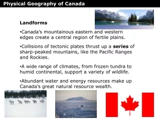
Fundamentals of physical geography • Geology-process, structure, time • Topography-relief, slope • Soils-texture, pH, organic matter • Vegetation-water, arboreal, ecotone • Climate-air mass, current, precipitation, temperature, system
Underlying geology • Pink: precambrian granites • Green: younger sediments • Yellow: faulted and meta-morphized sediments • Blue: older sediments
Glacial legacy • Wisconsin-last ice age, maximum 18,000 yrs. BP • Southern limits-Wisconsin and Ohio Valley • Recedes-15,000-7,000 yrs. BP • Covers virtually all of Canada and northern US • Ice free corridor from Alaska through Yukon into northern BC
Remnant glacial landscapes • Ice margin • End moraine • Glacial lakes • Spillways • Kettle lakes • Eskers • Drumlins • Till plain • Erratic
St. Lawrence Lowlands • Less than 2% of landmass; smallest region • Windsor to Quebec City • Sedimentary geology with glacial deposits • Moderate climate • Fertile soils • Long growing season • Close to the US • Canadian HEARTLAND
Canadian Shield • 50% of Canada’s landmass; largest region • Almost entirely contained in Canada • Geological core underlies North America • Precambrian rocks more than 3 billion yrs. • Exposed granite and shallow soils • Glaciation evident • Mixed Boreal forest • Northern continental climate
Appalachian Uplands • Over 2% of landmass • Northern part of Appalachians • Rounded uplands and plateaux • Numerous islands along drowned shoreline • Narrow river valleys • Rocky, shallow soils • Mixed forests • Cool maritime climate • Short summer wet, winter
Hudson Bay Lowlands • Over 3.5% landmass • Muskeg or wet peat lands • Many lakes • Low ridges of sand and gravel • Poorly drained • Level • Northern climate • Maritime influence • Short, warm summer • Long, cold winter
Interior Plains • About 20% land mass • Geologic base of sedimentary rock • Shaped by glaciation and re-directed drainage • Incised river valleys • Slopes up from east to west with rich soils • Hudson’s Bay watershed • Oil and gas deposits • Continental climate • Moderate to low precipitation
Cordillera • Region of intra-regional differences • About 16% of land mass • Formed 40-80 million years ago from collision of North American and Pacific Plates • Rockies up thrust sediments • Coastal mountains volcanic: ‘ring of fire’ • Glaciers remain in Alpine areas • Fertile valleys and deltas • Coniferous • Multiple micro-climates
Arctic lowlands • About 13% land mass • Coastal plains and lowlands • Islands and drowned shorelines • Sedimentary • Permafrost • Frost action is the main geomorphic process • Polar desert with very low precipitation • Extreme arctic climate conditions
Innuitian Mountains • About 12% land mass • Plateaux and mountains • Extreme glaciation and extensive weathering of sedimentary rock • Extensive coastal drowning and fjiords • Islands • Uplifting and isostatic rebound • Extreme cold • Pack ice and ice flows • Glacier calving
Climate • Continental and maritime influences • Prevailing winds • Jet stream • Mountain effects • Air masses • Freezing point • Seasonal variability • Precipitation • Cloud cover • Evaporation
Where are the people? Population distribution • In cities near the USA • 80% in cities over 100,000 • 80% within 100km of the US border • ‘main street Canada’: Windsor to Quebec City • Agricultural western interior • Coastal and river valley settlement in Atlantic region • Resource points in the Shield and the North • Western cordillera valleys and the BC coast
Canada’s Urban and Agricultural settlement Archipelago • Pattern set over 100 years ago • Islands of population and settlement amid a vast, inhospitable and often empty land • Contrast between heartland and hinterland • Regional centers • Hugging the border • The empty north
The People, Place, Region Relationship • Canada has always had urban centers where most people lived and worked • Urban centers were surrounded by a rural sphere to constitute the heartland • Beyond the rural lands, towns and villages, a sparsely populated resource extraction periphery or hinterland extended to the farthest reaches of the country • With transportation advances people moved to the commuting suburbs of cities
Three Popular Canadian Explanations and One Not So Popular Bilateral Explanation
Canada as a storehouse of raw materials: old and new explanations
Fisheries, then and now: Historic Grand Banks; Pacific Salmon catch and prospects