Download
1 / 1
10 likes | 174 Vues
High impact weather nowcasting and short-range forecasting using advanced IR soundings. P. 586. Objective s To study the needs and unique value of advanced infrared (IR) sounder for severe storm nowcasting and short-range forecasting.

E N D
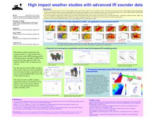
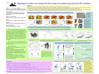
High impact weather nowcasting and short-range forecasting using advanced IR soundings P. 586 • Objectives • To study the needs and unique value of advanced infrared (IR) sounder for severe storm nowcasting and short-range forecasting. • To demonstrate the value of a high temporal and spatial resolution advanced IR sounder on storm nowcasting by depicting atmospheric structure and instability in the pre-convection environment. • To improve the short-range forecasting by assimilating the high spatial resolution advanced IR soundings in regional numerical weather prediction (NWP) models. • To use Atmospheric InfraRed Sounder (AIRS) and Infrared Atmospheric Sounding Interferometer (IASI) full spatial resolution soundings for high impact weather (storms, hurricanes) applications. • (5) To understand the better application of combined GOES-R/S ABI and advanced IR sounding products for high impact weather nowcasting and short-range forecasting. Jun Li (Jun.Li@ssec.wisc.edu) Cooperative Institute for Meteorological Satellite Studies (CIMSS), University of Wisconsin-Madison, Madison, WI Timothy J. Schmit NOAA/NESDIS, SaTellite Applications and Research (STAR), Advanced Satellite Products Branch (ASPB) Madison, WI Jinlong Li, and Jason Otikin CIMSS, University of Wisconsin-Madison, Madison, WI Hui Liu National Center for Atmospheric Research, Boulder, CO Jing Zheng CIMSS, University of Wisconsin-Madison, Madison, WI Bing Lu and Bin Wang Institute of Atmospheric Physics, Beijing 1. Geostationary advanced IR sounder simulation for HIW – an application to pre-convection storm warning The AIRS lifted index (color) at 0635 UTC 07 August 2010. The left panel is the relative humidity profile over the Zhou Qu. AIRS single field-of-view 500 hPa temperature (color regions in upper panels) and water vapor mixing ratio (color regions in lower panels) overlaying the 11 µm BT (B/W) at 1840 UTC (right panels) and 2015 UTC (left panels) on 07 August 2010. This storm led to a massive mudslide in Zhou Qu area, which caused 1456 deaths and left another 309 missing. WV The lifted index (LI) from true field (upper left), HES-like observations (upper right), ABI/GOES Sounder like observations (lower left), along with the simulated radar image (lower left) at 1300, 1700, and 2100 UTC, respectively, on 12 June 2002 during IHOP. 2. Regional assimilation of advanced IR soundings for hurricane/typhoon forecast with WRF/DART • Full spatial resolution temperature and moisture profiles (12 ~ 13.5 km at nadir) from AIRS, IASI and simulated geostationary advanced IR sounder radiances with CIMSS hyperspectral IR Sounding Retrieval algorithm (CHISR) have been used to study the pre-convection storm nowcasting. The International H2O Project (IHOP) case and the Zhou Qu storm case are used to demonstrate the value of warning information from advanced IR soundings in the pre-convection environment. • The full spatial resolution AIRS soundings have been used for storm, hurricane and typhoon forecasting through assimilation. • Our results show that • AIRS water vapor soundings improve the 24 hour precipitation forecast; • AIRS temperature and water vapor soundings improve both the track and intensity forecast for Hurricane Ike (2008) and Typhoon Sinlaku (2008) with both WRF/DART and WRF/3DVAR simulation and forecast systems; • AIRS temperature and moisture soundings significantly improve the definition of the typhoon vortex in the analysis and the forecast of the rapid intensification for Sinlaku. Without AIRS With AIRS AIRS full spatial resolution sounding data used in assimilation Track (left) and sea level pressure (right) analysis during assimilation period (two days) with AIRS full spatial resolution soundings. Control run already contains radiosonde, satellite cloud winds, aircraft data, and surface data. Track forecast without (left) and with (right) AIRS full spatial resolution sounding data 96-hour track forecast error without (left) and with (right) AIRS full spatial resolution soundings. 3. Assimilation of advanced IR soundings for hurricane forecast with WRF/3DVAR CTRL(without 3DVAR) run with 6-hour NCEP Final Operational Global Analysis data (1.0x1.0 degree). Spatial resolution for WRF is 36 km in the initial experiment. AIRS used in Typhoon assimilation WRF/DART ensemble assimilation system 32 ensembles, 36 km resolution. One day (10 September 2008) AIRS assimilation followed by 48-hour forecast (12 UTC 09 – 12 UTC 11 September 2008). Lower left panel shows the Sinlaki track forecast without and with AIRS full spatial resolution temperature and moisture soundings. Rapid intensification is captured with AIRS. AIRS (with 3DVAR) run uses clear-skies from 3 granules g066/067/068, but only assimilate 8 layers of T profiles between 600~800hPa in the initial experiments for next 48 hour Hurricane Ike (2008) track forecast. 4. Regional assimilation of AIRS SFOV soundings for improving precipitation forecast • 5. References • Li, J., H. Liu, 2009: Improved Hurricane Track and Intensity Forecast Using Single Field-of-View Advanced IR Sounding Measurements, Geophysical Research Letters, 36, L11813, doi:10.1029/2009GL038285. • Schmit, T. J., J. Li, S. Ackerman, J. Gurka, 2009: High-Spectral- and High-Temporal-Resolution Infrared Measurements from Geostationary Orbit, Journal of Atmospheric and Oceanic Technology, 26, 2273 – 2292. • Liu, H., and J. Li, 2009: An Improvement in Forecast of Rapid Intensification of Typhoon Sinlaku (2008) Using Clear Sky Full Spatial Resolution Advanced IR Soundings, Journal of Applied Meteorology and Climate, 49, 821 - 827. • Li, J., Jinlong Li, T. Schmit, J. Otkin, and C. Liu, 2011: Warning Information in a Pre-Convection Environment from the Geostationary Advanced Infrared Sounding System—A Simulation Study Using the IHOP Case, Journal of Applied Meteorology and Climate (in press) • Acknowledgements:This study is partially supported by NOAA GOES-R program. The views, opinions, and findings contained in this report are those of the authors and should not be construed as an official National Oceanic and Atmospheric Administration or U.S. Government position, policy, or decision. 24-hour precipitation (00 UTC 22 – 00 UTC 23 July 2009) forecast was improved when AIRS full spatial resolution water vapor soundings. One out of 2 X 4 AIRS FOVs is selected, only 1/8 clear sky pixels are used in the assimilation. AIRS overpass time: 18:23 – 18:29 UTC 21 July 2009. CTRL run uses the NCEP analysis as initial. The regional NWP model is GRAPES_Meso2.0. This work is ongoing through collaboration between CIMSS and Institute of Atmospheric Physics.