Spatial sampling strategy
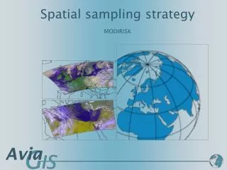
Spatial sampling strategy. MODIRISK. Basis for sampling strategy. Grid of 10X10 km = 326 cells Three samples per grid cell = 978 samples Take into consideration: Major biotopes Seasonal variation Import risk . Proposed procedure.


Spatial sampling strategy
E N D
Presentation Transcript
Spatial sampling strategy MODIRISK
Basis for sampling strategy • Grid of 10X10 km = 326 cells • Three samples per grid cell = 978 samples • Take into consideration: • Major biotopes • Seasonal variation • Import risk MODIRISK Kick-off-meeting
Proposed procedure • Identify key habitats based on Corine LC classes by aggregating urban, agriculture, natural and import risk classes. • Calculate total surface per aggregated class • Assign proportional number of sample points to aggregated class. • Generate appropriate number of random sampling points within each class. • Randomly assign sampling points within each class to two sampling seasons. • Geocode and assign sample sites per team. MODIRISK Kick-off-meeting
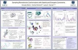
Aggregation of CORINE LC data • CORINE includes 50 classes divided in five groups: • Artificial surfaces including urban and industrial • Agriculture areas • Forest and semi natural areas • Wetlands • Water bodies MODIRISK Kick-off-meeting
Corine data – 50 classes MODIRISK Kick-off-meeting
Class aggregation • (1) Urban biotopes • (2) Land in the agriculture cycle • (3) Natural terrestrial habitats • (4) Risk of introduction areas: ports, airports, dump sites, moors and heat land, inland marshes, salt marshes • (5) Areas excluded from sample: industrial and commercial units, roads, mines and mineral extraction sites, construction sites, sparsely vegetated areas • (6) Water bodies MODIRISK Kick-off-meeting
Corine - 6 aggregated classes MODIRISK Kick-off-meeting
Sample size per aggregated class In blue = automated random assignment In red = manual attribution in selected areas MODIRISK Kick-off-meeting
173 random urban sampling points MODIRISK Kick-off-meeting
564 random agri sampling points MODIRISK Kick-off-meeting
199 random natural sampling points MODIRISK Kick-off-meeting
Non-random sampling points • Not yet included in map • 42 sampling points to be allocated in areas representing a particular risk of introduction: ports, airports, dump sites, moors and heat land, inland marshes, salt marshes. • Additional samplings should also be conducted in other selected areas: • Zoos and safari parks (list available) • Second hand tire import/storage (list to be established) • Protected areas involving presence of large numbers of migratory birds (list available) MODIRISK Kick-off-meeting
Sample: institute / year / season MODIRISK Kick-off-meeting
Sample per institute • Rough division by province: • ITG (274 + 42): Antwerp, Limburg, Brabant • KBIN (293): Oost Vlaanderen, West Vlaanderen, Brabant • UCL (365): Hainaut, Namur, Luxembourg • Needs reassessment !!! MODIRISK Kick-off-meeting
Data base • Flexibility to re-allocate sampling areas • Geocode random sampling points to nearest relevant feature to ease sampling: road access, street names, house numbers, … • UTM numbering grid cells according to standard MODIRISK Kick-off-meeting
Web based MODIRISK survey map • Online map (Google map) with status of field survey per team • Public access: important dissemination purpose because most urban samples will be conducted in house gardens • Link to entomological data base future link with biodiversity data base • Password protected centralized data entry using Palmtop: • Field forms • Entomology forms • Cross check forms • Generate addresses in urban areas to contact prior to sampling MODIRISK Kick-off-meeting
www.avia-gis.com ghendrickx@avia-gis.be