SIGMET
SIGMET. These messages are intended to provide short term warnings of certain potentially hazardous weather phenomena. Warnings are issued for: active thunderstorm areas, lines of thunderstorms, heavy hail, severe turbulence or icing, marked mountain waves, hurricanes,

SIGMET
E N D
Presentation Transcript
SIGMET • These messages are intended to provide short term warnings of certain potentially hazardous weather phenomena. • Warnings are issued for: • active thunderstorm areas, • lines of thunderstorms, • heavy hail, • severe turbulence or icing, • marked mountain waves, • hurricanes, • widespread sand or dust storms, • volcanic ash, • and low level windshear.
SIGMET • Sigmets are meant especially to warn pilots who are already flying about severe weather • Sigmets are broadcast by VFR and IFR air traffic control units, FSS, and are available on the Navcanada weather website.
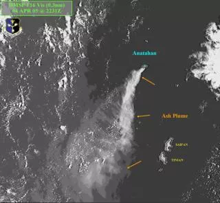
SIGMET WSCN31 CWTO 250430 SIGMET A1 VALID 250430/250830 LN TSTMS 30NM WIDE MAX TOPS 400 OBSRVD AT 0400Z FROM LONDON-TORONTO-PETERBOROUGH. LN MOVG SWD ABT 20 KTS AND INTSFYG. TSTMS MOVG OUT OF AREA BY 0730Z. Significant Meteorological Report Severe Icing or Turbulence not associated with convective clouds Large area for dust storm or sandstorm (most likely in the Prairies) Possible volcanic ash clouds, hurricanes and tropical storms (uncommon in Canada)
SIGMET Line of thunderstorms or active area of thunderstorms Severe Squall Line Mountain Waves (mostly Rockies) Heavy hail (rarely) Tornado or Water Spout Low level wind shear
PIREPs (PIlot REPorts) • PIREPs are reports of weather conditions encountered by aircraft during flight. • Pilots are encouraged to file brief reports of weather conditions especially reports of any significant atmospheric phenomena that differ from forecast. • PIREPs are usually reported to Flight Service Stations but can be passed along to Air Traffic Control as well.
PIREP (AIM MET 2-0) UACN10 CYXU 032133 YZ UA /OV YXU 090010 /TM 2120 /FL080 /TP PA31 /SK 020BKN040 110OVC /TA 12 /WV 030045 /TB MDT BLO 040 /IC LGT RIME 020040 /RM NIL TURB CYYZ CYHM TRY TO DECIPHER THIS FOR YOURSELF Go to: http://www.tc.gc.ca/civilaviation/publications/tp14371/met/3-0.htm#3-17 to see how you did!
PIREPS • Significant weather that can be reported by PIREP includes, but is not limited to: • Clear Air Turbulence • Wind Shear • Airframe Icing • Volcanic Ash • Pilot Estimation of Surface Wind
Levels of Turbulence (AIM-MET 3.7) • NOTES 1: Occasional: Less than 1/3 of the time. Intermittent: 1/3 to 2/3. Continuous: More than 2/3.
Icing types Clear Ice (there is a bit of mixed here too) Rime Ice