Weather Model Development for Aviation
This overview discusses the development of advanced weather modeling techniques for aviation, specifically highlighting the NOAA HRRR (High-Resolution Rapid Refresh) model. Led by experts Stan Benjamin and Steve Weygandt, the HRRR model is crucial for accurate short-term weather predictions. The presentation reviews the significant derecho event that occurred on June 29, 2012, in the Mid-Atlantic, demonstrating the model's real-time assimilation of radar data and its enhanced resolution capabilities. The ongoing evolution of these models aims to improve forecasting accuracy and situational awareness for aviation safety.


Weather Model Development for Aviation
E N D
Presentation Transcript
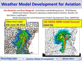
Weather Model Development for Aviation Stan Benjamin and Steve Weygandt: Assimilation and Modeling Branch, Chief/Deputy NOAA Earth System Research Laboratory, Global Systems Division, Boulder, CO Stan/Steve: Lead/Expert Model Development and Enhancement Product Development Team, AWRP/FAA Observed radar 03z June 30 2012 12h NOAA HRRR model forecast Valid 03z NOAA/ESRL/GSD 30 Oct 2013 Aviation Model Development
An Important Pinpoint Prediction Challenge: The 29 June 2012 Mid-Atlantic Derecho A fast-moving damaging wind event… Start HRRR run 11 AM 2 PM 4 PM 6 PM 8 PM 10 PM MID 700 mile long swath of damage, 5 million without power, 22 fatalities
Computer weather modeling: What is thepotential? 29 June 2012 – Mid-Atlantic/DC thunderstorm/derecho event HRRR 2012 derecho loop HRRR forecast initialized 15z (11am Eastern Time) Observed radar
Computer weather modeling: How is it done? 1800 points Model Equations 50- levels Weather computer model: Solve physics equations at many points repeatedly to mimic time-evolution of 3-D of temperature, wind, moisture, clouds, etc. 1060 points 1800 x 1060 points x 50 levels = 95,000,000 3-d points every 20 seconds Model Terrain
NOAA Next-Generation Model Development RAP • RAP - Rapid Refresh • NOAA “situational awareness” model for high impact weather • New 18-hour forecast each hour • NOAA operational – 1 May 2012 • Hourly use by National Weather Service, Storm Prediction Center, FAA, private sector • HRRR – High-Resolution Rapid Refresh • Next-generation storm/energy/aviation guidance • New 15-h forecast each hour • Real-time experimental on ESRL supercomputer • Open ftp access HRRR
RAPand HRRR data assimilation RAP Hourly cycling model EnKF- Hybrid + Radar and Cloud anx Radar and Cloud anx + 3DVAR Data Assimilation cycle Observations HRRR
Operational Prediction Process Data Assimilation Objective Analysis (adjust background) Observations AnalysisUpdateCycle Statistical post-processing (downscaling, probability) Model Prediction Human Forecaster
Rapid updating – Why do it? HRRR (and RAP) Future Milestones HRRR Milestones More frequent model updates with newer obs Smaller adjustments 12-h update to previous forecast Better forecasts 12-h fcst 9-h fcst 3-h update to previous forecast 6-h fcst 3-h fcst Truth Next forecast time noon 6 AM 9 AM 3 PM 6 PM
Rapid update cycling with latest observations improves short-range forecasts (including upper-level winds) Benefits of Rapid Cycling NWP 12-h fcst wind errors 3-h fcst wind errors 6-h fcst wind errors ORD ORD ORD LAX LAX LAX RUC jet-level (35 kft) wind forecast errors NOAA/ESRL/GSD 12 July 2012 NOAA/ESRL/GSD 30 Oct 2013 Aviation Model Development Aviation Model Development 9
RAP error reduction to 1-h forecast Rapid Refresh Wind forecast accuracy vs. forecast length 1h 6 3 12 18h 1 Jan - 7 Mar 2012 - Verification against weather balloon data The Rapid Refresh isable to use recent obs to improve forecast skill down to 1-h projection NCEP Production Suite Review NOAA/ESRL/GSD Rapid Refresh / HRRR 4-5 December 2012 30 Oct 2013 Aviation Model Development 10
Rapid RefreshHourly Update Cycle Partial cycle atmospheric fields – introduce GFS information 2x/day Cycle hydrometeors Fully cycle all land-sfc fields (soil temp, moisture, snow) 1-hr fcst 1-hr fcst 1-hr fcst Back- ground Fields Analysis Fields 3DVAR 3DVAR Obs Obs Time (UTC) 11 12 13
Observations assimilated in hourly updated models (Rapid Refresh)- All used to initialize 3km HRRR Radar reflectivity
High Resolution – Why do we need it? HRRR (and RAP) Future Milestones HRRR Milestones Thunderstorm ~3km horizontal resolution needed to “resolve” thunderstorms RAP HRRR
High Resolution – Why do we need it? HRRR (and RAP) Future Milestones HRRR Milestones Thunderstorm ~3km horizontal resolution needed to “resolve” thunderstorms ~3km horizontal resolution needed to “resolve” thunderstorms …but 4x resolution costs 64x computer power RAP HRRR
3-km HRRR – what it gets you... HRRR (and RAP) Future Milestones HRRR Milestones 13-km 6hr forecast HRRR 6hr forecast 13-km Resolution Parameterized Convection 3-km Resolution Explicit Convection 07 June 2012 ACCURATE STORM STRUCTURE ACCURATE ESTIMATE OF STORM PERMABILITY NO STORM STRUCTURE NO ESTIMATE OF STORM PERMEABILITY 5 PM EDT observed
Radar data assimilation: Getting storms in the right places Radar Obs 06:00z 18 May 2013 05z + 1 hour 1-hr fcstradar DA (13-km and 3-km) 1-hr fcstNO radar DA
Radar data assimilation: How it works for RAP and HRRR • Run model backwards in time (reversible processes only) • Run model forward in time (heating from radar observations) • Digital filter after backward and forward step -20 min -10 min Initial +10 min + 20 min NO backward step or filter for HRRR Backwards integration, no physics Forward integration,full physics with obs-based latent heating Initial fields with improved balance, storm-scale circulation RAP / HRRR model forecast
Radar data assimilation: How it works for RAP 00z init 00z 12 Aug 2011 Reflectivity RAP HRRR RADAR RAP HRRR no radar Convergence Cross-Section Rapid convective spin-up with radar data
Radar data assimilation: How it works for RAP +1 hr fcst 01z 12 Aug 2011 Reflectivity RAP HRRR RADAR RAP HRRR no radar Convergence Cross-Section Rapid convective spin-up with radar data
Cloud and Hydrometeor Analysis Adjust cycled explicit cloud fields using METAR and satellite data YES HM Hydrometeor designation from radar 29thConf on EIPT (IIPS) NOAA/ESRL/GSD High-Resolution Rapid Refresh 08 January 2013 30 Oct 2013 Aviation Model Development 20
Detailed, precise short-range weather guidance needed for: Rapid cycling NWP Data Assimilation and Rapid Cycling Numerical Weather Prediction (model) • Air transportation (NextGen) Data Assimilation Cycle • Required for improved weather guidance for: • Turbulence • Ceiling/visibility • Convective weather • Icing • Terminal/enroute weather • Safety and efficiency Observations
Aviation hazard forecasts – all based on RAP and HRRR models (out to 15-18h) Hourly updated 13km Rapid Refresh model forecasts (development supported by FAA/MDE, NOAA) Refreshing from latest observations every hour gives better accuracy
1800 points Subset of full domain Weather computer model: Solving physics equations on many points repeatedly to provide 3-D forecast forecast of temperature, wind, moisture, clouds, etc. 1060 points An example of computations needed 1800x1059x50 grid points = 95 E6 grid points x 50,000 floating pt ops per grid point = 4.75 E12 FPA / time step x 2160 time steps / 12h forecast = 10 E15 FPA / 12h forecast 10,000,000,000,000,000 calculations for one 12h HRRR CONUS forecast
RAP and HRRR Resources CW Overview Meeting NOAA/ESRL/GSD High-Resolution Rapid Refresh 12 June 2012 12 July 2012 NOAA/ESRL/GSD 30 Oct 2013 Aviation Model Development Aviation Model Development 24 24