NJ iMap 2.0 and NJ BASINS
290 likes | 496 Vues
NJ iMap 2.0 and NJ BASINS. Paul Morton Water Monitoring & Standards Marzooq Al-Ebus Division of Watershed Management. Overall Use of STORET in NJ. Began using STORET in 1970s Currently storing ambient chemical, benthic macroinvertebrate, fish and data logger results

NJ iMap 2.0 and NJ BASINS
E N D
Presentation Transcript
NJ iMap 2.0 and NJ BASINS Paul Morton Water Monitoring & Standards Marzooq Al-Ebus Division of Watershed Management
Overall Use of STORET in NJ • Began using STORET in 1970s • Currently storing ambient chemical, benthic macroinvertebrate, fish and data logger results • Since 1998, over 3,300 stations, 600,000 results • Used for required Integrated Water Quality Report (303 (d) & 305(b)) to USEPA and for TMDL development
NJDEP/USGS-NJ NWIS Data • Entered 3 years of cooperative network results in NJ STORET (only a part of NJDEP’s monitoring program) • Eliminated practice w/Region 2’s approval • Duplicate entry = skewed results for users retrieving data from both databases • No proofreading and USGS staff limitations • Shifted resources to getting data not in a public database into STORET so publicly available for Integrated Assessment Report
Window to My Environment • Advantages: • “One stop shop” for NWIS & STORET data • Access to data not in NJ-STORET (DRBC, EPA, IEC) • Map based and available to the public • Disadvantages: • Different data formats: must reformat to merge • Only one station of data per retrieval • No Legacy STORET data
Plans for NJ-STORET and CDX • Will be applying for FY06 NEIEN Grant funding for multiple data flows to NJ-STORET • NJ State LabNJ-STORET (expanding eDWR) • NJ-STORETEPA-STORET? • May create a Web site/Web service for receiving 319(h) grant & volunteer data from groups not running STORET per Region 2 guidance • Learn from Pacific Northwest and USGS XML-based data sharing efforts so don’t reinvent the wheel
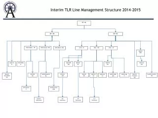
i-MapNJ ArcIntelligence 2.0 “Integrating GIS with NJDEP Databases” Business Objects Web Intelligence BRIDGE i-MapNJ NJEMS Facility Data (DMRs, Permits, Violations) NJ STORET Ambient Water Quality & Bio Data GIS SpatialData
Basic Function of i-MapNJ (Intranet) • Builds a Bridge between Tabular Data and Spatial Data • Improves Environmental Decision-Making • Puts GIS & Data Viewer on EveryNJDEP Desktop • Introduces a “User Profile” concept • Integrates additional environmental data • Deploys additional GIS tools; Improves performance • Employs State-of-the-Art Intranet Mapping Software • Answers spatial questions that were previously unanswerable (not having a discoverable answer)
Set Filters on WEBI Report to find Results Exceeding the Standard
NJ Perspective on Needed National STORET & Related Enhancements • Common format for data exchange (XML schema for STORET) to eliminate current wasteful practice of manually reformatting data • Automate 2-way data exchange (CDX client node] between Federal agencies (STORET and NWIS] and states/tribes to eliminate wasteful manual process • NEIEN Grant funds for states to implement STORET CDX nodes or we won’t be able to implement efficiencies offered by NEIEN initiatives • STORET GIS Web Service to make monitoring stations available via common format and eliminate manual creation of GIS data layers. Multiple agencies create GIS data clearinghouses that point to Web Services = broadest possible exposure for STORET data • Web links for reports currently disappear after 30 days. Make Web links for Data Logger files permanent so we can link to them from our Web sites rather than having to store the data on our Web sites
NJ Perspective on Needed National STORET/WME Enhancements • STORET/Window to My Environment • Add ability to download multiple station results rather than the exhausting “one at a time” process • Normalize output formats for STORET and NWIS (ex: units of measure, how “Non-detects” are treated, etc.) so end user can spend less time reformatting data and more time assessing results and developing TMDLS • Add link to Legacy STORET data for users needing to do long term trend analysis and indicator/surrogate studies rather than forcing them to go to 2 Web sites and reformat data.
Needed STORET Enhancements • Make STORET a fully functional database by eliminating wasteful practices and enhancing processing of batches of information freeing resources to enter additional data: • Add the ability to change a group of results (batch processing) from “Preliminary” results that are not visible on the Web to “Final” results that are, without having to manually change each result or delete/reenter results. • Ability to add add, change or delete results for a group of existing samples (batch processing) rather than doing it “one at a time” • Ability to share custom set-ups that increase the efficiency of data entry (share Preference & Defaults) between agencies
Needed STORET Tools • Web based application (SIM Web?) for accepting/reformatting data for groups (contractors, grantees, academia, volunteers] not using STORET so they can make their data publicly available and therefore valid for inclusion in Water Quality Assessments. • Application to include all necessary information for STORET including Organization information, and preference/default codes that must be entered manually into a local copy of STORET (problem for those who don’t have STORET • Update SIM (the STORET Interface Module) so it can accept this additional information saving time and effort from manual steps and freeing resource to enter other data that doesn’t exist in a public database.
BASINS-NJ • Customized version of EPA BASINS 2.0 for WQ data analysis, TMDL modeling and implementation • Additional GIS data (Land Use, Impervious Cover, etc.) • Additional models (Mercury and Sediment) • Additional assessment tools • Low flow analysis tool • Watershed characterization report • Improved target and assess tool • Download and/or compile water quality data from multiple sources (USGS-NWIS, NJ-STORET, third-party data source • Basins-NJ version 1 was delivered on June, 2004 and is currently undergoing testing
BASINS-NJ Issues • ArcGIS • NJDEP switching from ArcView 3.x environment to ArcGIS 8.x, 9.x and establishing ArcGIS as the only GIS approved platform for the agency. • An option is to create a version of BASINS-NJ that runs on ArcGIS - this will involve a significant rewrite of the BASINS-NJ ArcView 3x Avenue scripts to VBA and ArcObjects or migrating to BASINS 4.0 when released by EPA.
BASINS-NJ Issues During Testing Phase • System errors • Error Codes- No user-interpretable information • BASINS Extensions may lock the system when multiple extensions are loaded • Some extensions use common dialogs and same name • Low Flow Analysis • Single day low flow is greater than an average 7 day low flow- 1Q10> 7Q10
BASINS-NJ Issues • Data Duplication • NWIS and Legacy STORET data • Data entered into both data systems • BASINS-NJ was not designed to handle this automatically. • User has to review combined data manually to remove data duplicates.
Potential BASINS-NJ Enhancements • Update data and provide tools to automatically update data • Population • Water quality and flow stations • Meteorological data (new WDM files) • Automatically refresh stations list from USGS-NWIS and EPA-STORET
Potential BASINS-NJ Enhancements • Include new models • STEPL • GWLF • AQUATOX • Enhance current download tools to include: • Refresh/update NWIS stations • Connect and download EPA-STORET data and stations • Provide tools to identify potential data duplicates from multiple data sources • Tools to archive and restore BASINS projects (available in BASINS 3.1)
NJ’s Perspective on STORET & BASINS Now, and its promise for future. • NJ has used STORET for multiple water quality networks and types of monitoring (chemical & biological) for over 4 decades, • NJ enthusiastically supports STORET as a National Water Quality Data Base useful for meeting EPA requirements, especially Integrated Assessments, trends and TMDLs. • Urgent need to develop automated data exchange between EPA/STORET, USGS/NWIS and states, tribes, academia and volunteers to eliminate extremely wasteful current practice of reformatting data and manual data sharing. • Key enhancements are needed in the areas of importing data, editing and deleting results so that STORET is a fully functional national DB and BASINS is a comprehensive assessment tool for states, tribes, academia, volunteers and public.