Coastal Mapping of Sordyroy and Breidflua: Geographical Coordinates Overview
This comprehensive report details various coastal points in the Sordyroy and Breidflua regions, highlighting significant geographical coordinates and features. The report includes various locations such as Slettflua, Langskjerklakkan, and Andsteinen, along with their respective altitudes and precise GPS coordinates. This data is essential for navigation and ecological studies in these coastal areas, providing insights into both natural and sandy terrains.

Coastal Mapping of Sordyroy and Breidflua: Geographical Coordinates Overview
E N D
Presentation Transcript
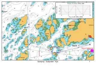
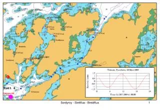
Rutt 4 Sordyroy - Slettflua - Breidflua
42 Slettflua 63 48.871N - 8 45.153E 43 59m Dragnessvaet (sand) 63 48.391N - 8 43.979E 44 Langskjerklakkan 63 49.136N - 8 45.281E 45 Langskjer(sand) 92m 63 49.104N - 8 45.642E 46 Kariholmen 47m 63 49.428N - 8 46.223E Sordyroy - Slettflua - Breidflua
41 NO Breidflua 49m 63 50.812N - 8 49.427E 46 Kariholmen 47m 63 49.428N - 8 46.223E 47 Breidflua 63 50.573N - 8 48.626E 48 Andsteinen 74m 63 50.506N - 8 46.626E 49 Hegresteinsrevet 63 51.781N - 8 48.761E 50 SV Hegresteinsrevet 46m 63 51.488N - 8 47.526E 51 N Bleiktaren 63 50.190N - 8 52.776E Sordyroy - Slettflua - Breidflua