How Landforms are Created
How Landforms are Created. Introduction. It's no wonder the discovery of plate tectonics is considered one of the greatest scientific achievements of the 20 th century. This process explains how many of the features on the surface of the lithosphere came into being.

How Landforms are Created
E N D
Presentation Transcript
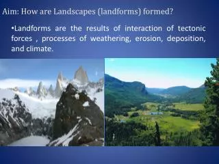
Introduction • It's no wonder the discovery of plate tectonics is considered one of the greatest scientific achievements of the 20th century. • This process explains how many of the features on the surface of the lithosphere came into being. • The word "tectonic" comes from the Greek word for carpenter • This term is appropriate since both tectonic forces and carpenters are builders of sorts – one of the main differences between them begin the size of their creations. • The extreme pressure caused by plates drifting across the earth's surface and crashing into one another is responsible for forcing many major landforms into shape.
Landform Types • There are essentially six different types of landforms on the earth's surface • Each landform is defined by its elevation and surface relief. • Elevation refers to a landform's height above sea level • Ex. Mountains have the highest elevation and valleys have the lowest. • Relief refers to the surface of a landform. • Ex. A feature is said to have a low relief if it is flat, and a high relief if it is rough, hilly, or jagged.
The characteristics and Formation of the different Landforms • Landform Types: • Mountains • Description: • Rugged peaks of varying heights and steep slopes • Elevation: • High • Relief: • High • How it is formed: • Tectonic folding, faulting, and volcanism Rocky Mountains
The characteristics and Formation of the different Landforms • Landform Types: • Highlands • Description: • Like mountains, but all the peaks are at the same height • Elevation: • High • Relief: • High • How it is formed: • Isostatic uplift followed by millions of years of erosion Ethiopian Highlands Isostatic uplift: the slow upward movement of the lithosphere caused by the release of surface pressure.
The characteristics and Formation of the different Landforms • Landform Types: • Plateau • Description: • High, flat table land • Elevation: • High • Relief: • Low • How it is formed: • Isostatic uplift – often extrusive former lava flows. Plateau of Tibet
The characteristics and Formation of the different Landforms • Landform Types: • Hills • Description: • Rounded mounds of no particular shape • Elevation: • Medium • Relief: • Medium • How it is formed: • Either old worn down mountains or depositional features Appalachian Mountains
The characteristics and Formation of the different Landforms • Landform Types: • Plains • Description: • Low, flat land • Elevation: • Low • Relief: • Low • How it is formed: • Former sea floor uplifted, or deposited material from mountain erosion The Great Plains
The characteristics and Formation of the different Landforms • Landform Types: • Valley • Description: • Low, flat land surrounded by hills or mountains • Elevation: • Low • Relief: • Low • How it is formed: • Faulting, folding, or river erosion Tibet Valley
Landforms are Created through Isostatic Movement • Isostasy: • The movement of surface features up or down in response to the plasticity of the asthenosphere. • If a great mass is removed from the earth's surface, as in the melting of a continental glacier or the drying up of an ocean, the earth's surface rebounds or rises up in response to the decreased pressure on the asthenosphere. • This process is often the reason why fossil fuels such as coal may be located near the earth's surface and far away from any oceans.
Mountain Building • Mountain building, also known as orogeny, is an involved process lasting hundreds of millions of years. • Some basic definitions: • Mountain: • An area of land that rises abruptly from the surrounding region. • Mountain Range: • A succession of many closely spaced mountains covering a particular region of the Earth. • Mountain Belt: • Consist of several mountain ranges that run roughly parallel to each other. • Ex. The North American Cordillera, the Himalayas, the Alps, and the Appalachians are examples of mountain belts
Mountain building Occurs in 3 Stages: Accumulation of sediments A mountain building period of rock deformation and crustal uplift A period of crustal uplift caused by isostatic rebound and block-faulting
Mountains are Formed in 3 ways: • Folding • Faulting • Folding and faulting occurs when pressures deep within the lithosphere caused the earth's surface to buckle, bend, and even split apart. • Volcanism • Occurs when solid rock structures are created from molten rock. Created above or below the earth's surface. • Rarely are mountains formed by only one of these processes – usually all three are involved.
Landforms Created Through Folding • Folding occurs when the earth’s curst is pushed up from either or both sides - associated with convergence boundaries (destructive and collision margins)
Folded Features • Fold mountains at destructive margins occur where oceanic crust is subducted underneath the continental plate, forcing the over-riding plate to crumple and uplift - the resulting folding and faulting results in the formation of a mountain chain roughly parallel to the oceanic trench - e.g. the Andes Mountains. • Fold mountains at a collision zone occur as the colliding plates resist subduction and uplift occur with folding and faulting - e.g. the Himalayas. • Valleys – Where the curst folds down
The structure of fold mountains can be complex, the simplest fold mountains are made up of layer of rock that rise and fall like waves of water. The Peaks (hills) are called Anticlines; the troughs (valleys) are called Synclines.
Landforms Created Through Faulting • Occurs from blocks of rock either fracture or pull apart. • Occur whenever a plate is under tension or compression • Tension: the pulling apart of plates • Compression: when plates ram into each other
Faulting Features • Extension fault: The mid-oceanic ridge – where two plates are pulled away from each other – ridges on the ocean floor • Subduction fault: The Pacific ring of fire – where an oceanic plate moves under a continental plate – underwater canyons, land very mountainous • Rift valleys: Great Rift Valley (Africa) – where there are two parallel faults, the land between the faults sinks as they pull apart from each other. • Collision fault: Himalayas – where two continental plates collide – very high mountains • Strike slip fault: San Andreas Fault – where two plates slide laterally past each other - earthquakes
Teton Mountains San Andreas Fault The Great Rift Valley