
Optimizing Command and Control Data Sets for Mission Planning Efficiency
This project aims to evaluate critical information layers for efficient mission planning in time-sensitive scenarios, focusing on realistic terrain databases for Army's Future Combat Systems. The findings highlight the importance of up-to-date tracking, explores challenges in digital systems, and emphasizes the need for a common operational picture. Recommendations include using DTED 2 elevation data, Aerial Photography, and general feature data for effective planning.

Optimizing Command and Control Data Sets for Mission Planning Efficiency
E N D
Presentation Transcript
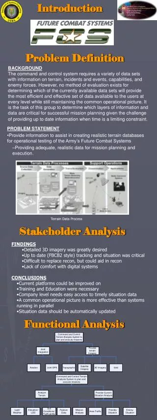
Introduction Problem Definition BACKGROUND The command and control system requires a variety of data sets with information on terrain, incidents and events, capabilities, and enemy forces. However, no method of evaluation exists for determining which of the currently available data sets will provide the most efficient and effective set of data available to the users at every level while still maintaining the common operational picture. It is the task of this group to determine which layers of information and data are critical for successful mission planning given the challenge of providing up to date information when time is a limiting constraint. • PROBLEM STATEMENT • Provide information to assist in creating realistic terrain databases for operational testing of the Army’s Future Combat Systems • Providing adequate, realistic data for mission planning and execution. Terrain Data Process Stakeholder Analysis • FINDINGS • Detailed 3D imagery was greatly desired • Up to date (FBCB2 style) tracking and situation was critical • Difficult to replace recon, but could aid in recon • Lack of comfort with digital systems • CONCLUSIONS • Current platforms could be improved on • Training and Education were necessary • Company level needs easy access to timely situation data • A common operational picture is more effective than systems running in parallel • Situation data should be automatically updated Functional Analysis
Capstone Team Left to right: Mike Chun, Guillermo Guandique, Chris Grevious, Gene Page Cadet Michael Chun Operations Research (845) 515-3646 Michael.Chun@usma.edu Cadet Christopher Grevious Engineering Management (845) 515-5379 Christopher.Grevious@usma.edu Cadet Guillermo Guandique Systems Engineering (845) 515-1008 Guillermo.Guandique@usma.edu LTC Rob Kewley Advisor (845) 938-5206, Fax: (845) 938-5919 Robert.Kewley@usma.edu Cadet Eugene Page Engineering Management (845) 515-4555 Eugene.Page@usma.edu Value Modeling Command and Control Experiment MISSION 1st Platoon, Alpha Company, TF 1-1 will depart from FOB Eagle at VQ81513789 and conduct raid operations at OBJ Raptor (VQ88554139) NLT 0900 02APR2007 to support stability operations. Known enemy activity along major built up MSR’s. Area of operations at OBJ Raptor known to be very hostile. Bradley Platoon Organization Objective Raptor Maneuver Control System Interface
Experiment Execution Concept Sketch on OBJ Raptor at Detail Level 1 Concept Sketch on OBJ Raptor at Detail Level 2 Concept Sketch on OBJ Raptor at Detail Level 3 MAJ Gardner explains scheme of maneuver at Level 3 Results Mission Planning Effectiveness increases drastically then levels off with extremely, beyond useful, detailed data Detail Level 2 effectiveness breakdown by feature Detail Level 3 effectiveness breakdown by feature The Value of Data by Exercise Level of Detail Conclusions • Need at least 1 meter imagery for effective mission planning • Need at least DTED 2 elevation data to accurately incorporate terrain features into planning • Roads, bridges, and trafficability are critical features • Vegetation can be easily seen on imagery • Photographs taken on the ground facilitate detailed planning • LIDAR data is useful but not critical to mission planning Recommendations Elevation Data- Use DTED 2 elevation data (without LIDAR) in conjunction with Line of Sight tools Aerial Photography- Use Quickbird .6 meter resolution for FCS testing Feature Data- Utilize general feature data ie roads, bridges, water, buildings, vegetation Tactical Situation-Assume limited airspace/no ground control, adjust available data based on progress of operations/terrain build time Acknowledgments LTC Kewley LTC Hendricks Dr. David Lashlee Mr. Joe Harrison CME (poster template)


