TAS MA NI A
Tasmania live in Australia. TAS MA NI A. M A P.

TAS MA NI A
E N D
Presentation Transcript
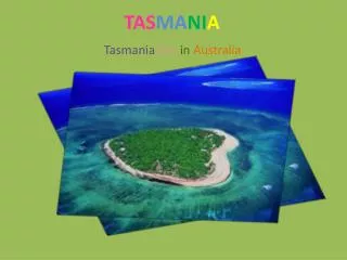
TasmanialiveinAustralia TASMANIA
Island of Tasmania. Is a state of Australia. Located approximately 240 km (150 miles) south of the eastern part of the Australian continent. Being separated by Bass Strait. Tasmania has a population of approximately 456,652 people (as of the 2001 census) and an area of 68,332 km (26,383 square miles) of the survey on 31 March 2003 showed that the population in Tasmania. approximately 476,199 people living real nickname of Tasmania is an island with Apple because Apple is growing. And shape of the island as a result of Apple. Tasmania
HOBART The capital and largest city of the island of Tasmania is Hobart Houma Nation. Community, including Hobart and Claire Lawrence city with a large population, including the city of Launceston in the north and Devonport. Bernie the north west of the island.
Physical history The island is believed to have been joined to the mainland of Australia until the end of the last glacial period approximately 10,000 years ago. Much of the island is composed of Jurassic dolerite intrusions (upwellings of magma)through other rock types, sometimes forming large columnar joints. Tasmania has the world's largest areas of dolerite, with many distinctive mountains and cliffs formed from this rock type. • The central plateau and the southeast portions of the island are mostly dolerite. Mount Wellington above Hobart is a good example, showing distinct columns known as the Organ Pipes. In the southern midlands as far south as Hobart, the dolerite is underlaid by sandstone and similar sedimentary stones. In the southwest, Precambrian quartzites was formed from very ancient sea sediments and form strikingly sharp ridges and ranges, such as Federation Peak or Frenchmans Cap.
In the northeast and east, continental granites can be seen, such as at Freycinet, similar to coastal granites on mainland Australia. In the northwest and west, mineral-rich volcanic rock can be seen at Mount Read near Rosebery, or at Mount Lyell near Queenstown. Also present in the south and northwest is limestone with magnificent caves. The quartzite and dolerite areas in the higher mountains show evidence of glaciation, and much of Australia's glaciated landscape is found on the Central Plateau and the Southwest. Cradle Mountain, another dolerite peak, for example, was a nunatak. The combination of these different rock types offers incredible scenery, much of it distinct from any other region of the world. In the far southwest corner of the state, the geology is almost completely quartzite, which gives the mountains the false impression of having snow-capped peaks year round.
Recent history The state was badly affected by the 1967 Tasmanian fires, in which there was major loss of life and property. In the 1970s, the state government announced plans to flood environmentally significant Lake Pedder. As a result of the eventual flooding of Lake Pedder, the world's first greens party was established; the United Tasmania Group. In 1975, the Tasman Bridge collapsed when the bridge was struck by the bulk ore carrier MV Lake Illawarra. This made crossing the Derwent River at Hobart almost impossible. National and international attention surrounded the campaign against the Franklin Dam in the early 1980s. On 28 April 1996, in the incident now known as the Port Arthur massacre, lone gunman Martin Bryant shot and killed 35 people (including tourists and residents) and injured 21 others. The use of firearms was immediately reviewed, and new gun ownership laws were adopted nationwide, with Tasmania's law one of the strictest in Australia. In April 2006, the Beaconsfield Mine collapse was triggered by a small earthquake. One person was killed and two others were trapped underground for 14 days.
Tasmanian devil A rare animal found only on this Tasmania is land. Including Tasmanian devil.
The flag consists of a defaced British Blue Ensign with the state badge located in the fly. The badge is a white disk with a red lion passant in the centre of the disk. There is no official record of how the lion came to be included on the flag. Where this design originated from is unknown, but it is assumed that the red lion is a link with England. This flag has remained almost unchanged since 1875, with only a slight change of the style of the lion when the flag was officially adopted by the government in 1975, although this was a mistake, as it had already been officially gazetted by the colonial government in 1876.
Armorial Ensigns for the said State of Tasmania that is to say - Quarterly Gules and barry wavy Argent and Azure a Fesse of the second charged with a Ram statant proper between in chief a Garb and a Thunderbolt and in base four Apples and a Branch of Hops all Or, For the Crest On a Wreath Argent and Gules: A Lion statant Gules resting the dexter fore paw on a Spade and a Pick - axe in saltire proper And for Supporters, on either side A Tasmanian Tiger proper, with the motto “Ubertas et Fidelitas” as the same are in the painting hereunto annexed more plainly – depicted to be borne for the said State of Tasmania upon Seals Shields, Banners or otherwise according to the Laws of Arms