Download
1 / 19
190 likes | 265 Vues
ELP High wind event. Tuesday December 8 2009.

E N D
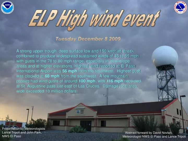
ELP High wind event Tuesday December 8 2009 A strong upper trough, deep surface low and 150 knot jet streak combined to produce widespread sustained winds of 45 to 55 mph with gusts in the 70 to 80 mph range, especially in downslope areas and at higher elevations. Highest wind reported at El Paso International Airport was 56 mph from the southwest. Highest gust was clocked at 68 mph from the southwest. A few mountain passes had wind gusts of around 100 mph, with 116 mph recorded at St. Augustine pass just east of Las Cruces. Damage total area wide exceeded 10 million dollars. Presentation by MeteorologistsLance Tripoli and John Park,NWS El Paso Abstract forward by David Novlan, Meteorologist NWS El Paso and Lance Tripoli
08/1955Z MODIS AQUA METSATImage of southern NM and far west TX Supporting the Nation’s commerce with information for safe, efficient, and environmentally sound transportation.
SPC 250mb analysis loop 07/12Z to 09/12Z Supporting the Nation’s commerce with information for safe, efficient, and environmentally sound transportation.
SPC 500mb analysis loop 07/12Z to 09/12Z Supporting the Nation’s commerce with information for safe, efficient, and environmentally sound transportation.
SPC 700mb analysis loop 07/12Z to 09/12Z Supporting the Nation’s commerce with information for safe, efficient, and environmentally sound transportation.
SPC 850mb analysis loop 07/12Z to 09/12Z Supporting the Nation’s commerce with information for safe, efficient, and environmentally sound transportation.
HPC SW US SFC analysis loop 8/00Z to 9/06Z Supporting the Nation’s commerce with information for safe, efficient, and environmentally sound transportation.
Mountain Wave Model On the morning of December 8th, model forecasts identifieda classic Mountain Wave Signature(MWS) east of the Organ Mountains. EPZ 12-8-09 12Z RAOB 500mb 700mb 12 km NAM “Mountain Wave Signature” Supporting the Nation’s commerce with information for safe, efficient, and environmentally sound transportation.
Dec 8 2009 02Z -16Z apprx.linear descent of high winds KELP ASOS KDMN ASOS
AIRMETS and SIGMETS issued by AWCearly on Dec 8 2009. OCNL SEV TURBC BLW 150DUE TO STG LOW LVLWLY/SWLY WNDS AND CDFNTVALID 08/1010 – 08/1410CONDTS MOVG EWDAND CONTG BYD 1410Z • ELP UUA /OV ELP /TM 1755 /FL170 /TP C560 /SK OVC080-TOP130 /TB MOD-SEV /RM RINAL RWY 22 • ELP UA /OV ELP /TM 1700 /FL100 /TP B737 /TB MOD /RM MOD DURD FL100 TO SURFACE Supporting the Nation’s commerce with information for safe, efficient, and environmentally sound transportation.
Potential Impacts on Flight Operations • TURBULENCE • CROSS-WIND LIMITATIONS • VISIBILITY – BLOWING DUST • WIND SHEAR • FOREIGN OBJECT DAMAGE (F.O.D.) Supporting the Nation’s commerce with information for safe, efficient, and environmentally sound transportation.
WFO El Paso Airport Wind Advisory Lead Time for this advisory was 12 hours 16 minutes Supporting the Nation’s commerce with information for safe, efficient, and environmentally sound transportation.
Impacts on ELP operations • RWY 8L “X” knocked over by wind. • T-Hangar UU7 doors blown off track. • Fabric at seasonal parking fence torn down because of high winds. • AA – inbound/outbound flights, CAL – 2 flights cancelled, SWA – 9 flights cancelled. • Tree knocked over by wind onto parked car • Escort Alpha Southwest off property, work stopped due to high winds. • Truck lost bed cover due to high winds • Continuous F.O.D. surveillance due to high winds • West patio locked due to high winds Supporting the Nation’s commerce with information for safe, efficient, and environmentally sound transportation. Use ELP photo here
Photo courtesy of Greg Lundeen Impacts around the area • 116 mph gust measured at San Augustin Pass • 97 mph gust measured 3 miles ESE of Organ, NM • Widespread damage reported across northeast El Paso. Roofs partially blown off…trees and branches blown down. Car windows broken by blowing debris. • Trans Mountain road closed due to winds and small rocks blowing. • 79 mph gust measured at Chapin HS in NE El Paso. • Awning/false store front collapsed from building on Burro Street. Reports of trees and power lines down. Homes damaged throughout Cloudcroft area. • Roof damage at WSMR police station. • 83 mph gust measured at White Sands Space Harbor. Photo courtesy of John Fausett Supporting the Nation’s commerce with information for safe, efficient, and environmentally sound transportation.
KELP ARRIVAL/DEPARTURE WIND CONSIDERATIONS Supporting the Nation’s commerce with information for safe, efficient, and environmentally sound transportation.
Supporting the Nation’s commerce with information for safe, efficient, and environmentally sound transportation.
KEPZ - Windy city south WIND EVENT STATISTICS JAN 1996 – MAR 2010 • 47 HIGH WIND EVENTS TOTAL • 28TSTM– PEAK GUST 66KTS • 19– PEAK GUST KTS • MAX WIND SINCE 1950 – KTS(MAR 10 1977 and MAR 26 2010) GRADIENT 73 (84 mph) 73 • ≥30KTS…..AVERAGE 128 DAYS/YR • ≥30KTS…..20 DAYS NOV – JAN • ≥30KTS…..42 DAYS FEB – APR • OUR LONGEST CONTINUOUS PERIODWITH PEAK WINDS ≥30KTS LASTED 8 DAYS Supporting the Nation’s commerce with information for safe, efficient, and environmentally sound transportation.
Our aviation program includes.. • Terminal Aerodrome Forecasts (TAFs)are produced 4 times daily • at: 6 am MDT(5 am MST)and12 pm MDT(11 am MST) 6 pm MDT(5 pm MDT)and12 am MDT( 11 pm MST) • for 4 airports in our County Warning Forecast Area (CWFA) including: • El Paso International Airport (ELP) • Deming Regional Airport (DMN) • Truth Or Consequences Regional Airport (TCS) • Las Cruces International Airport (LRU) • WFO EPZ Airport Wind Advisories:Issued when we expect either of the following criteria are expected to persist for1hour or more: • Sustained Winds 20 kts(23 mph) AND gust spread of at least 10 kts(11 mph) • Sustained Winds 30 kts(34 mph) or greater • Aviation Forecast Discussions : Routinely produced twice daily, and updated as needed for changing weather. Discussions address Lowand High pressuresystems, fronts, thunderstorms and their expected impacts on winds, ceilings and visibilities across southwest New Mexico and far west Texas. • When time allows, we like to give ELP ATCT a courtesy ‘heads up’ call for weather expected to impact the airport within the next 2 hrs. Supporting the Nation’s commerce with information for safe, efficient, and environmentally sound transportation.
Questions? Just ask the weatherman Thank you allfor your time today! Supporting the Nation’s commerce with information for safe, efficient, and environmentally sound transportation.