Geodatabase Creation and Features Management in ArcGIS
Learn the step-by-step process to create a geodatabase, feature dataset, and feature class in ArcGIS. Also, discover how to export feature classes to shapefiles for effective data management.

Geodatabase Creation and Features Management in ArcGIS
E N D
Presentation Transcript
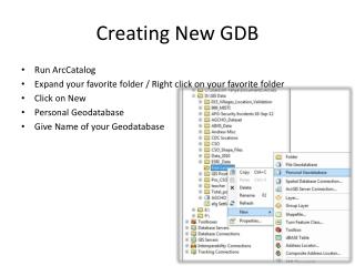
Creating New GDB • Run ArcCatalog • Expand your favorite folder / Right click on your favorite folder • Click on New • Personal Geodatabase • Give Name of your Geodatabase
Creating Feature Dataset • Run ArcCatalog • Expand your favorite GDB • Right click • Click on New • Click Feature Dataset
Creating Feature Dataset • Define the Name of your New Feature Dataset • Define/Choose the coordinate system for your New Feature Dataset • Expand Geographic Coordinate System • Expand World Folder • Click on WGS 1984 • Click Next • Click Finish
Creating Feature Class • Expand/Click on your Favorite GDB • Right Click – Click on New • Click on New Feature Class • Define name of your new feature class and Alias • Define type of your new feature class : Polygon Feature, Line Feature, Point Feature, MultiPoint Feature
Creating Feature Class • Click on next • Define the coordinate system for your feature class • Expand Geographic Coordinate System • Expand World folder • Click next • Click next • Click Finish
Creating GDB Using ArcToolbox • Run ArcMap • Click on ArcToolbox • Expand Data Management Tool • Expand Workspace • Click on Create Personal GDB
Creating GDB Using ArcToolbox • Define your GDB location “ Personal GDB Location” • Define your GDB Name “ Personal GDB Name” • Define your GDB version “Personal GDB Version “ • Click Ok
Exporting Feature Class to Shape File • Run ArcCatalog • Expand your favorite GDB • Right click on feature class that you want to export • Click on Export • Two type of export is available: Multiply, Signal • Click on To Shape File (Signal)
Exporting Feature Class to Shape File • Define Output Location • Define Output Feature Class Name • Define Expression (Optional) (Select filed according our expression to be export) • Click on Ok