Download
1 / 10
110 likes | 315 Vues
NASA Ocean Satellite Missions. Eric J. Lindstrom April 2008. OUTLINE. NASA operating missions (13, 6 ocean) NASA missions in implementation and formulation to launch 2008-2015 (9, 4 ocean) NASA missions beyond 2015 (11, 5 ocean) Merging of scientific disciplines in PO and hydrology in SWOT

E N D
NASA Ocean Satellite Missions Eric J. Lindstrom April 2008
OUTLINE NASA operating missions (13, 6 ocean) NASA missions in implementation and formulation to launch 2008-2015 (9, 4 ocean) NASA missions beyond 2015 (11, 5 ocean) Merging of scientific disciplines in PO and hydrology in SWOT Ocean Surface Topography Constellation Funding the development of high resolution physical oceanography and hydrology (“pre-SWOT research”) in the coming years.
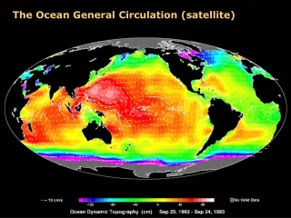
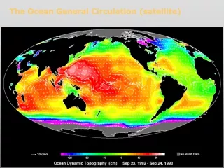
NASA Ocean Missions SeaWiFS SSM/I SARs (variety) AVHRR Metop (OVSW) Color (MERIS)
Missions in Development (launch by 2015) GLORY 2/2009 NPP 9/2009 OCO 12/2008 OSTM 6/2008 AQUARIUS 5/2010 LDCM 7/2011 ICESAT-2 2015 GPM 6/2013, 6/2014 SMAP 2012
NASA Far-Term Missions (6/15 total) *Cloud-independent, high temporal resolution, lower accuracy SST to complement, not replace, global operational high-accuracy SST measurement
Decadal Survey missions individually and as “tier” groups pull together Scientific disciplines and community groups in new and challenging ways. We are embracing this as a step forward in the development of Earth System Science and the maturation of the Earth Observing System at NASA. SWOT is leading the “Tier 2” missions in implementation and we shouldtake care to serve as a model of how to serve two previously-separatedscientific disciplines (physical oceanography and land surface hydrology).
10 11 12 13 14 15 16 17 18 19 20 08 22 09 GFOUS HY-2AChina HY-2B, -2C, -2D Saral/AltiKaIndia/France ERS-2 ESA ENVISAT ESA Sentinel-3A Europe Sentinel-3B, -3C, -3D CRYOSAT-2 ESA SWOT/WaTER-HMUSA/Europe Jason-CS successor Europe/USA Jason-2 Europe/USA Jason-CS/Jason-4 Europe/USA In orbit Needed Approved Planned/Pending approval Ocean Surface Topography Constellation Roadmap 21 Medium accuracy SSH from high-inclination sun-synchronous orbit Swath altimetry from high-inclination orbit (several orbit options) Orbit to be assessed High accuracy SSH from mid-inclination orbit Jason-3 Europe/USA Jason-1 Fr./USA
SWOT FY08 Activities • Water Storage Study (OSU) • Conduct a study to assess the measurement requirements for determining global fresh water storage and storage change. Global water storage and storage change are two of the main science questions for the SWOT hydrology goals, but their implications in terms of instrument measurement requirements have not been fully addressed in past studies. • Submesocale Workshop/Report • Conduct a workshop to address the capabilities of the SWOT mission to measure ocean mesoscale and sub-mesoscale phenomena. Unlike the ocean basin-scale measurement requirements, which have been studied for past altimeter missions, the ocean mesoscale and sub-mesoscale measurement requirements for SWOT are not fully understood. Characterizing the ocean mesoscale and sub-mesoscale, where most of the ocean kinetic energy generation and dissipation takes place, is one of the primary science goals of the SWOT mission. • Orbit Study • Conduct a study to determine a family of orbits that will be used during the SWOT mission. The SWOT orbit determines the design and performance of the instrument payload. Although some orbit definition activities have been conducted in the past, they are insufficient at this time for mission design. The orbits will be designed to providing full coverage of the SWOT regions of interest, minimizing tidal aliasing and orbit error, and optimizing the temporal and spatial sampling of the phenomena to be studied by SWOT. • Instrument Design/Simulator • Determine implementation options for the SWOT instrument. Determine system performance for ocean and land data and produce a detailed error budget for the mission scenarios defined by the science team. Build an instrument and mission simulator capable of generating simulated science data for science team evaluation and to conduct the studies defined below. Identify key technology drivers and a risk reduction plan for future year activities. • Wet Troposphere Study • Examine the impact of wet tropospheric errors across the swath, in coastal regions, and over land. The wet troposphere delay constitutes one of the main unknowns in the SWOT error budget, especially in coastal regions and over land. This task will utilize high-resolution regional weather models, measurements, and the instrument simulator defined in task 5 to determine the wet tropospheric component to the SWOT error budget. • Calibration Study • Conduct studies to determine calibration schemes for correcting roll and systematic phase errors in the SWOT data. Roll and systematic phase errors cannot be calibrated by the instruments directly, but must rely on calibration using the payload data and post-processing. These are the dominant contributors to the SWOT error budget if uncalibrated. The calibration schemes to be studied will use ascending/descending cross-overs of the nadir altimeter and the interferometer over the ocean. Over land, calibration using available digital elevation models will be used. The effectiveness of the calibration schemes depends on the orbit selected and the effects of the wet tropospheric delays, studied above. • Simulated Science Products • Generate simulated science data sets to be studied by the SWG to assess different mission scenarios and the science impacts of the SWOT mission. • Management/Reports • Prepare a Level-1 science requirement document. • Prepare a follow-on task plan, if requested. • Prepare a final report • Spacecraft Study • Derive the spacecraft requirements for the SWOT mission and prepare a Request for Information (RFI) to spacecraft vendors to assess the cost and feasibility of the SWOT mission on existing, modified, or planned US spacecraft buses. Provide an assessment of the CNES spacecraft study results. Serve as a point of contact between NASA and CNES regarding spacecraft technical issues.
Funding Future Research NASA is funding SWOT studies for $525K in FY08 and projected $2M inFY09.Beginning in 2009 I hope to be able to fund a small number of proposalsfocused on high resolution ocean surface topography. (~$400K/yr) These will supplement the Ocean Surface Topography Science Team. We should also begin to examine how we can draw forward operational partners or specific applications. NASA has designated an Applications Program Scientist for the Tier 2 missions (John Haynes) and I serve as co-lead of a NASA-NOAA team trying to accelerate the transition of satellite measurement capabilities from NASA to NOAA.