Water Science Research in Northern Shenandoah Valley
50 likes | 70 Vues
Explore USGS research goals and activities in the Great Valley region focusing on water availability, quality assessment, geologic controls, and stream/aquifer interactions.

Water Science Research in Northern Shenandoah Valley
E N D
Presentation Transcript
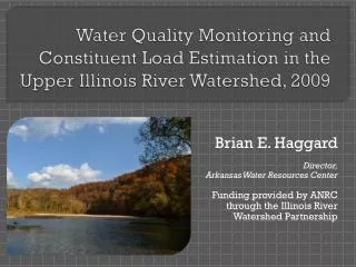
USGS West Virginia Water Science Center Research Goals, Activities, and Recommendations for theNorthern Shenandoah Valley Region Hugh E. Bevans Center Director
Great Valley Water Resources Science Forum • Formed in January 2003 by USGS and partners to enhance the integration of USGS science programs for addressing the availability, vulnerability, and quality of ground water in the Great Valley • Includes representatives of USGS, universities, state and local agencies, and public interest groups from Pennsylvania, Maryland, Virginia, and West Virginia. • Will focus initial efforts in the Northern Shenandoah Valley of Virginia and West Virginia, and contiguous areas of Maryland and Pennsylvania. • http://va.water.usgs.gov/GreatValley/Index.htm
West Virginia Water Science Center Research Goals • Since 1990, USGS has published 10 reports on ground water in the Great Valley of WV • Goal is to investigate the availability of water for human needs and aquatic ecology • To collect hydrologic information for assessing the availability and quality of water, identifying trends, and evaluating natural and human impacts • To understand geologic controls on the occurrence, movement, and availability of ground water • To identify stream/aquifer interactions • To understand relations among land use, point sources, and water quality • To develop and apply ground-water models for quantifying water availability and predicting natural and human impacts
West Virginia Water Science CenterRecent Research • Berkeley and Jefferson County • Fracture-trace and aquifer pump tests • Stream/aquifer interaction (base-flow discharge surveys) • Streamgages (4) • Fecal waste source tracking • Opequon Creek Ground-Water Model • Water Budgets (planning for natural and human impacts) • Flow paths • Stream/aquifer interaction • Leetown Science Center Hydrogeology • Geologic controls on ground water • Geophysical methods • Aquifer hydraulic properties • Ground-water model • Water quality
West Virginia Water Science Center Data Gaps and Research Needs • Data gaps • Networks for determining status, trends, and natural and human impacts • Land use, water use, and population growth; point and non-point sources • Detailed geologic mapping (structure) • Aquifer hydraulic properties • Hydraulic conductivities • Ground-water age dating • Flow rates • Depth of circulation • Remote sensing tools • LiDAR and high-resolution digital elevation models • Surface Geophysics • Stream/aquifer interaction • Base-streamflow surveys • Chloride balances • In-stream flow and quality requirements for aquatic ecosystems • Impacts of point and non-point sources on water quality • Ground-water models • Steady State • Transient (storage)