
Uploaded by
genna
22 SLIDES
615 VUES
260LIKES
Surface Topography
DESCRIPTION
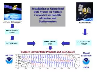
Establishing an Operational Data System for Surface Currents from Satellite Altimeters and Scatterometers. Jason. Topex/ Poseidon. QuikScat. Surface Topography. Vector Winds. NOAA NESDIS OSDPD. NOAA NESDIS ORA. NOAA NESDIS OSDPD. NAVOCEANO.
Download
1 / 22
Download Presentation

Télécharger la présentation
Surface Topography
An Image/Link below is provided (as is) to download presentation
Download Policy: Content on the Website is provided to you AS IS for your information and personal use and may not be sold / licensed / shared on other websites without getting consent from its author.
Content is provided to you AS IS for your information and personal use only.
Download presentation by click this link.
While downloading, if for some reason you are not able to download a presentation, the publisher may have deleted the file from their server.
During download, if you can't get a presentation, the file might be deleted by the publisher.
E N D
Presentation Transcript
Establishing an Operational Data System for Surface Currents from Satellite Altimeters andScatterometers Jason Topex/ Poseidon QuikScat Surface Topography Vector Winds NOAA NESDIS OSDPD NOAA NESDIS ORA NOAA NESDIS OSDPD NAVOCEANO Surface Current Data Products and User Access Hawaii Coastwatch NESDIS PMEL
Total surface current velocity superimposed on sea surface temperature
NOAA IGDC DATA FLOW NAVY IGDR IMPROVE CORR. TAI ORBIT ADJ, ADJUST AGAINST PREVIOUS NGDC CYCLE NGDC NIGDC


More Related
Audio
Live Player