Download
1 / 1
10 likes | 107 Vues
CONTRIBUTIONS TO INTEGRATIVE KNOWLEDGE OF WEST NILE VIRUS REPORTED IN ROMANIA - METHODS AND TOOLS FOR MANAGING HEALTH-ENVIRONMENT RELATIONSHIP AT DIFFERENT SPATIAL AND TEMPORAL SCALES

E N D
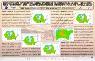
CONTRIBUTIONS TO INTEGRATIVE KNOWLEDGE OF WEST NILE VIRUS REPORTED IN ROMANIA - METHODS AND TOOLS FOR MANAGING HEALTH-ENVIRONMENT RELATIONSHIP AT DIFFERENT SPATIAL AND TEMPORAL SCALES LilianaBaltesiu(liliana.baltesiu@rosa.ro), Marian TraianGomoiu(mtgomoiu@gmail.com), RaduMudura(radu.mudura@rosa.ro), Gabriela Nicolescu(gabrielamarianicolescu@yahoo.co.uk), Valeria Purcarea-Ciulacu(valeria_purcareaciulacu@yahoo.com) Background of researchAfter 1990 there were environmental changes at national, European and global level which led to the emergence and re-emergence of infectious diseases. Among these diseases, those transmitted by vectors were installed on very large areas where pathogens entered the complex transmission cycles within the local ecosystems. Environmental changes were generated by climatic (temperature and precipitation), geomorphologic (altitude) and anthropogenic (land cover /land use) changes. Due to these environmental changes it became necessary to anticipate, prevent and control the epidemics in order to avoid major crises of natural and socio-economic systems. In these circumstances, the risk of re-emergence of West Nile virus infection increased, thus becoming a public health problem for Romania. Our research consisted in assessing this risk, depending on environmental changes that can influence the presence and space-time distribution as well as the dynamics of the elements of virus transmission cycle.Study areas were selected so that they should meet, on the one hand, very different natural ecosystems and on the other hand should include continuously changing anthropogenic ecosystems that provide optimal conditions for the vector-borne West Nile virus. These areas were: the Danube Delta including Razim-Sinoe complex (Tulcea County), Bucharest Metropolitan Area (BMA) (Bucharest and Ilfov & Giurgiu Counties). Methods Maps were made using ArcGis - ArcMap software, depending on the mean annual temperature and precipitation. We were used by the altitude risk map the hypsographic map of Romania and for the risk map by land cover/land use, information provided by the Land Cover/Land Use Classification System for Romania (2003) data. The four types of risk maps (depending on temperature, precipitation, altitude and cover / land use) were overlaid, thus achieving the final risk maps. ConclusionGiven that in the year 2009 and 2010, from April to August there were increases in air temperature and precipitation thus creating favourable conditions for mosquitoes vector population growth. All risk and distribution maps for West Nile virus (WNV)for 2009-2011 presented in the two study areas (Bucharest Metropolitan Area-BMA andTulcea County) from vectors (mosquitoes), the main hosts(wild and domestic birds) and the tangential hosts(horses) were required to identify human casesthat presented neurological infection with this virus. Note increased numbers of human cases those presenting neurological infection with WNV in 2010 almost across the country. From the risk maps obtained we observed intense circulation of West Nile virus (WNV) in Romania thus occurrence of human infection outbreak or epidemic. ResultsFor the period 2009 - 2011 the authors developed risk maps to West Nile virus vectors to vertebrate hosts depending on climatic, geomorphologic and anthropogenic changes. The four types of risk maps (depending on temperature, precipitation, altitude and cover/land use) were overlaid, thus achieving the final risk maps. Also, space-time distribution maps were made at national and regional level for vertebrate hosts and vectors. European Geosciences Union – General Assembly 2012, Vienna, Austria, 22 – 27 April 2012 On the basis of the information forecasts are developed concerning the occurrence of these diseases in different types of ecosystems, as well as early warnings and strategies at national and European level in order to protect the human population.