“ OLYMPEX ”
This proposal introduces the "OLYMPEX" field experiment, which aims to validate and improve the accuracy of precipitation estimation algorithms for hydrological applications. The experiment will focus on physical validation, rain and snow measurement, and testing the efficacy of GPM to improve streamflow forecast. Key questions to be addressed include the handling of rain-snow transitions on sloping terrain, the impact of the melting layer on algorithm performance, and the accuracy of satellite rain measurements in relation to topography.

“ OLYMPEX ”
E N D
Presentation Transcript
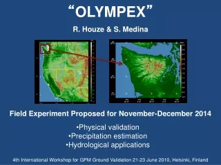
R. Houze & S. Medina “OLYMPEX” Field Experiment Proposed for November-December 2014 • Physical validation • Precipitation estimation • Hydrological applications 4th International Workshop for GPM Ground Validation 21-23 June 2010, Helsinki, Finland
The Olympic Peninsula is a natural “precipitation laboratory” • Persistent southwesterly flow during the winter provides a reliable source of moisture • Extremely large precipitation accumulation produced as the moist SWly flow impinges on coastal terrain • Low 0ºC level rain at low elevations, snow at higher levels
The Olympic Peninsula is a natural “precipitation laboratory” • Persistent southwesterly flow during the winter provides a reliable source of moisture NCEP long-term mean sea level pressure (mb) for winter (December to January) and topography
Maximum The Olympic Peninsula is a natural “precipitation laboratory” • Extremely large precipitation accumulation produced as the moist SWly flow impinges on coastal terrain Annual average precipitation (PRISM)
Frequency of occurrence 0°C level The Olympic Peninsula is a natural “precipitation laboratory” • Low 0ºC level rain at low elevations, snow at higher ones Distribution of Nov-Jan 0°C level for flow that is onshore and moist at low levels (KUIL sounding)Mean 0°C level during storms = 1.5 kmSee this full range in individual storms! Plot provided by Justin Minder
Resources and experience in the region • 1965-2000: Cascade Project, CYCLES, COAST • 2001: IMPROVE field experiment • 2004-2008: Detailed observing network across a southwestern Olympics ridge • 2009: NOAA Mobile Atmospheric River Monitoring System in Westport • 2011/12: NWS Coastal radar expected to be in place • Ongoing: Regional Environmental Prediction
Resources and experience in the region • 2001: IMPROVE-1 field experiment (Stoelinga et al. 2003) Coastline
Resources and experience in the region 2001: IMPROVE-2 field experiment (Stoelinga et al. 2003) Woods et al. 2005
Detailed gauge network SNOTEL RAWS sites COOP site Anemometers Disdrometers Resources and experience in the region • 2004-2008: Detailed observing network across a southwestern Olympics ridge (Minder et al. 2008)
Resources and experience in the region • 2009: NOAA Mobile Atmospheric River Monitoring System in Westport Data from vertically-pointing S-band radar Signal-to- noise ratio Height Radial velocity Height Time
Resources and experience in the region • 2011/12: NWS Coastal radar expected to be in place Example of Olympic Mountain slopes views from coastal radar Dark gray areas indicate regions where the 0.5° elevation scans are blocked Current radar coverage Radar coverage with coastal radar
Resources and experience in the region • Ongoing: Regional Environmental Prediction-- WRF, hydrology, air quality, etc (Mass et al. 2003) Real-time mesoscale numerical simulations dx = 36 km dx = 4 km
Resources and experience in the region • Ongoing: Regional Environmental Prediction-- WRF, hydrology, air quality, etc (Mass et al. 2003) • Runs in ensemblemode 1.33 km spatial resolution coming soon
Resources and experience in the region • Ongoing: Regional Environmental Prediction-- WRF, hydrology, air quality, etc (Mass et al. 2003) Long period of continuous mesoscale simulations provides model climatology e.g., 5-yr MM5 Nov-Jan precipitation climatology (mm) Verified by gauges: Minder et al. 2008
Resources and experience in the region • Ongoing: Regional Environmental Prediction-- WRF, hydrology, air quality, etc (Mass et al. 2003) Ensemble forecasting probabilistic information e.g., probability that the precipitation accumulated in a 3 h period > 0.1in
Resources and experience in the region • Ongoing: Regional Environmental Prediction-- WRF, hydrology, air quality, etc (Mass et al. 2003) Hydrological prediction: Mesoscale numerical output drives a distributed hydrological model basin streamflow forecast
GPM components that are feasible to address in the Olympic Peninsula • Physical validation of algorithms • Rain and snow measurement • Hydrological applications
Physical validation (i.e. experimentation with physical assumptions in GPM algorithms) • How well do retrieval algorithms handle transitions from rain to snow on sloping terrain? • How does the melting layer affect algorithm performance? • How do algorithms perform in different sectors of storms passing over mountains and in different types of precipitation?
Precipitation estimation (i.e. validation of its accuracy from satellite instruments mounted on aircraft) • Do precipitation algorithms give realistic rainfall transition from ocean to land? • Do precipitation algorithms yield accurate orographic enhancement of rain amounts? • How can satellite rain measurements be downscaled accurately relative to the topography?
Hydrological applications(i.e. testing the efficacy of GPM to improve streamflow forecasting in complex terrain) • Can satellite rain estimates over mountains provide useful input to real-time hydrologic forecasting? • Does downscaling relative to topography improve hydrologic forecasting? • Can assimilation of satellite rain estimates into regional forecasting models improve hydrological forecasts?
Possible field experiment configuration P3 DC8 ER2 GH NPOL would have an unimpeded view of the Quinault valley and the Olympic mountains
Conclusions • The Olympic Peninsula is an ideal natural laboratory • Persistence of moist flow • complex terrain • huge precipitation amounts • low 0°C level • Existing and planned resources plus past experience • provide a strong framework for a field campaign • Crucial NASA & NOAA facilities could be added • NPOL, aircraft, profilers, etc • Can address • Physical validation of GPM algorithms • Rain and snow measurement • Hydrological applications
This research was supported byNSF Grant ATM-0820586 and NASA Grants NNX07AD59G and NNX10AH70G