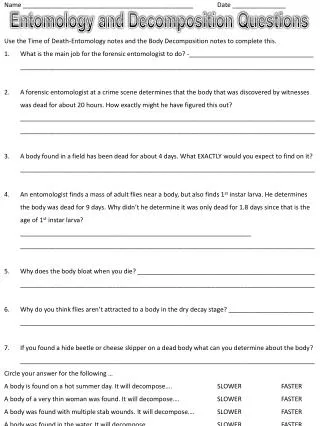
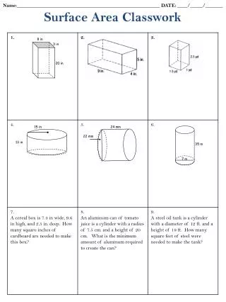
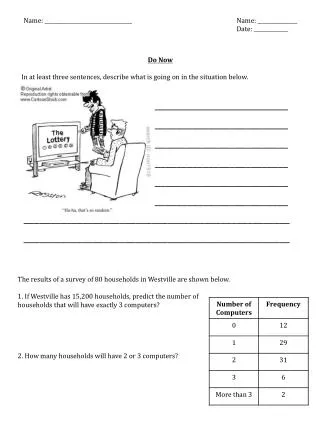
Download

1 / 15
150 likes | 442 Vues
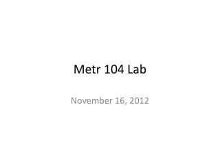
Briefing for Weather Forecast for KOKC (Oklahoma City, OK) on the day, month, and year for which you are forecasting. Your Name METR 104 Today ’ s date. 0. Overview of Current Weather Conditions. visible and infrared satellite images a composite surface weather map

E N D
Briefing for Weather Forecast for KOKC(Oklahoma City, OK)on the day, month, and yearfor which you are forecasting Your Name METR 104 Today’s date
0. Overview of Current Weather Conditions • visible and infrared satellite images • a composite surface weather map • a composite map of conditions aloft • a jet stream map
Forecast Discussion • For 12Z Temperature: Describe the part of the conceptual model of the daily temperature cycle that provides the basis for the your forecast. • For the effect of cloudiness on 12Z or on 18Z temperature: State the criteria for whether or not clouds will affect the 12Z or 18Z temperature. Then identify the source(s) of the information that you use to make your forecast and the reasoning that you apply, including any assumptions that you make. • For the effect of a front on 12Z or 18Z temperature: State the criteria for whether or not a front will affect the 12Z or 18Z temperature. Then identify the source(s) of the information you used to make your forecast and the reasoning that you apply, including any assumptions that you make. • For the effect of temperature advection on 12Z or 18Z temperature: State the criteria for whether or not temperature advection will affect the 12Z or 18Z temperature. Then identify the source(s) of the information you used to make your forecast, together with the reasoning that you apply, including any assumptions that you make. • For your particular forecasting question, consult the Forecasting Tactics document for details. • Your discussion should be detailed enough so that someone else could reproduce your forecast. • If necessary, use more than one PowerPoint slide for your discussion.
Forecast Discussion (cont’d) • For 18Z temperature: Describe the conceptual model that provides the basis for the your forecast. (Use the annotated temperature plot on the next slide.) Then identify the source(s) of the information you used to make your forecast and the reasoning that you apply, including any assumptions that you make. • For 18Z wind speed or wind direction: Identify the sources of information that you use for making your forecast, together with the analysis and reasoning that you use. In particular, comment on the relative strengths and weaknesses of the NWS point forecast and the NAM forecast, and comment on how you factor them into your forecast. • For whether or not there will be precipitation in the 24 hours starting at 12Z tomorrow: Identify your source(s) of information and explain the analysis and reasoning that you use to make your forecast. • For your particular forecasting question, consult the Forecasting Tactics document for details. • Your discussion should be detailed enough so that someone else could reproduce your forecast. • If necessary, use more than one PowerPoint slide for your discussion.
1. 12Z Temperature Links: • Latest available meteogram(Drag and drop a copy of the meteogram here, and rescale it to a smaller size.) • Next-latest available meteogram(Drag and drop a copy of the meteogram here, below the link [putting both on a new page if necessary], and rescale it to a smaller size) • Latest NWS Point Forecast: Copy and paste text from the NWS point forecast relevant to 12Z tomorrow. For example: Tonight: A 20 percent chance of showers. Mostly cloudy, with a low around 57. South southeast wind around 6 mph. • Latest computer model (NAM) forecast of winds and temperaturesat 12Z tomorrow(Drag and drop a copy of the NAM forecast map here, below the link [putting both on a new page if necessary], and rescale the map to a smaller size.)
2. Will cloudiness affectthe 12Z temperature tomorrow? Links: • Latest NWS Point Forecast: Copy and paste text from the NWS point forecast relevant to 12Z tomorrow. For example: Tonight: A 20 percent chance of showers. Mostly cloudy, with a low around 57. South southeast wind around 6 mph. • wunderWiki: “Educational: Partly Cloudy” (an attempt to interpret the language used in NWS cloudiness forecasts) (Copy and paste relevant text from the wunderWiki Web site here.)
3. Will a front affectthe 12Z temperature tomorrow? Links: • Verification area for fronts affecting KOKC • NWS Hydrometeorological Prediction CenterShort Range Forecasts(Drag and drop copies of the relevant “short range forecast” maps here, rescaling them to a smaller size. Label each with the forecast time).
4. 18Z Temperature Links: • Latest available meteogram(Drag and drop a copy of the meteogram here, rescaling it to a smaller size.) • Next-latest available meteogram(Drag and drop a copy of the meteogram here, below the link [putting both on a new page if necessary], and rescale it to a smaller size.) • Latest NWS Point Forecast: Copy and paste text from the NWS point forecast relevant to tomorrow’s 18Z temperature forecast. For example: Tonight: A 20 percent chance of showers. Mostly cloudy, with a low around 57. South southeast wind around 6 mph. Friday: A 60 percent chance of showers. Cloudy, with a high around 66. Southwest winds from 10 to 15 mph. • Latest computer model (NAM) forecastof winds and temperatures at 18Z tomorrow(Drag and drop a copy of the NAM forecast map here, below the link [putting both on a new page if necessary], and rescale the map to a smaller size.)
5. Will cloudiness affectthe 18Z temperature tomorrow? Links: • Latest NWS Point Forecast: Copy and paste text from the NWS point forecast relevant to 18Z tomorrow. For example: Friday: A 60 percent chance of rain. Cloudy, with a high around 66. Southwest winds from 10 to 15 mph. • wunderWiki: “Educational: Partly Cloudy” (an attempt to interpret the language used in NWS cloudiness forecasts) (Copy and paste relevant text from the wunderWiki Web site here.)
6. Will a front affectthe 18Z temperature tomorrow? Links: • Verification area for fronts affecting KOKC • NWS Hydrometeorological Prediction CenterShort Range Forecasts(Drag and drop copies of the relevant “short range forecast” maps here, and rescale them to a smaller size. Label each with the forecast time).
7. What will the wind speed beat 18Z tomorrow? Links: • Latest NWS Point Forecast: Copy and paste text from the NWS point forecast relevant to 18Z tomorrow. For example: Friday: A 60 percent chance of rain. Cloudy, with a high around 66. Southwest winds from 10 to 15 mph. • Latest computer model (NAM) forecast of winds andtemperatures at 18Z tomorrow (southern Plains region) • Latest computer model (NAM) forecast of winds and temperaturesat 18Z tomorrow (central Oklahoma region)(Drag and drop a copy of the NAM forecast map here, below the link, and rescale the map to a smaller size.)
8. What will the wind direction beat 18Z tomorrow? Links: • Latest NWS Point Forecast: Copy and paste text from the NWS point forecast relevant to 18Z tomorrow. For example: Tonight: A 20 percent chance of showers. Mostly cloudy, with a low around 57. South southeast wind around 6 mph. • Latest computer model (NAM) forecast of winds andsea-level pressures at 18Z tomorrow (southern Plains region) • Latest computer model (NAM) forecast of winds and temperatures at 18Z tomorrow (central Oklahoma region)(Drag and drop a copy of the NAM forecast map here, below the link, and rescale the map to a smaller size.)
9. Will there be precipitation between 12Z tomorrow and 12Z the next day? Links: • NWS Hydrometeorological Prediction CenterShort Range Forecasts(Drag and drop copies of the relevant “short range forecast” maps here, and rescale them to a smaller size. Label each with the forecast time). • Latest NWS Point Forecast: Copy and paste text from the NWS point forecast relevant to the forecast period. (See example below.) Put both the text and the link above on a new page if necessary. Tonight: A 20 percent chance of showers. Mostly cloudy, with a low around 57. South southeast wind around 6 mph. Friday: A 20 percent chance of showers. Cloudy, with a high near 65. Southeast wind 6 to 8 mph becoming southwest. ] Friday Night: A 30 percent chance of rain, mainly after 11pm. Mostly cloudy, with a low around 57. West southwest wind 6 to 11 mph becoming south southeast.
Forecast:Write your forecast here just as you would enter it at the Iowa St. University Web site. Forecast Verification: • Archived meteograms • Archived weather maps for the Great Plains, including fronts • Archived analyses of temperature and wind observations [Compare the appropriate observation(s) with your forecast. How would ISU score it?]