Download
1 / 4
40 likes | 59 Vues
This workshop session will discuss the issues related to hazard data management, including definitions of hazards, institutional aspects, cooperation among technical agencies, development of integrated hazard databases, cooperation with other agencies, latest hazard analysis techniques, and implications of climate change. The session will also cover service delivery models and the importance of national-to-local coordination and partnerships in risk analysis.

E N D
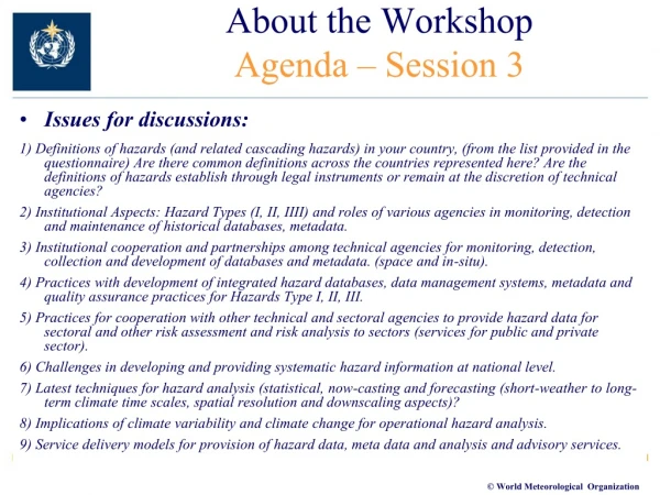
About the WorkshopAgenda – Session 3 • Issues for discussions: 1) Definitions of hazards (and related cascading hazards) in your country, (from the list provided in the questionnaire) Are there common definitions across the countries represented here? Are the definitions of hazards establish through legal instruments or remain at the discretion of technical agencies? 2) Institutional Aspects: Hazard Types (I, II, IIII) and roles of various agencies in monitoring, detection and maintenance of historical databases, metadata. 3) Institutional cooperation and partnerships among technical agencies for monitoring, detection, collection and development of databases and metadata. (space and in-situ). 4) Practices with development of integrated hazard databases, data management systems, metadata and quality assurance practices for Hazards Type I, II, III. 5) Practices for cooperation with other technical and sectoral agencies to provide hazard data for sectoral and other risk assessment and risk analysis to sectors (services for public and private sector). 6) Challenges in developing and providing systematic hazard information at national level. 7) Latest techniques for hazard analysis (statistical, now-casting and forecasting (short-weather to long-term climate time scales, spatial resolution and downscaling aspects)? 8) Implications of climate variability and climate change for operational hazard analysis. 9) Service delivery models for provision of hazard data, meta data and analysis and advisory services.
Summary of issues discussed • National to local Policy, legislation, legal framework and institutional coordination and roles (development, DRR, climate adaptation) • Centralized • Decentralized governments • Driver for the institutional partnership of natural hazard ptrogrammes (government leadership, occurances of major events) • National to local and sectoral institutional roles and mandates for risk analysis, risk reduction, risk transfer (highly varied stake holder community for development and utilization of risk information) • Partnerships and operational working arrangements • Human population, economic development, infrastructure, timing (vacation, rush hour) drivers of risk/impact based information • Need for definitions: • Hazard, exposure, vulnerability, impact, resilience and risk definitions • Hazard Definitions and categorization highly varied (no national categorization to driven by national, regional and international standards) • Role and operational cooperation of technical agencies with respect to • monitoring, detection, database, metadata, hazard analysis and mapping (structure, cooperation, operation, exchange and sharing, interoperability of the systems) • Hazard/risk analysis and modelling (multi-hazard, independent hazards versus cascading) • Interoperability of hazard monitoring, data bases and data management systems (national to local across different agencies) • Hazard data sharing (intra- and inter-) • National Hazard partnerships • Inter-sectoral training on hazard definitions characteristics and inter-linkages • Utilization of and communication of risk information for different decision-making applications (e.g., sectoral applications, crisis management and public) • Level of risk linked to Preparedness measures and response • Long-term planning and investments • Color schemes of hot spots(???) at local levels that need attention
Summary of issues discussed • Need for clarity of definitions what is Hazard, exposure, vulnerability, risk, impact, resilience • Need for definitions on hazard • Different hazard categories, (Meteorological, hydrological, climate etc) • Hazards, cascading secondary, tertiary (TC, wind, sever precipitation and flash flooding, storm surges and coastal flooding, land and mudslides, tornadoes, etc… • Different types in same category (Floods: riverine flood, flash flood, urban flood, glacier out burst flood, etc) (Droughts: meteorological, hydrological, agricultural drought) • Threshold for the hazard definition should be driven by the potential risk (e.g., meteorological and hydrological thresholds versus potential risk based) parameters • National databases (interoperability, data sharing, national-local, formats and ease of development and usability, quality, quantity) • Damage and loss (authoritative versus subjective) • Sectoral/property/infrastructure/Life line sectors such as transportation, health, flood and agriculture • Agency reports, media report (many disadvantages), crowd sourcing, • Intellectual property • Hazard databases • Integration with local data • Interoperability and data sharing of meteorological and hydrological networks operated by various agencies (Public and private networks), voluntary observers (observing station), weather spotters, • Google maps and radar information for (staff of met, spotters and public) • Intellectual property • National risk register (impact/likelihood) • Impact-based decision-support services (need to partner with public and Private sector) • Weather resilient nation (partnership) • Evaluation back and forth of the information and decision value chains (on impact based systems)
Summary of issues discussed(Other issues) • coverage and resolution of data: • Observing network (minimum, versus what is needed to monitor the hazard in high exposure/vulnerable areas) • National/local hazard data versus regional and global databases (role of WMO RCC, RSMCs and Global data centers) • Reanalysis data • Applications of Hazard Mapping and relevance of thresholds • Awareness raising/ evacuation routes and public preparations (Presentation of JMA) • Quantification of risk for sectoral planning, risk financing, risk management • Land zoning and infrastructural construction and building codes (Strict regulations) • Survey of the NMHS capacities and institutional cooperation in 2015 to determine progress made in servicing DRR community