
Inundation Analysis of Hurricanes Ivan, Dennis, and Katrina
Explore water level activity during hurricanes Ivan, Dennis, and Katrina on the Gulf Coast, analyzing peak elevations and duration of inundation using CO-OPS tools. Investigate storm impacts and factors affecting water levels.

Inundation Analysis of Hurricanes Ivan, Dennis, and Katrina
E N D
Presentation Transcript
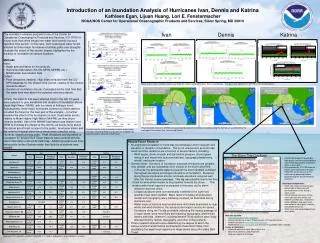
Introduction of an Inundation Analysis of Hurricanes Ivan, Dennis and Katrina Kathleen Egan, Lijuan Huang, Lori E. Fenstermacher NOAA/NOS Center for Operational Oceanographic Products and Services, Silver Spring, MD 20910 Ivan Dennis Katrina • The inundation analysis program is one of the Center for Operational Oceanographic Products and Services (CO-OPS) in-house tools that offers insight into water level activity during a specified time period. In this case, Gulf Coast peak water levels affected by three major hurricanes of similar paths and strengths illustrate the extent of the storms’ impact, highlighted by the duration of inundation at various locations. • Methods • Input: • Begin and end dates for the analysis. • Reference tidal datum (MLLW, MHW, MHHW, etc.). • NOAA water level station data. • Output: • Peak elevations (meters): High tides extracted from the CO- OPS database for the chosen time period, relative to the chosen reference datum. • Duration of inundation (hours): Calculated as the total time that the water level was above the selected reference datum. • Initially, the stations that were affected most in the last 15 years were selected to give elevations and duration of inundation above Mean High Water (MHW), with the intent of finding a trend. Subsequently, three major hurricanes common to these stations provided the focus for the next part of the analysis – to further examine the effect of the hurricanes on Gulf Coast water levels, relative to Mean Higher High Water (MHHW), as they churn towards landfall. Use of the MHHW tidal datum was chosen over MHW to illustrate the impact of the storms, as levels rising above this datum are of most concern to the public. Hurricane tracks and the extent of tropical storm force winds were compiled using Hurrevac (www.hurrevac.com). Peak elevations and durations of inundation for several Gulf Coast stations were overlaid with the storm information onto an ArcGIS map. Additional water level time-series plots further illustrate water level activity at stations near landfall. Katrina 8/29/05 H2 Dennis 7/10/05 H3 Georges 9/28/98 H2 Rita 9/23/05 H4 Arlene 6/11/05 TS Hanna 9/14/02 TS Isidore 9/26/02 TS Danny 7/19/97 H1 Earl 9/3/98 TS Ivan 9/16/04 H3 Dennis 7/10/05 H3 Katrina 8/29/05 H3 Arlene 6/11/05 TS Earl 9/3/98 H1 Isidore 9/26/02 TS Alberto 7/3/94 TS Erin 8/3/95 H1 Water levels relative to Mean Lower Low Water for stations affected by Ivan, Dennis and Katrina. The green line indicates the MHHW reference tidal datum. Rita 9/23/05 H4 Ivan 09/16/04 H3 Dennis 07/10/05 H3 Katrina 08/29/05 H1 Isidore 09/26/02 TS Hanna 09/14/02 TS Opal 10/04/95 H3 Rita 09/23/05 H4 Lili 10/03/02 H1 Josephine 10/07/96 TS Peak elevation relative to MHHW and associated duration of inundation at stations along the Gulf Coast, as affected by the passage of Hurricanes Ivan, Dennis and Katrina. Results from the initial inundation analysis output: peak elevation relative to MHW and duration of inundation for specific stations around the Gulf Coast. • Results/Future Research • No significant correlation or trend was found between storm strength and elevation or duration of inundation. This is not unexpected, as storm tide levels and thus durations are a function of several factors, including: • Wind speed, storm strength and barometric pressure, storm speed, timing of and height with astronomical tides, topography/bathymetry, rainfall, and storm location. • General trend: Durations of inundation and peak elevations are greatest near landfall, and are substantial even outside of the storm wind field. • In Florida, the panhandle stations (nearest the storm landfall) exhibited the highest elevations and longest durations of inundation. Durations along the peninsula were shorter, and peak elevations occurred well after the storms’ nearest passage. This lag was possibly due to the time it took for wind-driven waters to be propelled towards the shore. This weaker water level response is expected in this area, as the storm influence was less direct. • Longest durations were not necessarily confined to the right front quadrant near storm landfall. Major factors including wind direction, rainfall and topography were intricately involved, as illustrated during Hurricane Ivan. • Water levels at stations near landfall were most likely dominated by high winds and wind directions, the actual storm location and storm speed. Elevations along the Florida peninsula, reflecting the nearby passage of a major storm, were most likely dominated by topography, wind-driven waters and tides. Western Louisiana/eastern Texas stations were likely affected most by rainfall, topography, and other indirect effects. • Future research should involve determining the degree to which the various environmental factors contributed to these storm tides, thus elucidating the water level response to large storms along the entire Gulf Coast. Station Ivan Dennis Katrina The Storm Tide Quicklook Time Elevation Duration of inundation Time Elevation Duration of inundation Time Elevation Duration of inundation • NOAA NOS product that provides high quality, real-time oceanographic and meteorological data at locations within a storm path. • Data provided by CO-OPS National Water Level Observation Network (NWLON), which consists of 197 continuously operating stations located along the US/US territories coastline. • Quicklook components: • Storm tide analysis that evaluates and compares observed and predicted water levels during a storm event. • NOAA National Hurricane Center storm advisory information and NESDIS satellite data, relating the station locations and water level information to storm path, intensity and landfall forecasts. • Water level and meteorological time- series plots. Key West, FL 9/14/04 14:24 0.22 6.3 7/9/05 15:12 0.34 16.9 8/26/05 07:00 0.14 5.0 Naples, FL 9/15/04 17:12 0.35 6.1 7/10/05 05:18 0.42 9.4 8/27/05 10:00 0.40 8.2 Port Manatee, FL 9/15/04 19:00 0.60 18.9 St. Petersburg, FL 8/28/05 12:36 0.41 19.5 Clearwater Beach, FL 9/15/04 17:54 0.68 9.6 7/10/05 11:48 0.74 18.0 8/28/05 09:12 0.47 18.3 Cedar Key, FL 9/15/04 19:42 0.76 8.8 7/10/05 17:54 1.22 17.4 8/28/05 13:30 0.50 17.3 Apalachicola, FL 9/16/04 06:54 1.10 55.5 7/10/05 18:48 1.96 65.4 8/28/05 14:12 0.87 68.7 Panama City Beach, FL 9/16/04 06:00 1.55 55.1 7/10/05 19:18 1.65 41.9 8/29/05 12:36 0.90 65.6 Pensacola, FL Damaged 7/10/05 19:54 1.30 41.0 Dauphin Island, AL 9/16/04 04:06 1.81 73.1 7/10/05 19:06 0.72 40.6 8/29/05 17:00 1.58 65.5 Biloxi, Bay of Biloxi, MS 9/16/04 03:30 0.71 30.2 7/10/05 14:18 0.48 14.6 Damaged Storm Tide Quicklook of Hurricane Katrina at landfall. • New site location: • www.tidesandcurrents.noaa.gov • Only posted during a storm threatening the US Coast/territories. • Formerly located at www.tidesonline.noaa.gov. • NOAAWatch (www.noaawatch.gov) links to the Quicklook when available. • Future of Quicklook: • Automate portion of storm tide analysis text. • Map enhancements using Arc2Earth. • Redesign layout of Quicklook. Waveland, MS 9/16/04 06:48 0.96 56.8 7/10/05 14:54 0.47 14.7 Damaged Pilots Station East, LA 9/16/04 02:00 0.75 73.9 Grand Isle, LA 9/15/04 17:06 0.55 80.5 7/11/05 17:36 0.29 38.3 8/29/05 12:42 1.42 41.7 Port Fourchon, LA 9/16/04 06:54 0.59 53.7 Damaged Time is in UTC, elevation (relative to MHHW) is in meters, and duration of inundation is in hours.