
Formation and Types of Weather Fronts
E N D
Presentation Transcript
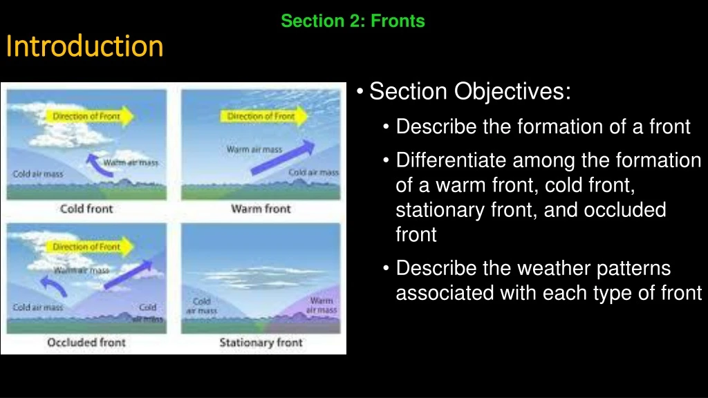
Section 2: Fronts Introduction • Section Objectives: • Describe the formation of a front • Differentiate among the formation of a warm front, cold front, stationary front, and occluded front • Describe the weather patterns associated with each type of front
4. Formation of Fronts • When two air masses with different properties meet, they form a front. • A front is a boundary between two contrasting air masses • Fronts are often associated with some form of precipitation • Most weather fronts are between 15 and 200 km wide • Above Earth’s surface, the surface of the front slopes at a low angle, so that warmer, less dense air overlies cooler, denser air
Formation of Fronts (cont.) • Occasionally, the air masses on both sides of a front move in the same direction and at the same speed • When this happens, the front acts simply as a barrier that travels with the air masses • In most cases, however, the distribution of pressure causes one air mass to move faster than the other • When this happens, one air mass advances into another, and some mixing of air occurs
5. Types of Fronts • Fronts are often classified according to temperature of the advancing front. • There are four types of fronts: • Warm fronts • Cold fronts • Stationary fronts • Occluded fronts
Types of Fronts (cont.) • Warm Fronts • A warm front is a front along which a warm air mass rises over a retreating mass of cold air • A warm front forms when warm air moves into an area formerly covered by cooler air • On a weather map, the surface position of a warm front is shown by a red line with red semicircles. • The semicircles point toward the cooler air mass • The slope of the warm front is very gradual • As warm air rises, it cools to produce clouds and frequent precipitation
Types of Fronts (cont.) • The first sign of the approaching warm front is the appearance of cirrus clouds • As the front comes closer, cirrus clouds change into cirrostratus clouds, which blend into denser sheets of altostratus clouds • About 300 km ahead of the front, thicker stratus and nimbostratus clouds appear, and rain or snow begins • Because of their slow movement and very low slope, warm fronts usually produce light to moderate precipitation over a large area for an extended period of time • A gradual increase in temperature occurs with the passage of a warm front • The increase is most apparent when a large temperature difference exists between adjacent air masses • In the Northern Hemisphere, a wind shift from east to southwest is associated with a warm front
Types of Fronts (cont.) • Cold Front • A cold front forms when cold, dense air moves into a region occupied by warmer air. • As this cold air moves it becomes steeper • On average, cold fronts are about twice as steep as warm fronts and advance more rapidly than warm fronts do • These two differences – rate of movement and steepness slope – account for the more violent weather associated with a cold front • On a weather map, the surface position of a cold front is shown by a blue line edged with blue triangles pointing toward the warmer air mass
Types of Fronts (cont.) • The forceful lifting of air along a cold front can lead to heavy rain and gusty winds • As a cold front approaches, cumulonimbus clouds often can be seen in the distance • Once the cold front has passed, temperatures will drop and wind shifts • The weather behind a cold front is dominated by a cold air mass • Weather clears soon after a cold front passes
Types of Fronts (cont.) • Stationary Front • When the surface position of the front does not move, a stationary front has formed • In a stationary front, two air masses come together but neither displaces the other • Gentle to moderate precipitation can occur • On a weather map, stationary fronts are shown by blue triangles on one side of the front and red semicircles on the other
Types of Fronts (cont.) • Occluded Fronts • When a cold front overtakes a warm front, an occluded front forms • On a weather map, an occluded front is shown by a purple line with triangles and semicircles • Develops as the advancing cold air wedges the worm front upward • Weather is generally complex • Most precipitation is associated with warm air being forced upward • When conditions are suitable, however, the newly formed front is capable of making light precipitation of its own


