Download
1 / 1
10 likes | 211 Vues
The Relationship Between Hemosporidian Parasites and Song Sparrows ( Melospiza melodia ) Along an Urban Gradient. Andrew Bartlow 1 , Katie White 1 , and Jeffrey A. Stratford 1,2 1 Department of Biology, Wilkes University, Wilkes-Barre, PA 2 jeffrey.stratford@wilkes.edu. ABSTRACT

E N D
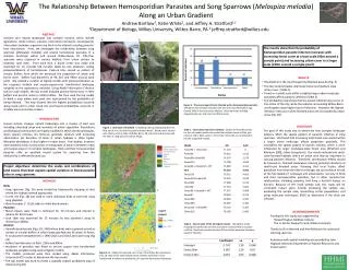
The Relationship Between Hemosporidian Parasites and Song Sparrows (Melospiza melodia) Along an Urban Gradient Andrew Bartlow1, Katie White1, and Jeffrey A. Stratford1,2 1Department of Biology, Wilkes University, Wilkes-Barre, PA 2 jeffrey.stratford@wilkes.edu ABSTRACT Humans turn natural landscapes into complex mosaics, which include agriculture, urban centers, suburbs, and natural remnants. Consequently, interactions between organisms are likely to be altered including parasite-host interactions. Here, we investigate the relationship between song sparrows (Melospiza melodia) and several hematozoan parasites in a complex landscape within and around Wilkes-Barre, PA. Fifty-four sparrows were captured in various habitats from urban centers to relatively rural sites. From each bird, a blood smear was made and examined for 15 minutes (30 minutes total) by two observers noting presence/absence of hematozoans. Capture sites served as centers of circular buffers from which we extracted the proportion of urban and forest cover. Buffers had diameters of 90, 210 and 990m around each point. We created a number of logistic models with presence/absence as the response variable and arcsine-square-root transformed landscape variables as the explanatory variables. Using Akaiki Information Criterion (AIC) to rank models, the top model included percent forest cover in 90m buffers and percent urban in 210m buffers. We then used the top model to build a map where each pixel was represented by the probability of being infected. This map showed that the highest probabilities occurred along roads and in urban wood lots and lowest probabilities occurred in shrubby areas and urban centers. A. B. The results show that the probability of hemosporidian parasite infection increases with increasing forest cover at a local scale (90m around a sample point) and increasing urban cover at a larger scale (210m around a sample point). • RESULTS • Plasmodium is the most frequently detected parasite (Fig. 3) • The top model includes small scale forest and medium scale • urban cover (Table 1) • Forest on a small scale within a slightly larger urban landscape • positively affects parasitic infection (Table 2) • The probability map shows that the lowest infection rates occur in the center of the city, while the suburbs surrounding Wilkes-Barre and Kingston show higher rates of infection. However, the highest infection rates occur when forested areas are surrounded by urban areas (Fig. 2B) D. C. Figure 3. The percentage of birds infected with a hemosporidian parasite. The genus that infected song sparrows the most was Plasmodium spp. Overall, 60% of the birds were infected. Other parasites included Aegyptianella spp. and one microfilaria larvae. INTRODUCTION Human activity changes natural landscapes into a mosaic of land uses including urbanized areas and remnants of native vegetation. Populations and biological communities are highly modified in these altered landscapes. Avian species richness, for instance, generally declines with increasing urbanization yet densities of birds in urban habitats is often higher. Mosquito abundance is also higher in urban areas. Few studies, however, have looked at avian communities or mosquitoes in areas in between urban and natural areas or in complex landscapes. Birds and their hemosporidian parasites offer an excellent model system for exploring how this relationship is affected by land use. DISCUSSION The goal of this study was to determine how complex landscape patterns affect the spatial pattern of parasitic infection in song sparrows. We found that increasing local forest area nested within a larger urban landscape affects parasitism positively. This contradicts the spatial pattern of species richness, which is more influenced by larger landscape-scale forest area (Stratford and Robinson 2005, Urban Ecosystems). Our results indicate that small-scale forested habitats within an urban area may be important in causing parasitic infection. Therefore, conservation efforts should be focused on forested landscapes reducing potential situations of small-scale forested areas. Knowing that local factors affect parasitism more than the entire landscape, we can continue to look at the fine details of landscape and urbanization, not only in birds and their hemosporidian parasites, but in other parasite-host relationships, including parasites that have a harmful impact on humans. Because of the small sample size, this study will be continued. Future plans include increasing the sample size, expanding the sample area, researching vector populations, and using molecular techniques (PCR) to determine if the birds are infected. Figure 1. Overview of methods A. Banding a bird using banding pliers B. Mist net (6 m x 2 m) used to catch individual birds C. Blood smear stained with Giemsa stain D. Map of Wilkes-Barre, PA and surrounding areas with the sites of song sparrow capture (flags). Table 1. Information theoretic methods. Shown are the ΔAIC values for the null model and for the model that includes forest at 90m plus urban at 210m. ΔAIC values > 4 from the null model are considered to be well-supported models. Project objectives: determine the scales and combinations of land covers that best explain spatial variation in blood parasite rates in song sparrows • METHODS • Birds • Song sparrows (Fig. 1A) were located by haphazardly stopping at sites where the habitat seemed appropriate • A mist net (Fig. 1B) was used to catch individual birds at each site using song playback • Blood samples (~ 10 µl) taken to make blood smears • Parasites • Blood smears were fixed in methanol for 10 minutes and stained in Giemsa for 50 minutes • Each slide was examined for 15 minutes by two observers using oil immersion (1000x) • Analysis • Georeferenced points (Figs. 1D, 2AB) where birds were captured served as centers of circular buffers in which landscape features (% urban, % forest, % scrub) were extracted from a 1996 USGS Land Use/Land Cover map (Fig 2A) • Buffers had diameters of 90m, 210m and 990m • Incidence of parasites was fitted to arcsine square root transformed landscape variables using several logistic models • The models produced were then ranked using Akaiki Information Criterion (AIC) in order to determine the top model • The top model was used to create a spatially explicit probability map of infection (Fig 2B) A ACKNOWLEDGMENTS Funding for this study was supported by: Howard Hughes Medical Institute The H. Fenner Research Fund, Wilkes University Thanks to Chris Nemeth and Amy McNumis for assistance catching sparrows. Assistance with spatial modeling was provided by John Hogland, Montana Department of Natural Resources and Conservation Table 2. Source table of the top logistic model. The logistic model showing the coefficients and the p-values for forest at 90m and urban at 210m. Both had p-values less than 0.05 and both positively influence parasitic infection. B Figure 2. A. 1996 Land use/land cover map of the Wilkes-Barre/Scranton area. B. Map of the same spatial extent as A but each pixel is now transformed to reflect the probability of a sparrow having blood parasites.